ي•œêµى–´ë،œ يژکى´ى§€ 보기
Seoul ADEX 2025 Digital Directory
Plan your trip to Seoul ADEX 2025 using our state of the art Digital Directory
Register in seconds with just your email


Directory Features
To help you at the show
In-depth Exhibitor Profiles
Each exhibitor can add as many products and services as they wish, with in-depth information and specifications. This allows buyers to find what they want easily.
Self Provisioning for Exhibitors
Each exhibitor has full control of their content - to edit their company profile, upload products and enter staff details.
Plan your trip
Use the bookmarking and event planning tool to research the companies you would like to visit and the products you are interested in finding. You will be able to locate all of your saved companies on our floorplan
Advanced Search
Utilize our advanced search function to quickly locate products, people, and companies. Our state-of-the-art technology thoroughly scans all exhibitor information, delivering precise and relevant results
Interactive Floorplan
Navigate the show effortlessly with our directory. Use the floorplan to locate companies you want to visit and to find your way to onsite restaurants, toilets and site entrances and exits.
On-platform Messaging
Reach out to exhibitors and visitors directly on our platform to set up meetings, or request more information.
Some of our latest content
Companies, Products, News, Events
 (1)_700.webp)
Augmented Knowledge Corp.
Aviation MRO Simulator (Mixed Reality Version)
Our XR-based aircraft maintenance simulator is officially certified by the Ministry of Land, Infrastructure and Transport (MOLIT) of South Korea for training and education.
It provides specialized training environments for the A321, B737-MAX, and B737-800NG aircraft, featuring over 80 detailed modules—including procedures for engine removal, main landing gear installation, and more.
This subscription-based simulator is fully compatible with smartphones, tablets, and wearable XR devices, enabling seamless access through a cloud-based web service. Users can train anytime, anywhere—perfect for both remote learning and remote maintenance scenarios.
Compared to traditional classroom learning, the XR platform is 4 times more effective and requires only one-third the training time. It also improves user confidence in real-world technical applications by up to 275%.
By transforming traditional paper manuals into immersive, interactive training environments, the simulator delivers the next generation of aircraft MRO education for both civil and defense sectors.

VIRNECT
VIRNECT Make
No Coding Required: Create XR content effortlessly with a drag-and-drop interface.
Industry-Specific Solutions: Suitable for manufacturing, logistics, energy, and various industries.
Multi-Device Compatibility: Works on PCs, tablets, smartphones, and smart glasses (VisionX).
Real-Time Collaboration: Multiple users can edit and share content simultaneously.
_700.webp)
Ray Service, A.S.
Manufacturing of Electromechanical Assemblies
Ray Service, headquartered in Starأ© Mؤ›sto, Czech Republic, is an international innovative manufacturer of cable harnesses, electromechanical assemblies, and electronic equipment. It is also a distributor and integrator of cable components and system products. More than 30 years of experience and intensive development have resulted in a strong, modern enterprise, a reliable and sought-after partner on an international level.
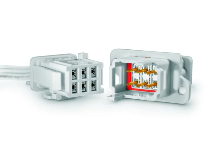
Sangdo Electronics co.,Ltd
REP Series
REP series is easy to use for quick mating. The REP panel and cable connectors are a highly cost-effective interconnect system, which solves the constant need for simple and reliable connector solutions in rail applications. A full plastic solution offered in either wire attachment or PCB mounting options to provide rapid assembly installation without requiring additional mounting hardware. Cable receptacle connectors are available to mate with the cable plug connectors for cable-to- cable solutions when needed. The series is qualified to French and European rail standards. The connectors are available as one overmolded plastic part to save assembly time.
View page in English
Seoul ADEX 2025 Digital Directory
ë””ى§€ي„¸ ë””ë ‰ي„°ë¦¬ë¥¼ ى‚¬ىڑ©ي•کى—¬ ى„œىڑ¸ ADEX 방문 계يڑچى„ ىˆک립ي•کى„¸ىڑ”
ى´ë©”ى¼ë،œ ê°„يژ¸ 등ë،ي• ىˆک ىˆىٹµë‹ˆë‹¤


ë””ë ‰ي„°ë¦¬ 기ëٹ¥
ى „ى‹œيڑŒ ëڈ„ىڑ°ë¯¸
In-depth Exhibitor Profiles
Each exhibitor can add as many products and services as they wish, with in-depth information and specifications. This allows buyers to find what they want easily.
Self Provisioning for Exhibitors
Each exhibitor has full control of their content - to edit their company profile, upload products and enter staff details.
방문 계يڑچ ىˆک립
ë¶پ마يپ¬ ëڈ„구ى™€ ى´ë²¤يٹ¸ ي”Œëک너를 ى‚¬ىڑ©ي•´ 방문ي•کê³ ىگ ي•کëٹ” 기ى—…ê³¼ ê´€ى‹¬ ىˆëٹ” ى œي’ˆى„ ê²€ىƒ‰ي•کى„¸ىڑ”. ى €ى¥ي•œ ëھ¨ë“ ي•ëھ©ى„ ى،°يڑŒي• ىˆک ىˆىٹµë‹ˆë‹¤
ê³ ê¸‰ ê²€ىƒ‰
ê³ ê¸‰ ê²€ىƒ‰ 기ëٹ¥ى„ ى‚¬ىڑ©ي•کى—¬ ىƒپي’ˆ, ى¸ë¬¼, 기ى—…ىک ىœ„ى¹ک를 ë¹ ë¥´ê²Œ ى،°يڑŒي• ىˆک ىˆىٹµë‹ˆë‹¤. ىµœى²¨ë‹¨ 기ىˆ ى„ ي†µي•´ ëھ¨ë“ ى°¸ê°€ى‚¬ىک ى •ë³´ë¥¼ ى² ى €يˆ ىٹ¤ى؛”ي•کى—¬ ى„¸ë°€ي•کê³ ê´€ë ¨ى„± ىˆëٹ” ى •ë³´ë¥¼ ى œê³µي•©ë‹ˆë‹¤
ىƒپيک¸ى‘ىڑ© ê°€ëٹ¥ يڈ‰ë©´ëڈ„
ë””ë ‰ي„°ë¦¬ë¥¼ ى‚¬ىڑ©ي•´ ى „ى‹œيڑŒë¥¼ ى†گى‰½ê²Œ ë‘کëں¬ë³´ى„¸ىڑ”. 방문ي•کê³ ىگ ي•کëٹ” 기ى—…ىک ىœ„ى¹کى™€, ي–‰ى‚¬ى¥ ë‚´ ى‹ë‹¹, ي™”ى¥ى‹¤, ى¶œى…구를 يڈ‰ë©´ëڈ„ى—گى„œ ى°¾ى„ ىˆک ىˆىٹµë‹ˆë‹¤.
ي”Œë«يڈ¼ ë‚´ ë©”ى‹œى§€
ي”Œë«يڈ¼ ىƒپىک ى „ى‹œ ى°¸ê°€ى‚¬ى™€ ê´€ëŒê°ى—گ게 ى§پى ‘ ى—°ë½ي•کى—¬ 미يŒ…ى„ ى‹ ى²ي•کê±°ë‚ک ى¶”ê°€ ى •ë³´ë¥¼ ىڑ”ى²ي•کى„¸ىڑ”.
ىµœى‹ ى½کي…گى¸
기ى—…, ىƒپي’ˆ, 뉴ىٹ¤, ى´ë²¤يٹ¸
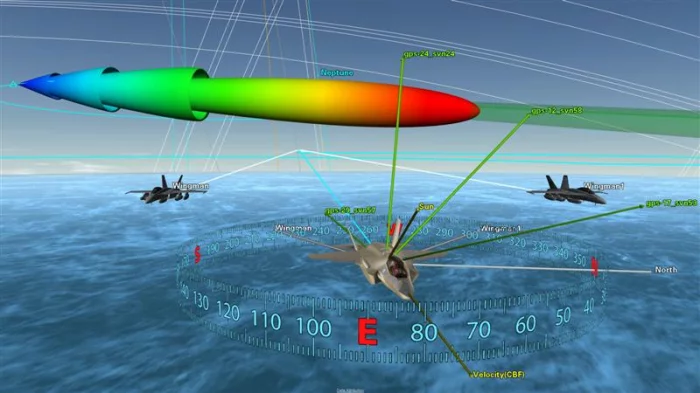
Ansys_Korea
Digital Mission Engineering
Digital mission engineering tools connect every stage of the engineering product lifecycle, from initial design to operation. They enable reality-based 3D simulation across multi-domain environments such as air, space, land, and sea by incorporating high-resolution terrain, satellite orbits, RF and radar systems, and sensor environments to accurately replicate real mission conditions.
With accurate dynamics-based physical models at the core, these tools provide quantitative analysis of relative positioning between systems, changes in altitude and attitude, line-of-sight availability, and communication link status. Users can predict and evaluate mission elements such as sensor operations, communication links, platform maneuvers, and orbit optimization through scenario-based simulations.
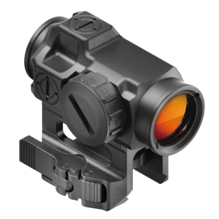
SU Optics
ACTUSآ® CORE-2 Dot Sight
The ACTUSآ® CORE-2 Dot Sight is a high-performance optical device chosen as the Warrior Platform Selection Equipment by the Republic of Korea Army (ROKA).
Built to MIL-SPEC standards, it is a further development of our ACTUSآ® CORE-1 Dot Sight. Housed in a smaller form factor, the ACTUSآ® CORE-2 meets rigorous military requirements, including extreme temperature resistance, shock testing, waterproofing, and protection against fluid contamination. Designed for durability and reliability, the CORE-2 enhances operator safety in the field, ensuring quick and precise target acquisition during critical missions.
 (5)_700.webp)
KOREA NON-FERROUS METALS CO., LTD.
Aluminium Alloy Sheet
KNF offers high qualified Aluminium products used in a wide range of markets around the world.
*No.1 Stockholding & Qualified Aluminium Supplier
*A1XXX/A2XXX/A3XXX/A5XXX/A6XXX/A7XXX Series and more
*Business Areas: Aerospace & Defense / Semiconductor & Display / Marine & Silo / Automotive & EV Battery / Others
_700.webp)
Shakad
X1-Mobile Explosives Detector
This explosive detector, built on a photochemical sensor, is a security device that detects traces of explosives by sucking in the surrounding air. It is scheduled for trial application at APEC 2025.
ى§€ê¸ˆ ë°”ë،œ 등ë،ي•کى—¬ ë””ë ‰ي„°ë¦¬ë¥¼ ى—´ëŒي•کى„¸ىڑ”
ى§€ê¸ˆ ë°”ë،œ 등ë،ي•کى—¬ ë””ë ‰ي† 리를 ى—´ëŒي•کى„¸ىڑ”
Right Now.
