한국어로 페이지 보기
Seoul ADEX 2025 Digital Directory
Plan your trip to Seoul ADEX 2025 using our state of the art Digital Directory
Register in seconds with just your email


Directory Features
To help you at the show
In-depth Exhibitor Profiles
Each exhibitor can add as many products and services as they wish, with in-depth information and specifications. This allows buyers to find what they want easily.
Self Provisioning for Exhibitors
Each exhibitor has full control of their content - to edit their company profile, upload products and enter staff details.
Plan your trip
Use the bookmarking and event planning tool to research the companies you would like to visit and the products you are interested in finding. You will be able to locate all of your saved companies on our floorplan
Advanced Search
Utilize our advanced search function to quickly locate products, people, and companies. Our state-of-the-art technology thoroughly scans all exhibitor information, delivering precise and relevant results
Interactive Floorplan
Navigate the show effortlessly with our directory. Use the floorplan to locate companies you want to visit and to find your way to onsite restaurants, toilets and site entrances and exits.
On-platform Messaging
Reach out to exhibitors and visitors directly on our platform to set up meetings, or request more information.
Some of our latest content
Companies, Products, News, Events
AIR COST CONTROL
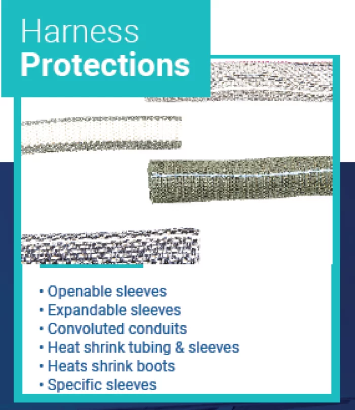
Harness Protections
• Openable sleeves
• Expandable sleeves
• Convoluted conduits
• Heat shrink tubing & sleeves
• Heats shrink boots
• Specific sleeves
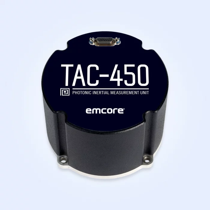
EMCORE
TAC-450-360 Photonic Inertial Measurement Unit (IMU) (Non-ITAR)
Designed to deliver the highest level of performance, the non-ITAR TAC-450-360 IMU includes our exclusive photonic integrated chip (PIC) technology. The high-performance TAC-450-360 IMU is designed for applications in which high bandwidth, low latency, and low drift are critical. The TAC-450-360 IMU is integrated with inertial-grade accelerometers and three axes of magnetometers to provide the high accuracy levels that leading autonomous and manned platforms demand.
Highlights
Designed for ease of integration with flexible interface settings and programmable message outputs
Excellent performance in critical applications and the specs that matter most
Improved SWaP plus robust performance and survivability
Technology Details
Photonic Integrated Chip Technology
EMCORE’s photonic integrated chip (PIC) technology* reimagines FOG technology by replacing individual fiber components with an innovative integrated planar optic chip. This results in a FOG with PIC Inside™ that’s reliable and robust. With three of these integrated photonic gyros at its core, the TAC-450-360 IMU provides the safe, accurate performance autonomous platforms demand.
ZYX Technology
DIVE
DIVE (Digital Interactive Virtual Environment) is a GIS-based smart construction management platform jointly developed by ZYX Technology and Korea Expressway Corporation. Designed to meet the growing demand for intelligent infrastructure solutions, DIVE provides real-time integration, monitoring, and analysis of all location-based construction data.
By consolidating diverse sources such as design drawings, land maps, aerial imagery, BIM data, drone footage, and CCTV into a single platform, DIVE enables comprehensive, on-site visibility and control. From large-scale infrastructure to complex tunnel projects, all key information can be accessed and compared in real time, allowing for smarter, faster, and more accurate decision-making.
The main dashboard provides a live overview of each project site, including tasks, equipment, workers, events, and safety issues. With its daily work management feature, site managers can view exact personnel and equipment allocations for each zone, improving efficiency and minimizing risk.
DIVE also supports seamless integration with tunnel monitoring systems, offering real-time access to excavation status, geotechnical sensors, and worker presence inside the tunnel. This ensures enhanced safety and process transparency in high-risk environments.
Drone integration further strengthens site management by providing up-to-date aerial visuals, reducing blind spots and enabling rapid response to field changes. In addition, the platform links design drawings with cadastral maps to streamline permitting, track construction progress, and manage change orders with geographic accuracy.
Whether you're building roads, tunnels, or complex infrastructure, DIVE empowers construction teams with a powerful digital environment to manage the entire project lifecycle.
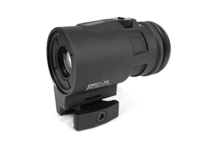
EO System
Prism Optic Weapon Sight
EM21 is designed to be used behind the EOST EDS Red Dot Reflex Sight. EM21 can be mounted right behind the EOST EDS (or any of other dot and holographic sight) to give 3 times magnifying view.
EM21 helps shooter convert the optical magnification so that he can have better target acquisition and fast target engagement capability. The ability to transition between the two distances almost instantly and still maintain weapon accuracy is easily achieved with our EM21. Simply switch the magnifier out of the way for a quick 1X targeting.
EM21 can be used for hunting/recreational purpose.

View page in English


디렉터리 기능
전시회 도우미
In-depth Exhibitor Profiles
Each exhibitor can add as many products and services as they wish, with in-depth information and specifications. This allows buyers to find what they want easily.
Self Provisioning for Exhibitors
Each exhibitor has full control of their content - to edit their company profile, upload products and enter staff details.
방문 계획 수립
북마크 도구와 이벤트 플래너를 사용해 방문하고자 하는 기업과 관심 있는 제품을 검색하세요. 저장한 모든 항목을 조회할 수 있습니다
고급 검색
고급 검색 기능을 사용하여 상품, 인물, 기업의 위치를 빠르게 조회할 수 있습니다. 최첨단 기술을 통해 모든 참가사의 정보를 철저히 스캔하여 세밀하고 관련성 있는 정보를 제공합니다
상호작용 가능 평면도
디렉터리를 사용해 전시회를 손쉽게 둘러보세요. 방문하고자 하는 기업의 위치와, 행사장 내 식당, 화장실, 출입구를 평면도에서 찾을 수 있습니다.
플랫폼 내 메시지
플랫폼 상의 전시 참가사와 관람객에게 직접 연락하여 미팅을 신청하거나 추가 정보를 요청하세요.
최신 콘텐츠
기업, 상품, 뉴스, 이벤트
Honeywell Aerospace Technologies
IntuVue RDR-7000 Weather Radar System
The IntuVue RDR-7000 is fully automatic and does'nt require active pilot adjustments of tilt and/or gain for operation. Reducing workload, allows pilots to focus on flying the most comfortable and safest route through weather.
Engineered to provide far superior reliability, accuracy and durability than legacy magnetron-based radar systems, the RDR-7000 offers customers the flexibility to remotely enable advanced software features to provide them the clearest view of weather conditions around the routes they’re accustomed to flying.
Key Honeywell Advantages:
Next generation -fully automated, higher resolution weather radar system with airborne ground/sea mapping system
Reliable and efficient - solid-state transmitters utilizing pulse compression provide reduced weight and power consumption, advanced coherent processing, and increased reliability
Compact and easy to install - RDR-7000 IntuVue radar systems technology integrated into a small, lightweight package
Available software upgrades - advanced features can be added at any time, including turbulence detection, advanced mapping, target detection and additional hazard features (lightning and hail detection), and forward looking (predictive) windshear
Honeywell's RDR 7000 Radar helps in operational costs savings by reducing the delays & downtime caused due to hailstorm, weather incidents and windshears while optimizing routes to reduce diversions and turnbacks.
GE Aerospace
Military Systems
GE Aviation's Systems business is equipping militaries with the solutions needed to succeed. As a leading supplier of integrated systems and technologies for combat aircraft, military transport, helicopters, land vehicles and unmanned aerial vehicles (UAVs), GE is enabling armed forces around the world to improve reliability and enhance operational performance.
SAFRAN
Aircraft Modification and Certification
Safran Engineering Services was selected by Honeywell for the STC development for multiple rotorcrafts. Safran Engineering Services took responsibility as the design authority for the design, development, integration, installation, testing, tech pubs and STC approval under FAA, EASA and TC agencies.
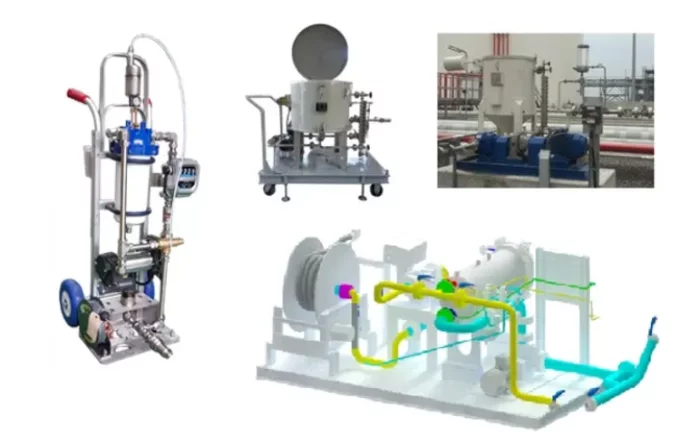
LEES Corporation
Aviation fuel refueling skid
aviation fuel refueling cart
: Mobile refueling cart that can easily refuel light aircraft and helicopters
Sump recovery system
: Collect the drained/sumped aviation fuel from the aviation fuel refueling system, easily sample and test it, and then decide whether to drain it or return it to the system.
Aviation fuel refueling system
: The aviation fuel refueling system is compactly constructed with a skid for easy use and installation.