한국어로 페이지 보기
Seoul ADEX 2025 Digital Directory
Plan your trip to Seoul ADEX 2025 using our state of the art Digital Directory
Register in seconds with just your email


Directory Features
To help you at the show
In-depth Exhibitor Profiles
Each exhibitor can add as many products and services as they wish, with in-depth information and specifications. This allows buyers to find what they want easily.
Self Provisioning for Exhibitors
Each exhibitor has full control of their content - to edit their company profile, upload products and enter staff details.
Plan your trip
Use the bookmarking and event planning tool to research the companies you would like to visit and the products you are interested in finding. You will be able to locate all of your saved companies on our floorplan
Advanced Search
Utilize our advanced search function to quickly locate products, people, and companies. Our state-of-the-art technology thoroughly scans all exhibitor information, delivering precise and relevant results
Interactive Floorplan
Navigate the show effortlessly with our directory. Use the floorplan to locate companies you want to visit and to find your way to onsite restaurants, toilets and site entrances and exits.
On-platform Messaging
Reach out to exhibitors and visitors directly on our platform to set up meetings, or request more information.
Some of our latest content
Companies, Products, News, Events
CanLab
EO/IR Camera (GIMBAL Type)
A compact EO/IR gimbal camera system designed for UAVs, unmanned surface vehicles, and defense platforms. The system integrates a QVGA/VGA-class LWIR thermal imager and a high-resolution EO camera within a stabilized gimbal, ensuring reliable performance in diverse environmental conditions. Optimized for ISR (Intelligence, Surveillance, Reconnaissance) missions, the system provides detection, recognition, and identification (DRI) capabilities with low-SWaP (Size, Weight, and Power) characteristics.
Teledyne FLIR LLC
Airborne Systems
With more than 3,000 EO/IR sensors on order or delivered, the Star SAFIRE® series provides the longest range performance in its class.
Haigh-Farr, Inc.
Haigh Farr at the Virtual NH Career Fair, hosted by JobsInNH
Presentation by Haigh Farr during the Virtual NH Career Fair, hosted by JobsInNH.
PABLO AIR
PabloM R10s
The R10s is a reconnaissance and surveillance drone capable of conducting up to two hours of mission flight, transmitting real-time information such as target location and scale to the ground control system. Based on the company’s innovative vertical take-off and landing (VTOL) platform “Bluebird,” the R10s is equipped with EO/IR optical sensors and a laser range finder for advanced target detection. Upon receiving mission orders, the R10s takes off vertically, transitions to fixed-wing flight, and proceeds to the designated area. Its onboard cameras and sensors identify and track targets, relaying precise coordinates to the ground control system. With modular wing replacement, the R10s can be configured for extended endurance of around two hours or for high-speed maneuverability, ensuring optimal adaptability and mission effectiveness across diverse operational scenarios.
View page in English


디렉터리 기능
전시회 도우미
In-depth Exhibitor Profiles
Each exhibitor can add as many products and services as they wish, with in-depth information and specifications. This allows buyers to find what they want easily.
Self Provisioning for Exhibitors
Each exhibitor has full control of their content - to edit their company profile, upload products and enter staff details.
방문 계획 수립
북마크 도구와 이벤트 플래너를 사용해 방문하고자 하는 기업과 관심 있는 제품을 검색하세요. 저장한 모든 항목을 조회할 수 있습니다
고급 검색
고급 검색 기능을 사용하여 상품, 인물, 기업의 위치를 빠르게 조회할 수 있습니다. 최첨단 기술을 통해 모든 참가사의 정보를 철저히 스캔하여 세밀하고 관련성 있는 정보를 제공합니다
상호작용 가능 평면도
디렉터리를 사용해 전시회를 손쉽게 둘러보세요. 방문하고자 하는 기업의 위치와, 행사장 내 식당, 화장실, 출입구를 평면도에서 찾을 수 있습니다.
플랫폼 내 메시지
플랫폼 상의 전시 참가사와 관람객에게 직접 연락하여 미팅을 신청하거나 추가 정보를 요청하세요.
최신 콘텐츠
기업, 상품, 뉴스, 이벤트
Hessed Korea
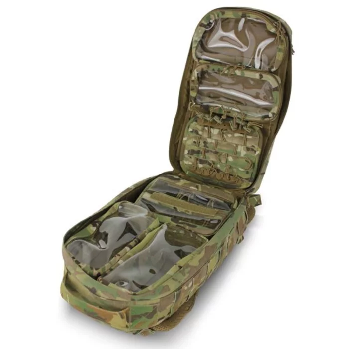
RIGGER STYLE GUNFIGHTER BELT - GFB114
Dim. : 2"W
High strength type 13 webbing
2 rows of 1/2" MOLLE webbing
Removable antimicrobial/FR treated spacer mesh pad
2" Cobra® buckle
Vertical pull test 6,800 lbs +/-5%
Loop/hook selectable at the inner Velcro
Composition
Material : 500D Cordura® + ARAMID / PV®
Size :
SMALL 32" - 35.5"
MEDIUM 34.5" - 38"
LARGE 38" - 41.5"
Color :
MC (MultiCam)
BMC (Black MultiCam)
BK (Black)
RG (Ranger Green)
CYT (Coyote Brown)
TelePIX Co., Ltd.
BlueBON
The world’s first satellite dedicated to blue carbon monitoring, launched in January 2025. Equipped with an AI-powered onboard processor, BlueBON processes electro-optical data directly in orbit, reducing latency and eliminating the need for energy-intensive ground-based processing. This establishes a new model for sustainable, application-driven EO missions.
AeroMaster Corporation (AMC)
DTRS
Consists of a Data Transmission and Recording Unit (DTRU) for data transmission and collection, and a Removable Mass Memory (RMM) for data storage.
Stores pre-planned flight mission data in the RMM on the ground and transmits it to the aircraft via the DTRU.
Collects various mission data (flight data, monitoring data, video data, and audio data) during flight, stores it in the RMM, and transmits it to the ground for mission analysis.
- x5 ARINC-818 Recording as H.264
- x2 Analog audio recording
- x7 MIL-STD-1553B Bus Monitoring
- x2 Gigabit Ethernet Monitoring
- 512GB Solid-State Disk (up to 2TB)
- Size : 160.1x146.0x232.4 mm
- Weight : 4.25Kg
- Power : MIL-STD-704F (28VDC, 58W)
- Environment: MIL-STD-810G
- EMI/EMC: MIL-STD-461G
Saab
r-TWR air traffic management system
r-TWR are digital towers which enable the remote use of air traffic services (ATS) from any location. Being at an airport, air base or at a centralised location, distance is no longer a factor. The r-TWR functions can be integrated to a traditional tower as a hybrid solution, and can support the ramp and apron management using the same information. It can also be deployed and put in place when needed.
Through the use of digital camera technology and sensors, operators can effectively conduct and manage various services remotely, based
on visual surveillance. This removes the need to be on-site and occupying critical space at an airport, in favour of a chosen location.
Digital Directory