한국어로 페이지 보기
Seoul ADEX 2025 Digital Directory
Plan your trip to Seoul ADEX 2025 using our state of the art Digital Directory
Register in seconds with just your email


Directory Features
To help you at the show
In-depth Exhibitor Profiles
Each exhibitor can add as many products and services as they wish, with in-depth information and specifications. This allows buyers to find what they want easily.
Self Provisioning for Exhibitors
Each exhibitor has full control of their content - to edit their company profile, upload products and enter staff details.
Plan your trip
Use the bookmarking and event planning tool to research the companies you would like to visit and the products you are interested in finding. You will be able to locate all of your saved companies on our floorplan
Advanced Search
Utilize our advanced search function to quickly locate products, people, and companies. Our state-of-the-art technology thoroughly scans all exhibitor information, delivering precise and relevant results
Interactive Floorplan
Navigate the show effortlessly with our directory. Use the floorplan to locate companies you want to visit and to find your way to onsite restaurants, toilets and site entrances and exits.
On-platform Messaging
Reach out to exhibitors and visitors directly on our platform to set up meetings, or request more information.
Some of our latest content
Companies, Products, News, Events
Kallman Worldwide, Inc.
Kallman Creative Services
Build Confidence from the ground up! Your partner for custom built exhibits - any trade show, anywhere in the world. From the initial brief to the last detail, our approach is simple: we’re hands-on partners and honest collaborators who listen, design, and build to your specifications — on strategy, on time, on budget.
Turn heads with a custom-built exhibit from Kallman Creative Services. Take pride in owning an event destination that stops visitors in their tracks and jump-starts sales conversations.
Custom Builds - Chalets - Pavilions - Corporate Events
AeroMaster Corporation (AMC)
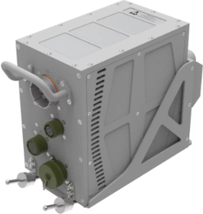
DTMU
Generates 2D electronic map images using a terrain database and transmits them to the mission computer via the ARINC-818 standard.
Using Collins Aerospace's TERPROM software, enabling automatic terrain-following flight and terrain collision avoidance functions.
- x2 Gigabit Ethernet
- x1 MIL-STD-15583B
- x4 Discrete Input
- x2 Discrete Output
- x4 ARINC-818 Transmit
- 512GB Solid-State Disk (Digital Moving Map)
- 64GB Solid-State Disk (TERPROM)
- Size : 135.1x339.0x225.4 mm
- Weight : 4.25Kg
- Power : MIL-STD-704F (28VDC, 60W)
- Environment: MIL-STD-810G
- EMI/EMC: MIL-STD-461G
Dymstec. Co., Ltd.
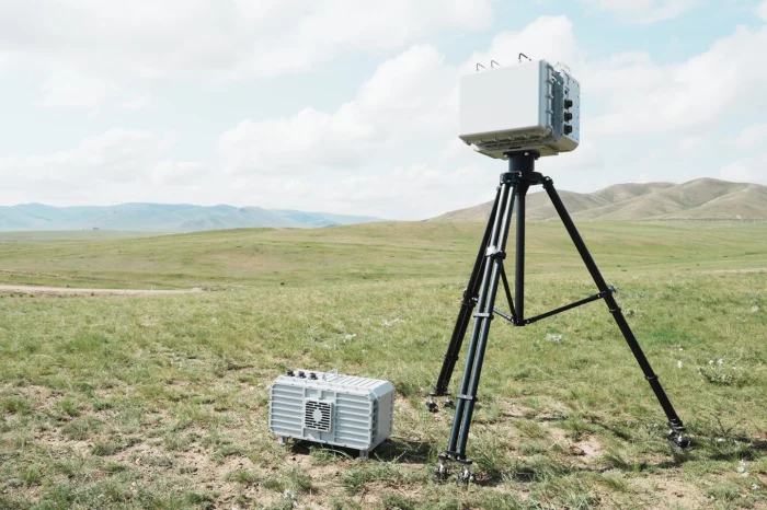
DRONE HUNTER FD
Drone Hunter FD is a powerful countermeasure against drone threats. Designed to cover ISM bands and GNSS L1 , L2, L5 it effectively neutralizes a single drone or multiple drones approaching in a direction from a distance of 5km and operating within its antenna beam width. It is equipped with high-power amplifiers and signal generators to enable powerful multi-band continuous jamming.
This field-proven solution operates with a positioner that receives data from a seamlessly integrated detection/identification system by OURANOSTM C2 or third-party systems. In addition, it can be used as a stationary/mobile solution.

Shakad
X2-Landmine and Explosive Detector
Our advanced mine detector combines photochemical and metal detection technologies, enabling the identification of both metallic and non-metallic mines. Selected in December 2024 for the Global Small but Strong Enterprise Development Program by KRIT, this cutting-edge system is now under development. Backed by a Letter of Commitment from Ukraine, it is set to play a key role in reconstruction and humanitarian demining efforts.

View page in English


디렉터리 기능
전시회 도우미
In-depth Exhibitor Profiles
Each exhibitor can add as many products and services as they wish, with in-depth information and specifications. This allows buyers to find what they want easily.
Self Provisioning for Exhibitors
Each exhibitor has full control of their content - to edit their company profile, upload products and enter staff details.
방문 계획 수립
북마크 도구와 이벤트 플래너를 사용해 방문하고자 하는 기업과 관심 있는 제품을 검색하세요. 저장한 모든 항목을 조회할 수 있습니다
고급 검색
고급 검색 기능을 사용하여 상품, 인물, 기업의 위치를 빠르게 조회할 수 있습니다. 최첨단 기술을 통해 모든 참가사의 정보를 철저히 스캔하여 세밀하고 관련성 있는 정보를 제공합니다
상호작용 가능 평면도
디렉터리를 사용해 전시회를 손쉽게 둘러보세요. 방문하고자 하는 기업의 위치와, 행사장 내 식당, 화장실, 출입구를 평면도에서 찾을 수 있습니다.
플랫폼 내 메시지
플랫폼 상의 전시 참가사와 관람객에게 직접 연락하여 미팅을 신청하거나 추가 정보를 요청하세요.
최신 콘텐츠
기업, 상품, 뉴스, 이벤트

BAE Systems
Intelligent Autonomous Systems R&D
Success in modern warfare requires technologies that use adaptive intelligence processing to help military personnel make better decisions faster and stay ahead of opponents at every stage of mission. That's what our Autonomy R&D teams excel at creating, and it's what our unparalleled autonomous solutions deliver on land, at sea, in the air, in space, and beyond.
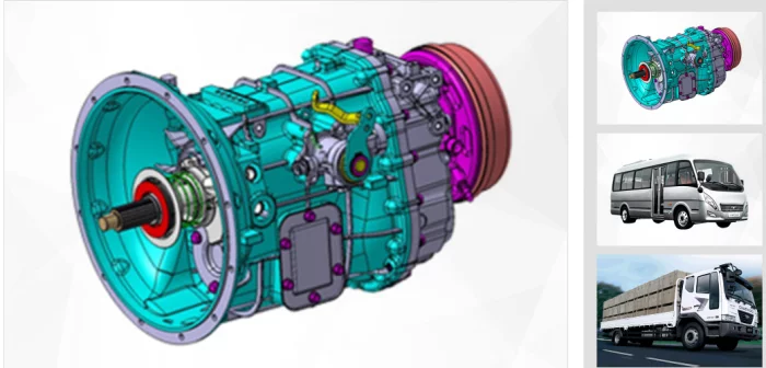
SNT Dynamics
Automotive Parts
characteristicRear wheel drive type (5 forward speeds, 1 reverse speed)
Cable Remote Control Type
2nd and 3rd speed Triple Synchro applied
apply2.5-ton trucks and medium-sized buses,
3.5-ton trucks and medium-sized buses
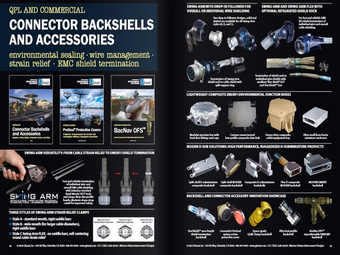
Glenair
Backshells and Accessories
The World's Most Complete Selection with Lightning Fast (Same-day!) Availability for: AS85049 (M85049), D38999, MIL-DTL-26500, MIL-DTL-28840, MIL-DTL-83513, MIL-DTL-83538, MIL-DTL-83723, MIL-S-81824, MS17349, MS27291 and Other Military Standard and Commercial Backshell Derivatives.
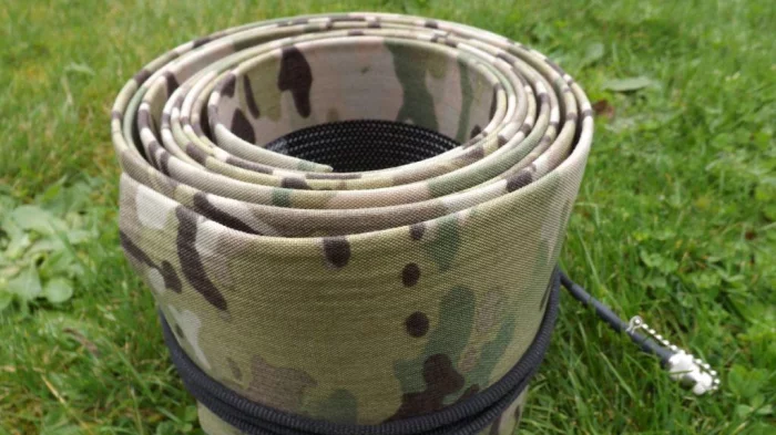
HYTEC INTER KOREA Co., Ltd
Rolatube System IAM
Rolatube IAM (Integrated Antenna Mast) is a lightweight, man-portable communications mast that integrates a high-efficiency dipole antenna directly into its structure—redefining rapid tactical deployment. Built from Rolatube’s proprietary bistable composite, the IAM unrolls to full height without tools, enabling users to connect and transmit in seconds. Available in 3.5 m and 7 m models, the mast weighs just 1.9 kg and packs down to a 150 mm roll, offering unmatched portability for dismounted operations.
Designed for reliable RF performance, the IAM ensures no signal loss when in contact with grounded surfaces. Its embedded omni-directional dipole antenna delivers superior range and VOR communication performance compared to traditional systems. The 3.5 m IAM comes in VHF (30–300 MHz) and UHF (136–470 MHz) variants, each available in four colours, with a top-cap socket for L-Band antenna integration, extending the system’s use to applications such as telemetry, GPS, and aircraft surveillance.
The mast can be handheld, guyed, or elevated via an integrated rigging point, and is engineered to meet MIL-STD-810G, fully maintenance-free, and resistant to water, dust, and UV. With a wind rating of 100 km/h (62 mph) when guyed, the IAM stands up to demanding field environments while delivering high-performance, elevated communications infrastructure at the tactical edge.