한국어로 페이지 보기
Seoul ADEX 2025 Digital Directory
Plan your trip to Seoul ADEX 2025 using our state of the art Digital Directory
Register in seconds with just your email


Directory Features
To help you at the show
In-depth Exhibitor Profiles
Each exhibitor can add as many products and services as they wish, with in-depth information and specifications. This allows buyers to find what they want easily.
Self Provisioning for Exhibitors
Each exhibitor has full control of their content - to edit their company profile, upload products and enter staff details.
Plan your trip
Use the bookmarking and event planning tool to research the companies you would like to visit and the products you are interested in finding. You will be able to locate all of your saved companies on our floorplan
Advanced Search
Utilize our advanced search function to quickly locate products, people, and companies. Our state-of-the-art technology thoroughly scans all exhibitor information, delivering precise and relevant results
Interactive Floorplan
Navigate the show effortlessly with our directory. Use the floorplan to locate companies you want to visit and to find your way to onsite restaurants, toilets and site entrances and exits.
On-platform Messaging
Reach out to exhibitors and visitors directly on our platform to set up meetings, or request more information.
Some of our latest content
Companies, Products, News, Events

SNT Dynamics
Diamler Housing Ass'y
Product Specifications: Reduce weight and achieve high durability by applying high-strength materials
Customer Mercedes-Benz in Germany
Teledyne FLIR LLC
UAS & UGS for Government and Defense
Arm the Future Force with Battle-Tested Unmanned Systems FLIR offers several Unmanned Aerial Systems, ranging in size from the world's smallest nano-UAS to its Group 1 VTOL platform, which has more operational heritage than any other asset in its class.
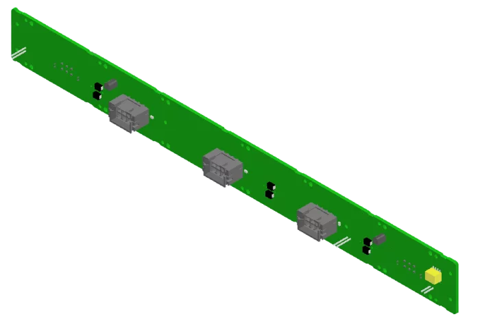
SeedCore
SCFAN-CTRL-10U
The SCFAN-CTRL-10U is an internal fan control module installed inside the chassis to provide advanced cooling control and system thermal management.
It integrates with FAN trays and operates through Kontron’s Power Supply Control Module (PSCM), supporting up to two 12V @ 3.5A fans and seven 12V @ 2.5A fans.
This module ensures stable cooling performance and system reliability for high-density VPX-based embedded systems.
It is deployed in the M-SAM-II multi-function radar system, where it provides precise and efficient cooling control for mission-critical radar operations.
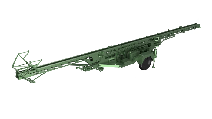
FINE KOWAC Co., Ltd.
UAV Catapult Launcher
This is the UAV launchers capable of launching the fixed-wing UAVs even on mountainous terrain, field, ships without sufficient runways to take off. It is designed to be the most powerful and easy to operate to take off the fixed-wing type UAVs of various specifications(Take-off weight, Take-off speed, and allowable G-force) into the air.
It provides an interface that standardizes the shuttle for any type of unmanned aviation vehicle, and is easy to mount and to avoid take-off interference.
A specially designed and manufactured hydraulic actuator is used to fully cope with the take-off weight of the aircraft, and a proprietary accumulator to allow a wide range of launch speed control. And multiple pulleys are equipped to ensure acceleration performance.

View page in English


디렉터리 기능
전시회 도우미
In-depth Exhibitor Profiles
Each exhibitor can add as many products and services as they wish, with in-depth information and specifications. This allows buyers to find what they want easily.
Self Provisioning for Exhibitors
Each exhibitor has full control of their content - to edit their company profile, upload products and enter staff details.
방문 계획 수립
북마크 도구와 이벤트 플래너를 사용해 방문하고자 하는 기업과 관심 있는 제품을 검색하세요. 저장한 모든 항목을 조회할 수 있습니다
고급 검색
고급 검색 기능을 사용하여 상품, 인물, 기업의 위치를 빠르게 조회할 수 있습니다. 최첨단 기술을 통해 모든 참가사의 정보를 철저히 스캔하여 세밀하고 관련성 있는 정보를 제공합니다
상호작용 가능 평면도
디렉터리를 사용해 전시회를 손쉽게 둘러보세요. 방문하고자 하는 기업의 위치와, 행사장 내 식당, 화장실, 출입구를 평면도에서 찾을 수 있습니다.
플랫폼 내 메시지
플랫폼 상의 전시 참가사와 관람객에게 직접 연락하여 미팅을 신청하거나 추가 정보를 요청하세요.
최신 콘텐츠
기업, 상품, 뉴스, 이벤트
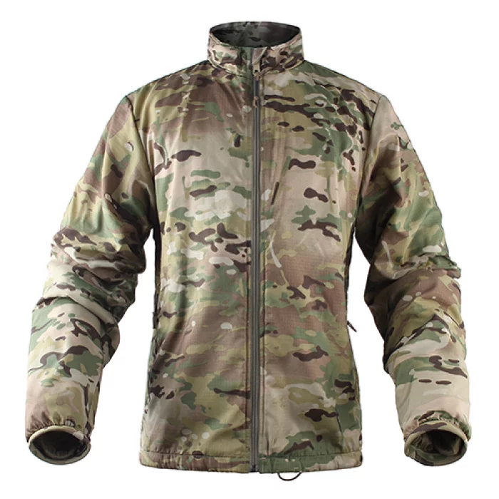
Hessed Korea
HURON ALPHA JACKET
Durable, ultra-light-weight, body temperature protection
Extremely light-weight & packable
YKK Zipper
Wrist cuffs to prevent heat
Elastic string applied to the hem
Composition
Outside : DWR Water Repellent 70D Ripstop Nylon
Filling : POLARTEC's ALPHA meterial
Size : SM, MD, LG, XL, 2XL
Colors
MC (MultiCam)
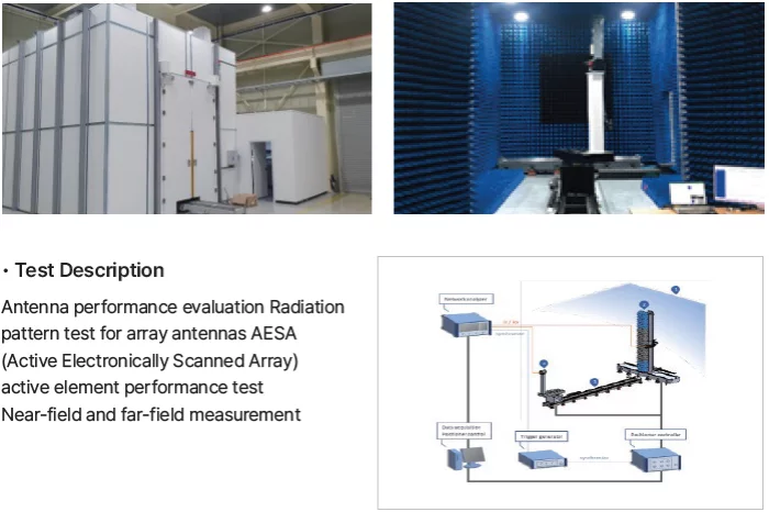
RF Systems
Antenna Measurement Technology
RF Systems' advanced facilities support accurate performance testing and RF measurement of antenna. With specialized tools and expertise, we ensure consistent quality and verified performance in all key parameters.

VIRNECT
VIRNECT Make
No Coding Required: Create XR content effortlessly with a drag-and-drop interface.
Industry-Specific Solutions: Suitable for manufacturing, logistics, energy, and various industries.
Multi-Device Compatibility: Works on PCs, tablets, smartphones, and smart glasses (VisionX).
Real-Time Collaboration: Multiple users can edit and share content simultaneously.
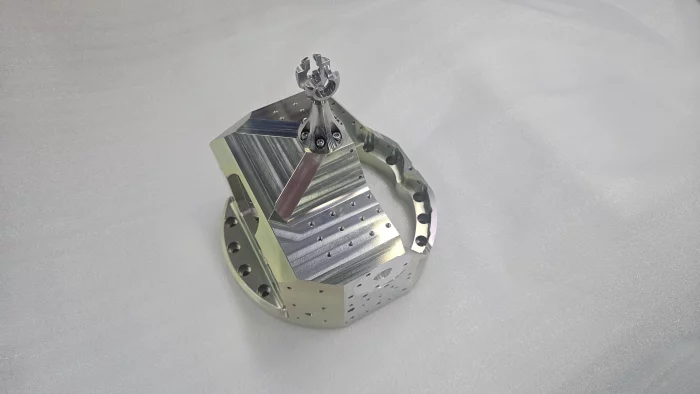
Dae Young M.Tech. Co., Ltd.
Gimbal Housing
A gimbal housing is a component that stabilizes and rotates the seeker of a guided weapon. It helps ensure the seeker can accurately aim at the target at all times, regardless of the guided weapon's movement.