한국어로 페이지 보기
Seoul ADEX 2025 Digital Directory
Plan your trip to Seoul ADEX 2025 using our state of the art Digital Directory
Register in seconds with just your email


Directory Features
To help you at the show
In-depth Exhibitor Profiles
Each exhibitor can add as many products and services as they wish, with in-depth information and specifications. This allows buyers to find what they want easily.
Self Provisioning for Exhibitors
Each exhibitor has full control of their content - to edit their company profile, upload products and enter staff details.
Plan your trip
Use the bookmarking and event planning tool to research the companies you would like to visit and the products you are interested in finding. You will be able to locate all of your saved companies on our floorplan
Advanced Search
Utilize our advanced search function to quickly locate products, people, and companies. Our state-of-the-art technology thoroughly scans all exhibitor information, delivering precise and relevant results
Interactive Floorplan
Navigate the show effortlessly with our directory. Use the floorplan to locate companies you want to visit and to find your way to onsite restaurants, toilets and site entrances and exits.
On-platform Messaging
Reach out to exhibitors and visitors directly on our platform to set up meetings, or request more information.
Some of our latest content
Companies, Products, News, Events
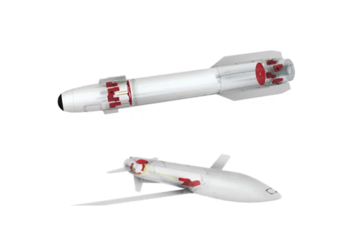
Moog - Space and Defense Group
Missile Systems
Moog designs and integrates highly innovative steering solutions that enable the precise accuracy of the world's best tactical missiles, guided projectiles and launch platforms.
Having produced and delivered well over one million systems for dozens of high profile platforms, customers appreciate our operational excellence value proposition: 100% quality delivered 100% on-time.
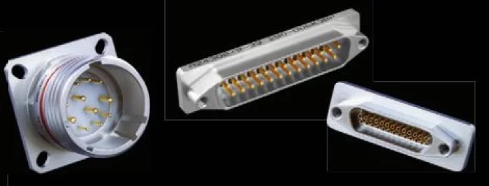
Glenair
Hermetic Connectors
Hermetic connectors are a special class of sealed Mil /Aero interconnect that incorporates glass-to-metal or other highly-engineered sealing technology. Hermetic seal connectors are specified for applications as divergent as submarines and orbiting satellites. They are deployed to resist moisture ingress in underground applications and to withstand pressure differentials in vacuum chambers, laboratory equipment and commercial and military aircraft.
Hermetic seal connectors, such as the MIL-DTL-38999 Series I, II, III and IV supplied by Glenair, are principally designed for use in military aerospace — in fact, the sealing requirement for connector hermeticity was originally driven by military electronic applications. But the products are equally at home in commercial applications such as oil-patch, logging equipment or medical devices.

MKS Ophir
Introducing SWIR & NIR 25-250mm f/5.5 (NFOV) f/4 (WFOV): Low-SWaP, LR, for 5µm & 10µm SXGA detectors
The SWIR & NIR 25-250mm f/5.5 (NFOV) f/4.0 (WFOV) continuous zoom lens is a first to market low-Size, Weight, and Power (SWaP), compact lens, for the newly introduced 5μm SXGA, as well as for 10μm SXGA, and 15μm VGA SWIR detectors.
The SWIR & NIR zoom lens employs a unique mechanical and optical design, resulting in an all-around smaller and lighter unit with only 860gr in weight, and 224mm in length, making it approximately 60% lighter than similar existing SWIR lenses.
The SWIR lens is also chromatically corrected to support a broader short-wave IR wavelength regime from 0.7-1.7μm and operates with minimal distortion.
The SWIR & NIR 25-250mm f/5.5 (NFOV) f/4.0 (WFOV) continuous zoom lens presents an unrivaled combination of SWaP capabilities, detection range exceeding 26km.
Product features:
• Continuous zoom in the 0.7-1.7μm SWIR regime
• Designed for 5μm, 10μm SXGA & 15μm VGA SWIR detectors
• Lightweight (<860 gr)
• Detection range >26 km
• Enables laser-line detection
_700.webp)
Britestone CO. , LTD.
Distributing all kind of semiconductor for Aerospace and defense
With an AS9120-certified logistics system and strong semiconductor expertise, we are tailored to support defense and aerospace customers, where small-volume, high-mix requirements, long life cycles, and unpredictable demand are common.
Beyond semiconductor components, we also provide electronic instruments and software solutions, serving as a total solution provider.

View page in English


디렉터리 기능
전시회 도우미
In-depth Exhibitor Profiles
Each exhibitor can add as many products and services as they wish, with in-depth information and specifications. This allows buyers to find what they want easily.
Self Provisioning for Exhibitors
Each exhibitor has full control of their content - to edit their company profile, upload products and enter staff details.
방문 계획 수립
북마크 도구와 이벤트 플래너를 사용해 방문하고자 하는 기업과 관심 있는 제품을 검색하세요. 저장한 모든 항목을 조회할 수 있습니다
고급 검색
고급 검색 기능을 사용하여 상품, 인물, 기업의 위치를 빠르게 조회할 수 있습니다. 최첨단 기술을 통해 모든 참가사의 정보를 철저히 스캔하여 세밀하고 관련성 있는 정보를 제공합니다
상호작용 가능 평면도
디렉터리를 사용해 전시회를 손쉽게 둘러보세요. 방문하고자 하는 기업의 위치와, 행사장 내 식당, 화장실, 출입구를 평면도에서 찾을 수 있습니다.
플랫폼 내 메시지
플랫폼 상의 전시 참가사와 관람객에게 직접 연락하여 미팅을 신청하거나 추가 정보를 요청하세요.
최신 콘텐츠
기업, 상품, 뉴스, 이벤트
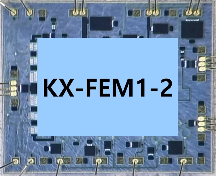
K-PA Inc.
KX-FEM1-2
Key Features
- Frequency Range: 8.5 - 10GHz
- RX Noise Figure: 3.0dB
- RX Small Signal Gain: 21 dB
- TX Small Signal Gain: 27dB
- TX High Pout: 39dBm
- TX High PAE: 37%
Chip size: 2.9x2.5x0.1mm
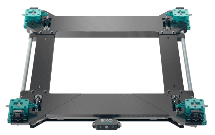
Exolaunch
Quadro Versa
Quadro Versa expands the capabilities of Exolaunch's microsatellite separation systems with a four-point offering tailored to satellites weighing up to 1000 kg and flying on SpaceX Rideshare plates. Versa has been designed for compatibility with the SpaceX four-point interfaces, and it is easily scalable to any size from 24”x24” up to 40”x40”. Larger satellites over 1000 kg and with larger footprints are also served by Versa, which offers unrivaled strength, stiffness and reliability for four-point satellites of any size.
Integrated Procurement Technologies
Company Background
Integrated Procurement Technologies (IPT) is a leading aerospace and military distributor and worldwide supplier of OEM parts and equipment. We specialize in aftermarket and new business solutions for our customers and OEM partners. We are experts in simplifying and expanding the global marketplace.
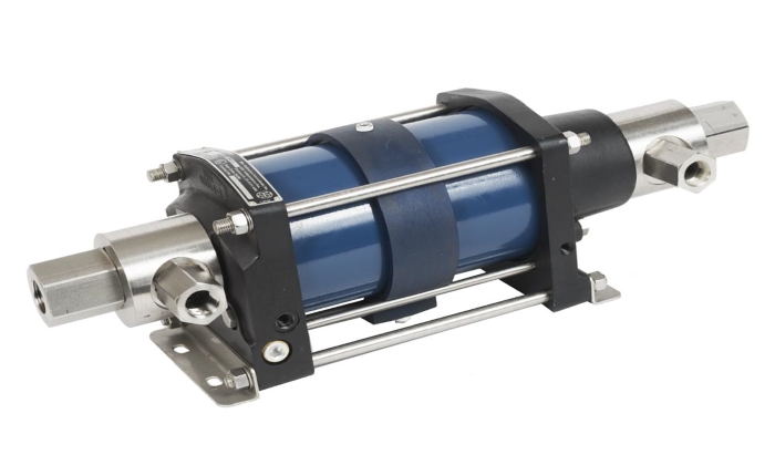
Hydraulics International Inc.
Hydraulics International Pump
Description