
 Digital Directory
한국어로 페이지 보기
Seoul ADEX 2025 Digital Directory
Plan your trip to Seoul ADEX 2025 using our state of the art Digital Directory
Register in seconds with just your email




Directory Features
To help you at the show
In-depth Exhibitor Profiles
Each exhibitor can add as many products and services as they wish, with in-depth information and specifications. This allows buyers to find what they want easily.
Self Provisioning for Exhibitors
Each exhibitor has full control of their content - to edit their company profile, upload products and enter staff details.
Plan your trip
Use the bookmarking and event planning tool to research the companies you would like to visit and the products you are interested in finding. You will be able to locate all of your saved companies on our floorplan
Advanced Search
Utilize our advanced search function to quickly locate products, people, and companies. Our state-of-the-art technology thoroughly scans all exhibitor information, delivering precise and relevant results
Interactive Floorplan
Navigate the show effortlessly with our directory. Use the floorplan to locate companies you want to visit and to find your way to onsite restaurants, toilets and site entrances and exits.
On-platform Messaging
Reach out to exhibitors and visitors directly on our platform to set up meetings, or request more information.
Some of our latest content
Companies, Products, News, Events
_700.webp)
HANGIL C&C. Co. Ltd
PROJECTS
Providing comprehensive training in the defense/aviation field and comprehensive logistics support system solution
[CBT/LCMS]
Analysis and application of ISD development methodology, 2D/3D modeling and animation production, application of OSMU (One Source Multi Use), application of SCORM standard for reuse and interoperability, development of CAI authoring tool
[AR/VR]
More than 100 multiple connections, omnidirectional interaction, high-precision content and processing engine, multi-platform support
[TIMS]
Pilot/mechanic training management, e-government framework, application of training history/grade/learning evaluation management function, development of other system linkage functions (C4I, DELLIS-F)
[Training Equipment]
Aerodynamic model development and HOST SW development, in-house development of image generator and data base production, aircraft aviation/navigation/system simulation and system design/integration and testing
[Avionics & ETS]
Embedded LRU and driver development, mission training, virtual radar/EO development, aircraft interworking and test evaluation
[Comprehensive Logistics Support]
Possessing ILS development capability, development of ground support equipment, mobile dehumidifier, aircraft MRO
[Motion/Control Reaction Force/Vibration System]
Provides motion, control reaction force, and vibration system for simulator system integration
_700.webp)
Telcom International
Amphenol RF
Amphenol RF is the world's largest manufacturer of coaxial connectors used in radio frequency, microwave, and data transmission system applications. Headquartered in Danbury, Connecticut, USA, Amphenol RF has global sales, marketing, and manufacturing facilities in North America, Asia, and Europe. Its connectors, adapters, cable assemblies, and other RF and microwave solutions are widely used in a wide range of industries and applications, including automotive, broadband broadcasting, instrumentation, medical, and defense wireless equipment. Amphenol RF's industry-leading manufacturing technology and process control enable it to produce high-quality coaxial connectors and cable assemblies at high volumes.
_700.webp)
ETL Co., Ltd.
ION 1
Features
- Excellent absorption performance (Maximum: -25 dB, Average: -10 dB)
- Frequency tuning capability available
- Easily applicable to complex structures, including curved surfaces, gaps, and protrusions
- Low dry density and specific gravity
- Reduced number of coating layers, improving work efficiency
- Passed environmental resistance and durability tests by the operational conditions of weapon systems
- Electrical insulation properties to minimize the effects of lightning
_700.webp)
Korea Aerospace Industries
LAH
Contribute the Enhancement of Armed Forces with
Continuous Technology Development
Designed for replacing the Republic of Korea Army(RoKA)’s aged attack helicopter (500MD, AH-1S), the LAH(Light Armed Helicopter) Project is the one that aims to develop a cutting-edge armed helicopter suitable for the modern battlefield.
Through the synergy of maximizing commonality in subsystems and parts with LCH(Light Civil Helicopter), KAI will reduce the development, production, and sustainment cost ultimately to be a bridgehead for a global helicopter market.
The first flight of LAH was successfully conducted in 2019. KAI aims to complete the development of LAH in 2023.
View page in English




디렉터리 기능
전시회 도우미
In-depth Exhibitor Profiles
Each exhibitor can add as many products and services as they wish, with in-depth information and specifications. This allows buyers to find what they want easily.
Self Provisioning for Exhibitors
Each exhibitor has full control of their content - to edit their company profile, upload products and enter staff details.
방문 계획 수립
북마크 도구와 이벤트 플래너를 사용해 방문하고자 하는 기업과 관심 있는 제품을 검색하세요. 저장한 모든 항목을 조회할 수 있습니다
고급 검색
고급 검색 기능을 사용하여 상품, 인물, 기업의 위치를 빠르게 조회할 수 있습니다. 최첨단 기술을 통해 모든 참가사의 정보를 철저히 스캔하여 세밀하고 관련성 있는 정보를 제공합니다
상호작용 가능 평면도
디렉터리를 사용해 전시회를 손쉽게 둘러보세요. 방문하고자 하는 기업의 위치와, 행사장 내 식당, 화장실, 출입구를 평면도에서 찾을 수 있습니다.
플랫폼 내 메시지
플랫폼 상의 전시 참가사와 관람객에게 직접 연락하여 미팅을 신청하거나 추가 정보를 요청하세요.
최신 콘텐츠
기업, 상품, 뉴스, 이벤트
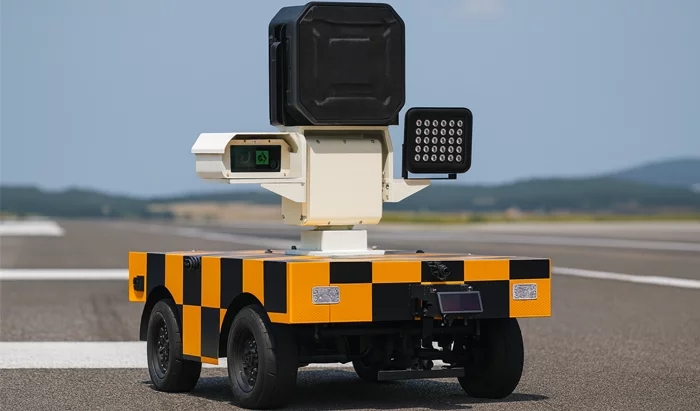
SkyAutoNet
Autonomous Bird-Repelling Robot
# Key Features
- Map Generation and No-Drive Zone Setting in Airports
> Airport map/sensor fusion-based localization function
> Function for defining main movement and standby areas
> No-drive zone setting
- Optimal Path Autonomous Driving Function
> Destination-based optimal path navigation
> Speed limit settings by path and area
> Real-time location monitoring
> Obstacle detection and immediate response
> Driving on diverse road surfaces within designated areas
- Real-Time Bird Detection and Bird Position/Direction Prediction
> Real-time bird detection
> Support for approximate bird position/direction prediction based on object detection algorithms
> Updating of approximate bird position/direction prediction based on flock detection
- Effective Bird Deterrence Reflecting Bird Characteristics
> Playback of diverse (randomized) acoustic patterns
- Real-Time Communication with Operator and Manual Control Function
> Monitoring console (PC) provides real-time bird detection status and history
> Display of approximate bird position/direction predictions on a map
> Real-time video data sharing
> Remote manual control
- Smart Charging Function
> Automatic return and charging when mission is complete or battery is low
_700.webp)
TelePIX Co., Ltd.
BlueBON
The world’s first satellite dedicated to blue carbon monitoring, launched in January 2025. Equipped with an AI-powered onboard processor, BlueBON processes electro-optical data directly in orbit, reducing latency and eliminating the need for energy-intensive ground-based processing. This establishes a new model for sustainable, application-driven EO missions.
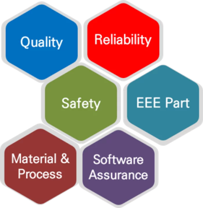
MID Co. Ltd
Product Assurance Consulting
Product Assurance Consulting :
1. The recent paradigm shift in newspace has expanded opportunities for new companies to enter the space industry.
2. Space product warranties pose a barrier to new entrants into the space industry.
3. MID has developed various programs to provide product warranty consulting services to new entrants to the space industry and offer customized services to our clients.
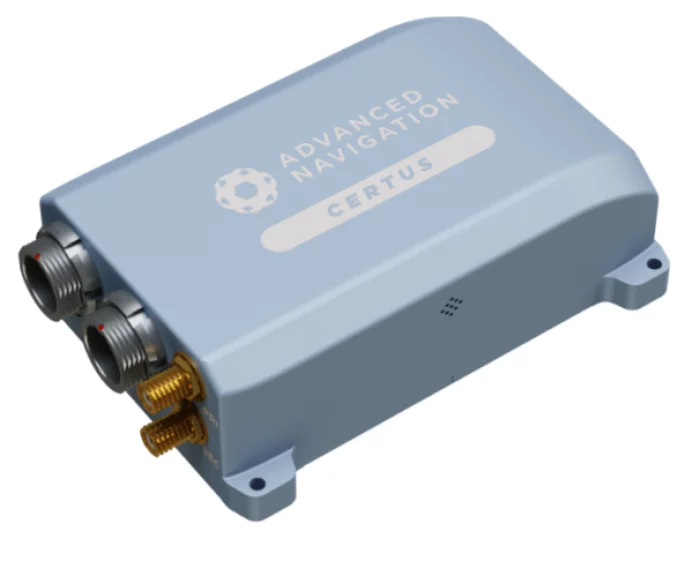
Ultronics
Certus
AI Navigation Algorithm
Certus features Advanced Navigation’s revolutionary AI neural network sensor fusion algorithm. It was designed for control applications and has a high level of health monitoring and instability prevention to ensure stable and reliable data.
High-Performance MEMS
Certus contains high performance MEMS sensors that are put through Advanced Navigation’s intensive 8 hour temperature calibration process. This provides the highest accuracy possible from this sensor class and outputs consistent accuracy over the full temperature range from -40°C to 85°C.
Dual Antenna RTK GNSS
Certus contains a dual frequency RTK GNSS receiver that provides up to 1 cm accuracy positioning and supports all of the current and future satellite navigation systems, including GPS, GLONASS, GALILEO, BeiDou and QZSS. Dual antenna heading provides high accuracy heading that is not impacted by magnetic interference and has no motion requirements.
Time Synchronization
Certus contains a GNSS disciplined oscillator that can act as the primary time source within a distributed time system, enabling access to ultra-accurate system time using PTP or NTP network time sync. Certus also has a high-accuracy 1PPS and frequency output.
Multi-Protocol Support
Certus features multiple interfaces including Ethernet, CAN, RS232, RS422 and GPIOs. Certus supports all the industry standard protocols including NMEA 0183, NMEA 2000, TSS, PASHR, Simrad as well as a wide variety of proprietary protocols. It features a rich web UI and 256GB of internal logging.