한국어로 페이지 보기
Seoul ADEX 2025 Digital Directory
Plan your trip to Seoul ADEX 2025 using our state of the art Digital Directory
Register in seconds with just your email


Directory Features
To help you at the show
In-depth Exhibitor Profiles
Each exhibitor can add as many products and services as they wish, with in-depth information and specifications. This allows buyers to find what they want easily.
Self Provisioning for Exhibitors
Each exhibitor has full control of their content - to edit their company profile, upload products and enter staff details.
Plan your trip
Use the bookmarking and event planning tool to research the companies you would like to visit and the products you are interested in finding. You will be able to locate all of your saved companies on our floorplan
Advanced Search
Utilize our advanced search function to quickly locate products, people, and companies. Our state-of-the-art technology thoroughly scans all exhibitor information, delivering precise and relevant results
Interactive Floorplan
Navigate the show effortlessly with our directory. Use the floorplan to locate companies you want to visit and to find your way to onsite restaurants, toilets and site entrances and exits.
On-platform Messaging
Reach out to exhibitors and visitors directly on our platform to set up meetings, or request more information.
Some of our latest content
Companies, Products, News, Events
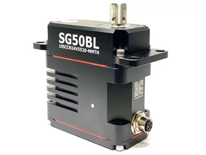
hitecrcd Korea
SG50BL-CAN-24V-CIRCULAR-CONN
Capable of a wide 18~32-volt operating range, the robust SG50BL is designed with a high-performance brushless motor, magnetic encoder, and durable, hardened steel gears. It includes CAN 2.0 A/B or DroneCAN (formerly UAVCAN) control options with 360 degrees and multi-turn proportional rotation. Its waterproof 50mm case and monster torque range bring the power and durability required for robotic, automation and commercial applications requiring robust force, precision and installed durability.
#UAV #UAS #UAM #UGV #UUV #USV
.jpg)
Haigh-Farr, Inc.
Antennas
Haigh-Farr specializes in the design, manufacture, and testing (electrical and environmental) of conformal and non-conformal antennas. As a leader in the aerospace industry, our antennas are found on the latest high-performance airborne and space vehicles. Haigh-Farr is well known for its reliable, high-quality range of customizable and off-the-shelf solutions.
_700.webp)
Everysim Inc.
EveryDrone
EveryDrone is a web-based tool for developing high-performance drones. It enables 3D model creation, virtual wind tunnel testing(CFD), and structural analysis, all without software installation.
Even without prior simulation knowledge, anyone can follow the workflow to easily complete simulations.
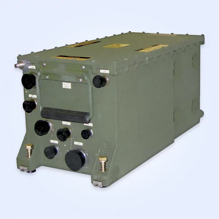
EMCORE
PNU / UPNU Position & Navigation Unit / Universal Position & Navigation Unit
The Improved Fire Control System (IFCS) PNU / Universal Fire Control System (UFCS) UPNU family represents a true state-of-the-art system approach. Its design features permit ready adaptation and/or optimization to any current or future weapon system or sensor requiring precision pointing and positioning.
The PNU / UPNU and its variants point the way for the future direction of the land navigation systems. Utilizing advanced sensors, electronics, software and aiding (GPS and odometer), the PNU / UPNU family delivers precisely what the Army of tomorrow needs — a system designed to remain operationally effective and affordable to support well into the future.
Features
High-performance RLG-34 ring laser gyros
Common architecture and components (Paladin, PIM, Firefinder, IPADS)
Embedded 12-channel Selective Availability Anti-Spoofing Module (SAASM)
Impervious to jamming (inertial mode)
Resistant to jamming (GPS-aided mode)
Combat-proven
Embedded Built-In Test (BIT)
High reliability MTBF, low mean time to repair (MTTR)
No periodic calibration required
Applications
Multiple Launch Rocket System (MLRS)
High-Mobility Artillery Rocket System (HIMARS)
Pointing and position location

View page in English


디렉터리 기능
전시회 도우미
In-depth Exhibitor Profiles
Each exhibitor can add as many products and services as they wish, with in-depth information and specifications. This allows buyers to find what they want easily.
Self Provisioning for Exhibitors
Each exhibitor has full control of their content - to edit their company profile, upload products and enter staff details.
방문 계획 수립
북마크 도구와 이벤트 플래너를 사용해 방문하고자 하는 기업과 관심 있는 제품을 검색하세요. 저장한 모든 항목을 조회할 수 있습니다
고급 검색
고급 검색 기능을 사용하여 상품, 인물, 기업의 위치를 빠르게 조회할 수 있습니다. 최첨단 기술을 통해 모든 참가사의 정보를 철저히 스캔하여 세밀하고 관련성 있는 정보를 제공합니다
상호작용 가능 평면도
디렉터리를 사용해 전시회를 손쉽게 둘러보세요. 방문하고자 하는 기업의 위치와, 행사장 내 식당, 화장실, 출입구를 평면도에서 찾을 수 있습니다.
플랫폼 내 메시지
플랫폼 상의 전시 참가사와 관람객에게 직접 연락하여 미팅을 신청하거나 추가 정보를 요청하세요.
최신 콘텐츠
기업, 상품, 뉴스, 이벤트
Ho-Ho-Kus, Inc.
Cargo Systems
Our cargo system product line includes brackets, buckles, rollers and other hardware.
_700.webp)
MTG
Dual-Ridged Horn
Features
● Wideband Frequency Range of 2.0~18.0GHz
● Rigid Construction with AL Brazing
● Monotonic Beam Shape, No Beam Split
● Optimized Gain Ripple and VSWR
Applications
● General Purpose TX/RX Antenna
● EMC Testing
● TX/RX Antenna for EW Testing
● Wideband TX Antenna for Anechoic Chamber
 withoutbase_700.webp)
Chelton Limited
DACU4c
The system is designed to maximise installation flexibility, through optional power and diagnostics data over RF
(permitting the use of a single cable), and a highly reconfigurable baseplate to allow the mounting holes and connector type/ position to be tailored to the target platform. Use of Chelton’s established and field-tested
GNSS Anti-Jam core firmware provides a high degree of protection against complex threat scenarios and in highly dynamic environments. A software definable core allows future upgradeable ‘Signal Intelligence Apps’ to be hosted, providing the user with situational awareness of the battlefield environment and allows feedback into mission planning activities.
ICEYE
Tasking
GAIN CRITICAL CLARITY WITH SATELLITE TASKING
Task ICEYE SAR satellites to access groundbreaking data on any location on Earth – day or night and in any weather. The process is simple and images are usually delivered within 24 to 48 hours of your initial request.
ORDERING SAR DATA – MADE SIMPLE
We believe access to reliable and timely SAR Earth observation data should be available to all, so we provide access options designed to meet your specific mission needs and collection timeframes. The process begins with defining your area of interest, revisit frequency and other parameters. The first images are usually acquired, downlinked, decoded and processed within 24 hours of the initial request and delivered within 8 hours after that.