한국어로 페이지 보기
Seoul ADEX 2025 Digital Directory
Plan your trip to Seoul ADEX 2025 using our state of the art Digital Directory
Register in seconds with just your email


Directory Features
To help you at the show
In-depth Exhibitor Profiles
Each exhibitor can add as many products and services as they wish, with in-depth information and specifications. This allows buyers to find what they want easily.
Self Provisioning for Exhibitors
Each exhibitor has full control of their content - to edit their company profile, upload products and enter staff details.
Plan your trip
Use the bookmarking and event planning tool to research the companies you would like to visit and the products you are interested in finding. You will be able to locate all of your saved companies on our floorplan
Advanced Search
Utilize our advanced search function to quickly locate products, people, and companies. Our state-of-the-art technology thoroughly scans all exhibitor information, delivering precise and relevant results
Interactive Floorplan
Navigate the show effortlessly with our directory. Use the floorplan to locate companies you want to visit and to find your way to onsite restaurants, toilets and site entrances and exits.
On-platform Messaging
Reach out to exhibitors and visitors directly on our platform to set up meetings, or request more information.
Some of our latest content
Companies, Products, News, Events
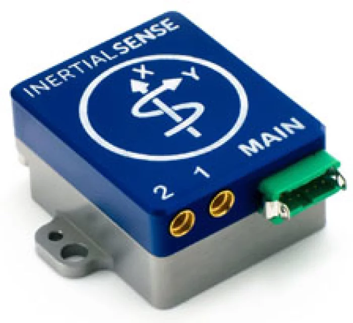
Ultronics
IMX-5-DUAL
The IMX-5 delivers Tactical Grade Inertial performance powered by TWO of the most powerful GNSS receivers on the market. Inside the aluminum enclosure, this sensor is prepared to take you through difficult terrain. The IMX-5 provides sensor fusion for roll, pitch, magnetic heading, velocity, RTK precision position and Dual GNSS Compass Heading.
Features
Tactical Grade IMU
Dual Onboard Multi-Frequency (L1/L2) GNSS Receivers
Dual GNSS Compassing
RTK Centimeter Level Precision
Rugged IP40 Aluminum Enclosure
Gyro: 1.5 °/hr Bias Instability, 0.16 °/√hr ARW
Accel: 19 µg Bias Instability, 0.02 m/s/√hr VRW
0.04° Dynamic Roll/Pitch
0.13° Dynamic Heading
Fast Integration with SDK and Example Software
Data Logging (SDK and Application Software)

HYTEC INTER KOREA Co., Ltd
LLC-4000ME
LLC-4000 is a cutting-edge 4K low-latency video encoder/decoder purpose-built for tactical operations, reconnaissance, and situational awareness in demanding environments.
It delivers reliable real-time video transmission over narrow-bandwidth satellite links and tactical radio systems, enabling uninterrupted communication during critical missions.
Engineered with a compact form factor and advanced compression technology, the LLC-4000 is well-suited for remote and mobile deployments where bandwidth is limited. Proven in operational use, the system has been successfully deployed by units of the Japan Ground Self-Defence Force, including amphibious rapid deployment and communications brigades, supporting a wide range of military field operations.
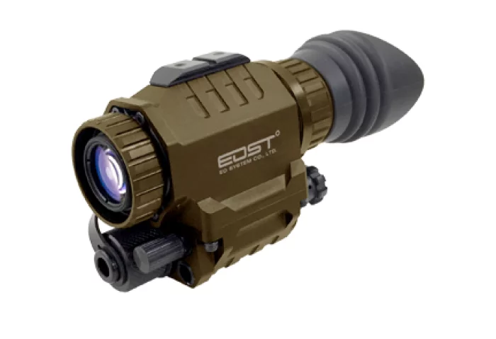
EO System
Night Vision Goggle
NVS, Night Vision Scope is designed for individual soldiers and law enforcement personnel which has been already in operation all around the world.
This device gives soldiers and law enforcement the versatility they need to engage in operations with optimum efficiency.
_700.webp)
Invictum
Pulse-80
The Pulse-80 is a premium tactical-grade MEMS IMU, engineered for applications demanding compact size and minimal weight without any compromise on performance.

View page in English


디렉터리 기능
전시회 도우미
In-depth Exhibitor Profiles
Each exhibitor can add as many products and services as they wish, with in-depth information and specifications. This allows buyers to find what they want easily.
Self Provisioning for Exhibitors
Each exhibitor has full control of their content - to edit their company profile, upload products and enter staff details.
방문 계획 수립
북마크 도구와 이벤트 플래너를 사용해 방문하고자 하는 기업과 관심 있는 제품을 검색하세요. 저장한 모든 항목을 조회할 수 있습니다
고급 검색
고급 검색 기능을 사용하여 상품, 인물, 기업의 위치를 빠르게 조회할 수 있습니다. 최첨단 기술을 통해 모든 참가사의 정보를 철저히 스캔하여 세밀하고 관련성 있는 정보를 제공합니다
상호작용 가능 평면도
디렉터리를 사용해 전시회를 손쉽게 둘러보세요. 방문하고자 하는 기업의 위치와, 행사장 내 식당, 화장실, 출입구를 평면도에서 찾을 수 있습니다.
플랫폼 내 메시지
플랫폼 상의 전시 참가사와 관람객에게 직접 연락하여 미팅을 신청하거나 추가 정보를 요청하세요.
최신 콘텐츠
기업, 상품, 뉴스, 이벤트
NIDV
Trade promotion
The NIDV supports its members in both national and international markets in as many ways as possible. From participation in international projects, international trade fair visits to programmes with government support. You can find more information about these initiatives below.
ZYX Technology
DIVE
DIVE (Digital Interactive Virtual Environment) is a GIS-based smart construction management platform jointly developed by ZYX Technology and Korea Expressway Corporation. Designed to meet the growing demand for intelligent infrastructure solutions, DIVE provides real-time integration, monitoring, and analysis of all location-based construction data.
By consolidating diverse sources such as design drawings, land maps, aerial imagery, BIM data, drone footage, and CCTV into a single platform, DIVE enables comprehensive, on-site visibility and control. From large-scale infrastructure to complex tunnel projects, all key information can be accessed and compared in real time, allowing for smarter, faster, and more accurate decision-making.
The main dashboard provides a live overview of each project site, including tasks, equipment, workers, events, and safety issues. With its daily work management feature, site managers can view exact personnel and equipment allocations for each zone, improving efficiency and minimizing risk.
DIVE also supports seamless integration with tunnel monitoring systems, offering real-time access to excavation status, geotechnical sensors, and worker presence inside the tunnel. This ensures enhanced safety and process transparency in high-risk environments.
Drone integration further strengthens site management by providing up-to-date aerial visuals, reducing blind spots and enabling rapid response to field changes. In addition, the platform links design drawings with cadastral maps to streamline permitting, track construction progress, and manage change orders with geographic accuracy.
Whether you're building roads, tunnels, or complex infrastructure, DIVE empowers construction teams with a powerful digital environment to manage the entire project lifecycle.
_700.webp)
Preneu Co.,Ltd.
PANDION Q650 : Multipurpose Drone for Specialized Missions
The PANDION Q650 is a versatile military and industrial drone, designed for easy maintenance and adaptability. Featuring a multi-mount bracket, it allows users to customize payloads such as speakers, searchlights, and LiDAR sensors to meet specific operational needs.
Built for rugged environments, it is rated IP43 for water and dust resistance, ensuring durability in harsh conditions. The drone can perform missions with a flight time of approximately 40 minutes.
Application : Day/Night Reconnaissance, Warning Sign Delivery, Automatic Patrol Mission, High-Res Photo/Video, Package Delivery (Under 1Kg)
PACE Aerospace Engineering and Information Technology GmbH
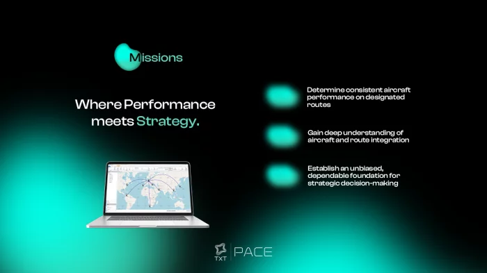
Missions: for Route and Aircraft Performance Analysis
Missions is the only commercially available analysis tool which brings together aircraft definition, aircraft performance and cost investigations in a single environment and delivers reliable projections of key metrics such as payload capacity, maximum range and direct operating cost. Excellent runtime performance and the integrated analysis environment ensure fast results even when dealing with large route networks.