한국어로 페이지 보기
Seoul ADEX 2025 Digital Directory
Plan your trip to Seoul ADEX 2025 using our state of the art Digital Directory
Register in seconds with just your email


Directory Features
To help you at the show
In-depth Exhibitor Profiles
Each exhibitor can add as many products and services as they wish, with in-depth information and specifications. This allows buyers to find what they want easily.
Self Provisioning for Exhibitors
Each exhibitor has full control of their content - to edit their company profile, upload products and enter staff details.
Plan your trip
Use the bookmarking and event planning tool to research the companies you would like to visit and the products you are interested in finding. You will be able to locate all of your saved companies on our floorplan
Advanced Search
Utilize our advanced search function to quickly locate products, people, and companies. Our state-of-the-art technology thoroughly scans all exhibitor information, delivering precise and relevant results
Interactive Floorplan
Navigate the show effortlessly with our directory. Use the floorplan to locate companies you want to visit and to find your way to onsite restaurants, toilets and site entrances and exits.
On-platform Messaging
Reach out to exhibitors and visitors directly on our platform to set up meetings, or request more information.
Some of our latest content
Companies, Products, News, Events
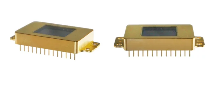
i3system, inc.
InGaAs(SWIR)
Specification
Array Format : 1280 × 1024
Pixel pitch : 10㎛
Spectral range : 0.9㎛ ~ 1.7㎛ (SWIR)
Operability : ≥ 99.5%
Quantum Efficiency : 70% @ 1550nm
Application
Near-infrared Imaging
Imaging Spectroscopy
Surveillance
Medical Science and Biology
Astronomy and Scientific
Material inspection
Food inspection
Forgery detection
Invest Quebec
Spacebridge
30년+ 위성통신 경험을 바탕으로 VSAT 허브/모뎀과 광대역 SATCOM을 제공하며, 전술 방산·정부, 이동통신 백홀, 방송 등 다양한 미션 요구에 최적화된 솔루션을 제공합니다.
_700.webp)
Everysim Inc.
EveryDrone
EveryDrone is a web-based tool for developing high-performance drones. It enables 3D model creation, virtual wind tunnel testing(CFD), and structural analysis, all without software installation.
Even without prior simulation knowledge, anyone can follow the workflow to easily complete simulations.
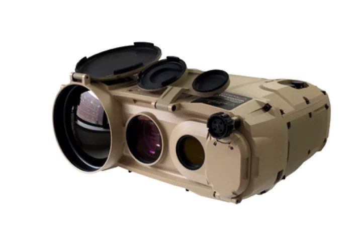
EO System
Multi-Function Observation Device
THETIS-M2 is a multifunction thermal imaging system that provides soldiers with an advanced, light weight solution for day and night reconnaissance, surveillance and forward observation purposes.
It also gives the blue forces a real-time target acquisition and target coordinate calculation capabilities.
Thermal Camera + Direct View Optic +Laser Range Finder + Digital Magnetic Compass + GPS

View page in English


디렉터리 기능
전시회 도우미
In-depth Exhibitor Profiles
Each exhibitor can add as many products and services as they wish, with in-depth information and specifications. This allows buyers to find what they want easily.
Self Provisioning for Exhibitors
Each exhibitor has full control of their content - to edit their company profile, upload products and enter staff details.
방문 계획 수립
북마크 도구와 이벤트 플래너를 사용해 방문하고자 하는 기업과 관심 있는 제품을 검색하세요. 저장한 모든 항목을 조회할 수 있습니다
고급 검색
고급 검색 기능을 사용하여 상품, 인물, 기업의 위치를 빠르게 조회할 수 있습니다. 최첨단 기술을 통해 모든 참가사의 정보를 철저히 스캔하여 세밀하고 관련성 있는 정보를 제공합니다
상호작용 가능 평면도
디렉터리를 사용해 전시회를 손쉽게 둘러보세요. 방문하고자 하는 기업의 위치와, 행사장 내 식당, 화장실, 출입구를 평면도에서 찾을 수 있습니다.
플랫폼 내 메시지
플랫폼 상의 전시 참가사와 관람객에게 직접 연락하여 미팅을 신청하거나 추가 정보를 요청하세요.
최신 콘텐츠
기업, 상품, 뉴스, 이벤트
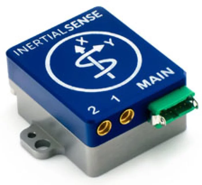
Ultronics
IMX-5-DUAL
The IMX-5 delivers Tactical Grade Inertial performance powered by TWO of the most powerful GNSS receivers on the market. Inside the aluminum enclosure, this sensor is prepared to take you through difficult terrain. The IMX-5 provides sensor fusion for roll, pitch, magnetic heading, velocity, RTK precision position and Dual GNSS Compass Heading.
Features
Tactical Grade IMU
Dual Onboard Multi-Frequency (L1/L2) GNSS Receivers
Dual GNSS Compassing
RTK Centimeter Level Precision
Rugged IP40 Aluminum Enclosure
Gyro: 1.5 °/hr Bias Instability, 0.16 °/√hr ARW
Accel: 19 µg Bias Instability, 0.02 m/s/√hr VRW
0.04° Dynamic Roll/Pitch
0.13° Dynamic Heading
Fast Integration with SDK and Example Software
Data Logging (SDK and Application Software)
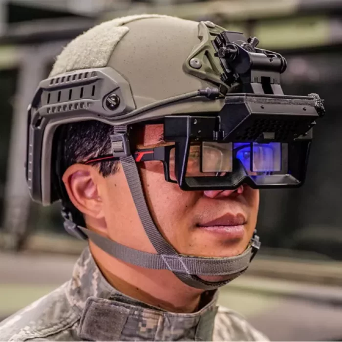
Honeywell Aerospace Technologies
Honeywell 360 Display
Honeywell 360 Display for Aviation
The aviation version of the display is a wearable visor that uses augmented reality to provide civilian or military pilots with a high-resolution 360-degree view that seamlessly matches the view outside the cockpit. It also provides traffic callouts and flight instrumentation in the pilot’s field of view, which makes the Honeywell 360 Display ideal for flying at night, in bad weather or in congested airspace. The display improves safety, pilot confidence and aircraft utility.
Honeywell 360 Display for Rugged Ground Vehicles
Operators of ruggedized vehicles can use the display to safely maneuver in low visibility or hazardous conditions. It improves overall situational awareness, reaction speed and survivability by increasing visibility and reducing the need to consult instruments in the vehicle. The lightweight head-worn display uses real-time outside high-resolution camera feeds to create a seamless mixed-reality view and provides operators sensor information within their immediate field of view.
_700.webp)
AIR COST CONTROL
Electro - mechanical devices
• Toggle switches
• Circuits breakers
• Illuminated push buttons
• Relays / Relays bases.
• Potentiometer.
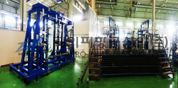
KP Aero Industries
A350 NLG-DOOR ASSEMBLY FIXTURE
For : Nose-Landing Gear Assembly Jig
A350 Project
4.8m (L) x 2.5m (W) x 3m (H )