한국어로 페이지 보기
Seoul ADEX 2025 Digital Directory
Plan your trip to Seoul ADEX 2025 using our state of the art Digital Directory
Register in seconds with just your email


Directory Features
To help you at the show
In-depth Exhibitor Profiles
Each exhibitor can add as many products and services as they wish, with in-depth information and specifications. This allows buyers to find what they want easily.
Self Provisioning for Exhibitors
Each exhibitor has full control of their content - to edit their company profile, upload products and enter staff details.
Plan your trip
Use the bookmarking and event planning tool to research the companies you would like to visit and the products you are interested in finding. You will be able to locate all of your saved companies on our floorplan
Advanced Search
Utilize our advanced search function to quickly locate products, people, and companies. Our state-of-the-art technology thoroughly scans all exhibitor information, delivering precise and relevant results
Interactive Floorplan
Navigate the show effortlessly with our directory. Use the floorplan to locate companies you want to visit and to find your way to onsite restaurants, toilets and site entrances and exits.
On-platform Messaging
Reach out to exhibitors and visitors directly on our platform to set up meetings, or request more information.
Some of our latest content
Companies, Products, News, Events

Conflux Technology
Gas-Gas
Heat Exchange
Additive manufacturing:
- allows highly efficient, compact recuperators with custom flow paths, maximizing energy recovery and reducing overall system emissions.
- charge air coolers enhance cooling performance with tailored airflow designs, reducing intake temperatures and boosting engine efficiency.
- delivers precise, space-efficient pre-coolers and heaters, ensuring optimized thermal response and energy efficiency for various industrial applications.

Honeywell International
How Airlines in Boston Will Screen Passengers' Skin Temperature
Air travelers will have temperatures checked quickly with technology As more people receive COVID-19 vaccines, travelers are itching to visit friends and family and take vacations again. Here's how airlines in one major U.S. airport will help keep passengers safe.
_700.webp)
Raionrobotics
RAIBO2
RAIBO2 is a quadrupedal robotic platform that uses four legs to navigate to designated locations, observe its surroundings.
Based on state-of-the-art robotic control technology, deep reinforcement learning enables highly dynamic, robust, and efficient locomotion.
Furthermore, the in-house integration of hardware and software facilitates energy and design optimization, while allowing for extensive customization.
_700.webp)
SAMBO MOTORS GROUP
B - 33x
A next-generation Advanced Air Mobility (AAM) aircraft currently under development, designed with a separable upper platform and lower mission module structure.
The interchangeable lower modules can be configured for passenger transport, cargo delivery, or reconnaissance missions, offering exceptional operational flexibility across various applications.
As a large-scale platform, it embodies the future of modular air mobility, enabling rapid mission conversion, efficient maintenance, and cost-effective operation for both urban and regional air mobility sectors.

View page in English


디렉터리 기능
전시회 도우미
In-depth Exhibitor Profiles
Each exhibitor can add as many products and services as they wish, with in-depth information and specifications. This allows buyers to find what they want easily.
Self Provisioning for Exhibitors
Each exhibitor has full control of their content - to edit their company profile, upload products and enter staff details.
방문 계획 수립
북마크 도구와 이벤트 플래너를 사용해 방문하고자 하는 기업과 관심 있는 제품을 검색하세요. 저장한 모든 항목을 조회할 수 있습니다
고급 검색
고급 검색 기능을 사용하여 상품, 인물, 기업의 위치를 빠르게 조회할 수 있습니다. 최첨단 기술을 통해 모든 참가사의 정보를 철저히 스캔하여 세밀하고 관련성 있는 정보를 제공합니다
상호작용 가능 평면도
디렉터리를 사용해 전시회를 손쉽게 둘러보세요. 방문하고자 하는 기업의 위치와, 행사장 내 식당, 화장실, 출입구를 평면도에서 찾을 수 있습니다.
플랫폼 내 메시지
플랫폼 상의 전시 참가사와 관람객에게 직접 연락하여 미팅을 신청하거나 추가 정보를 요청하세요.
최신 콘텐츠
기업, 상품, 뉴스, 이벤트
_700.webp)
Ray Service, A.S.
Manufacturing of Electromechanical Assemblies
Ray Service, headquartered in Staré Město, Czech Republic, is an international innovative manufacturer of cable harnesses, electromechanical assemblies, and electronic equipment. It is also a distributor and integrator of cable components and system products. More than 30 years of experience and intensive development have resulted in a strong, modern enterprise, a reliable and sought-after partner on an international level.
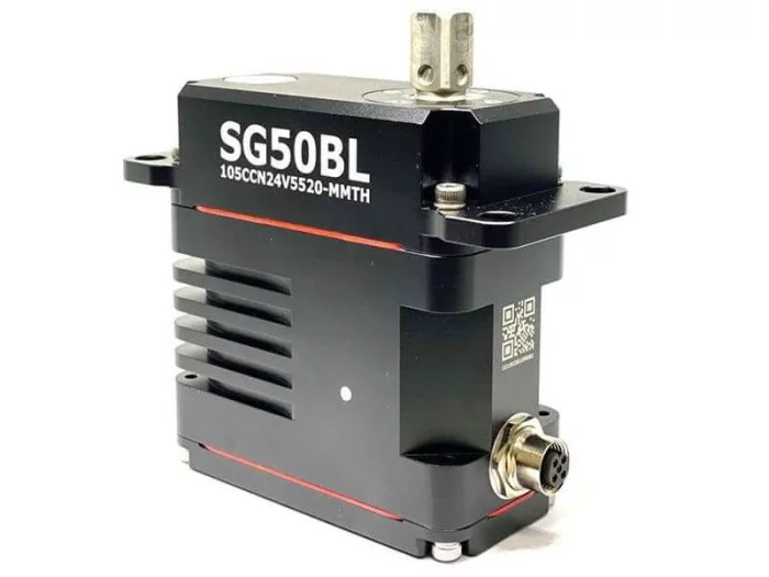
hitecrcd Korea
SG50BL-CAN-24V-CIRCULAR-CONN
Capable of a wide 18~32-volt operating range, the robust SG50BL is designed with a high-performance brushless motor, magnetic encoder, and durable, hardened steel gears. It includes CAN 2.0 A/B or DroneCAN (formerly UAVCAN) control options with 360 degrees and multi-turn proportional rotation. Its waterproof 50mm case and monster torque range bring the power and durability required for robotic, automation and commercial applications requiring robust force, precision and installed durability.
#UAV #UAS #UAM #UGV #UUV #USV
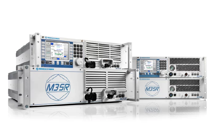
Rohde & Schwarz Korea Ltd.
R&S®M3SR 소프트웨어 정의 무전기 (VHF/UHF, HF)
R&S®M3SR은 민간, 방위, 해상 지-공-지 통신 솔루션을 위한 최신 고정식 무전기를 대표하는 기기입니다. 로데슈바르즈는 점차 엄격해지는 통신 요구사항에 대해 수년 간의 실무 경험을 기반으로 한 기술 개념으로 대응하고 있습니다. 무전기는 가장 엄격한 품질 측면을 충족하여 최대 RF 성능을 제공합니다.
이 고성능 소프트웨어 정의 무전기는 전 세계 보안 당국과 정부 조직에서 높은 평가를 받고 있습니다.
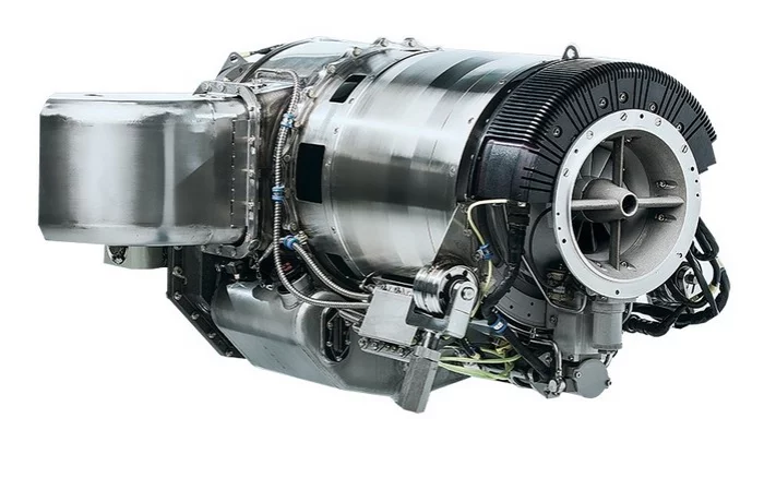
PBS GROUP
PBS TS100
The engine offers a take-off power of up to 180 kW (235 hp).
Excellent power-to-weight ratio.
Small installation dimensions.
Two outpu shaft speed configurations.
Stable operation at high and low temperatures.