한국어로 페이지 보기
Seoul ADEX 2025 Digital Directory
Plan your trip to Seoul ADEX 2025 using our state of the art Digital Directory
Register in seconds with just your email


Directory Features
To help you at the show
In-depth Exhibitor Profiles
Each exhibitor can add as many products and services as they wish, with in-depth information and specifications. This allows buyers to find what they want easily.
Self Provisioning for Exhibitors
Each exhibitor has full control of their content - to edit their company profile, upload products and enter staff details.
Plan your trip
Use the bookmarking and event planning tool to research the companies you would like to visit and the products you are interested in finding. You will be able to locate all of your saved companies on our floorplan
Advanced Search
Utilize our advanced search function to quickly locate products, people, and companies. Our state-of-the-art technology thoroughly scans all exhibitor information, delivering precise and relevant results
Interactive Floorplan
Navigate the show effortlessly with our directory. Use the floorplan to locate companies you want to visit and to find your way to onsite restaurants, toilets and site entrances and exits.
On-platform Messaging
Reach out to exhibitors and visitors directly on our platform to set up meetings, or request more information.
Some of our latest content
Companies, Products, News, Events
TECHSAN ENG
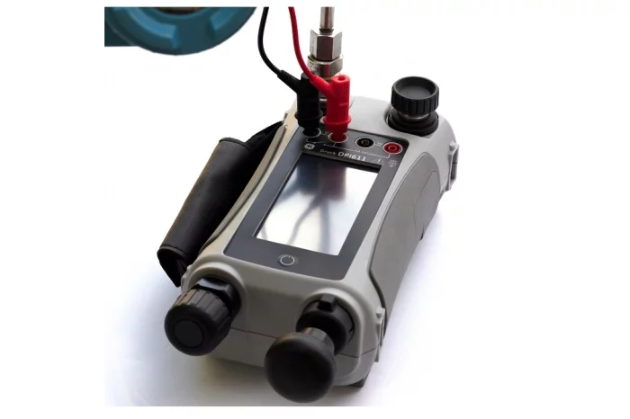
Pressure Sensor Test and Calibration Instrument DPI611
This fully self-contained pressure test and calibration system combines pressure generation, signal measurement, and loop power to deliver all the convenience of the Druck DPI 610/615, while being half the size, twice as accurate and easy to use.
The DPI 611 is the fourth generation of the DPI 600 family, first introduced in 1984.
The DPI 600 family revolutionized testing and calibration by providing all the tools for pressure generation and signal measurement in a stand-alone portable package. The DPI 600 soon became the flagship equipment of the industry and today it is simply known as "Druck".
Built on a technical legacy and more than 30 years of experience in pressure measurement and calibration, the DPI 611 offers all the convenience and reliability of a true "Druck", while delivering double the performance of a product half its size.

ABC Essais
Aerospace - ABC Essais
The vast range of ABC products allows us to meet the greatt majority of customer requests. Many products exist in our catalog and can be declined either through AMM or CMM, or through aircraft, or through more universal functions. Thus we propose test means associated with capabilities (universal benches) or associated with particular components (CMM) ...
_700.webp)
LUMIR
On-Board Computer, OBC
Lumir developed this new on-board computer in cooperation with Korea Aerospace Industries (KAI) for the CAS500-3 (technology verification satellite), which is scheduled to be launched aboard Korea’s fourth Nuri launch vehicle.
EMCORE
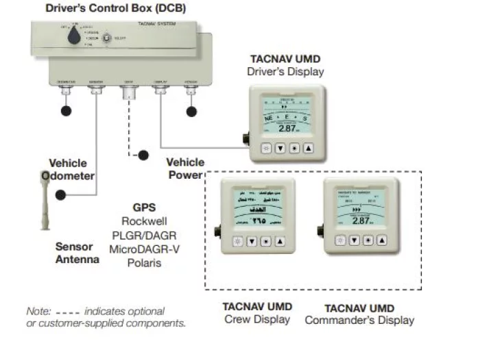
TACNAV® Light
EMCORE’s TACNAV Light is a field-proven digital compass-based battlefield navigation system. Type-classified by U.S. SOCOM and designed specifically for non-turreted vehicles, TACNAV Light offers:
Highlights
GPS backup and enhancement, vehicle position, hull azimuth, and steer-to/cross-track error displays
One of the lowest cost tactical navigation systems available
Improved operational effectiveness and increased force OPTEMPO
Application
Features
Compass for the highest degree of accuracy and unjammable position and navigation information
Dead reckoning and odometer interface for accuracy to within 2-3% of distance traveled
Digital interface with Battle Management Systems for improved situational awareness
Uses TACNAV Universal Multilingual Display (UMD) capable of presenting data in virtually any language
Applications
Light military vehicles
The TACNAV Light is controlled by the Arms Export Control Act (Title 22, USC Sec 2751 et seq.) and the International Traffic in Arms Regulations, ITAR, 22 CFR 120-130, and may not be exported from the United States or disclosed to a foreign person in the United States except as authorized by those regulations.

View page in English


디렉터리 기능
전시회 도우미
In-depth Exhibitor Profiles
Each exhibitor can add as many products and services as they wish, with in-depth information and specifications. This allows buyers to find what they want easily.
Self Provisioning for Exhibitors
Each exhibitor has full control of their content - to edit their company profile, upload products and enter staff details.
방문 계획 수립
북마크 도구와 이벤트 플래너를 사용해 방문하고자 하는 기업과 관심 있는 제품을 검색하세요. 저장한 모든 항목을 조회할 수 있습니다
고급 검색
고급 검색 기능을 사용하여 상품, 인물, 기업의 위치를 빠르게 조회할 수 있습니다. 최첨단 기술을 통해 모든 참가사의 정보를 철저히 스캔하여 세밀하고 관련성 있는 정보를 제공합니다
상호작용 가능 평면도
디렉터리를 사용해 전시회를 손쉽게 둘러보세요. 방문하고자 하는 기업의 위치와, 행사장 내 식당, 화장실, 출입구를 평면도에서 찾을 수 있습니다.
플랫폼 내 메시지
플랫폼 상의 전시 참가사와 관람객에게 직접 연락하여 미팅을 신청하거나 추가 정보를 요청하세요.
최신 콘텐츠
기업, 상품, 뉴스, 이벤트

GE Aerospace
Military Services
From parts supply to total logistics support, GE has the right program to support your maintenance needs -- and keep more of your assets in their theater of operation. Our extensive maintenance management experience can maximize your engine and parts availability by improving procurement lead time and boosting shop productivity.
_700.webp)
Arion Communication Co., Ltd.
TYTO 2
Using the dedicated TYTO2 messenger app, you can pair it with your smartphone and conveniently
send and receive messages in standard format or with AES256 encryption,
With a built-in battery and both satellite and GPS antennas, the device is ruggedized for use in extreme environments. SOS button is designed for immediate emergency/alert notifications.
_700.webp)
LUMIR
Ka-band Transmitter and Phased Array Antenna, KAPA
This Ka-band antenna and data transmission device incorporates electronic beam steering antenna technology and software-defined radio technology as part of the Ka-band downlink system for satellites. It serves as a key component of data downlink systems within the satellite payload, supporting high-speed data transmission. The device enables system optimization through miniaturization, lightweight design, and single-unit modularization.
EMCORE
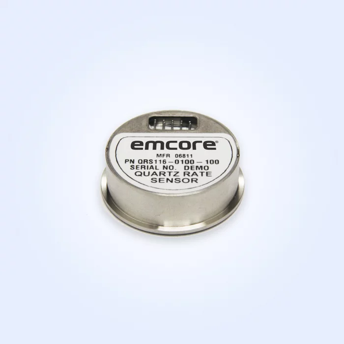
QRS116 Single-Axis Tactical Grade Analog Gyroscope (Non-ITAR)
The QRS116 is a compact angular rate sensor ideally suited for applications in tactical, aerospace and mission-critical instrumentation.
The QRS116 features exceptionally low noise, fast start-up, and a simple electrical interface, the QRS116 has no moving parts ensuring long service life and high MTBF.
System Performance
PARAMETERS SPECIFICATIONS
Standard Ranges ±100°/sec
Input Voltage + 5 Vdc ±5% regulation
Short Term Bias Stability (100 sec at const. temp) 3 deg/hr
Output Noise ( DC to 100 Hz) ≤ 0.002°/√Hz*
* Values Indicated are for ±100°/sec. Range
Features
Exceptional Bias Stability
Unprecedented Low Angle Random Walk Values
Superior Vibration Performance
Compact Industry-Standard Package (Same as QRS11)
Rugged, Compact Package Integrates easily
Applications
Tank Turret Stabilization
Defense Fixed Wing
Defense Helicopter
Unmanned Aerial Vehicles
UGV – Unmanned Ground Vehicle
Platform Stabilization
Camera Stabilization
Antenna Stabilization
ROV – Remotely Operated Vehicle