한국어로 페이지 보기
Seoul ADEX 2025 Digital Directory
Plan your trip to Seoul ADEX 2025 using our state of the art Digital Directory
Register in seconds with just your email


Directory Features
To help you at the show
In-depth Exhibitor Profiles
Each exhibitor can add as many products and services as they wish, with in-depth information and specifications. This allows buyers to find what they want easily.
Self Provisioning for Exhibitors
Each exhibitor has full control of their content - to edit their company profile, upload products and enter staff details.
Plan your trip
Use the bookmarking and event planning tool to research the companies you would like to visit and the products you are interested in finding. You will be able to locate all of your saved companies on our floorplan
Advanced Search
Utilize our advanced search function to quickly locate products, people, and companies. Our state-of-the-art technology thoroughly scans all exhibitor information, delivering precise and relevant results
Interactive Floorplan
Navigate the show effortlessly with our directory. Use the floorplan to locate companies you want to visit and to find your way to onsite restaurants, toilets and site entrances and exits.
On-platform Messaging
Reach out to exhibitors and visitors directly on our platform to set up meetings, or request more information.
Some of our latest content
Companies, Products, News, Events
Aeroforce Logistics, LLC
Consulting Services
Services Include:
-Expert sourcing and pricing
-Cost modeling: Cost per Flight Hour, FFP, EEQ
-Import/Export classification: ECCN, ITAR, Schedule B
-Logistics and supply chain analysis
-Technical review of parts lists and breakdowns
-Source development and sustainment
-Expert sourcing and pricing
-Cost modeling: Cost per Flight Hour, FFP, EEQ
-Import/Export classification: ECCN, ITAR, Schedule B
-Logistics and supply chain analysis
-Technical review of parts lists and breakdowns
-Source development and sustainment
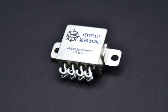
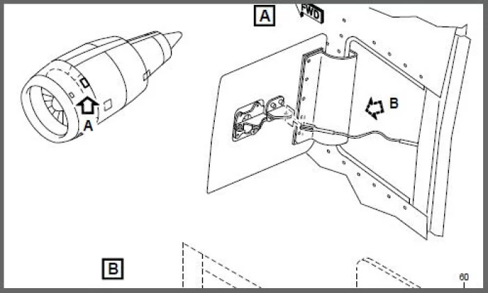
ARS ELECTRONICS S.r.l.
RELAYS
ELECTROMECHANICAL RELAYS
_700.webp)
RFcore
Amplifiers
Available in operating frequencies from HF to Ku-band and with standard output powers ranging from 2 to 1000 watts. Standards Functions Include:
FWD/RVS Detector, Mute, Temperature Monitoring, VSWR Alarm with Protection, Over Temperature Alarm with Protection and Auto-recovery, Over voltage protection, ALC, AGC and Current Monitoring.
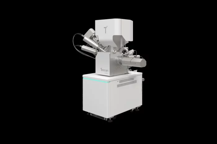
Tescan Group a.s.
TESCAN Plasma FIB-SEM, AMBER X2
An optimized Plasma FIB-SEM platform with proprietary gas chemistries for high-quality delayering of the most current semiconductor devices

View page in English


디렉터리 기능
전시회 도우미
In-depth Exhibitor Profiles
Each exhibitor can add as many products and services as they wish, with in-depth information and specifications. This allows buyers to find what they want easily.
Self Provisioning for Exhibitors
Each exhibitor has full control of their content - to edit their company profile, upload products and enter staff details.
방문 계획 수립
북마크 도구와 이벤트 플래너를 사용해 방문하고자 하는 기업과 관심 있는 제품을 검색하세요. 저장한 모든 항목을 조회할 수 있습니다
고급 검색
고급 검색 기능을 사용하여 상품, 인물, 기업의 위치를 빠르게 조회할 수 있습니다. 최첨단 기술을 통해 모든 참가사의 정보를 철저히 스캔하여 세밀하고 관련성 있는 정보를 제공합니다
상호작용 가능 평면도
디렉터리를 사용해 전시회를 손쉽게 둘러보세요. 방문하고자 하는 기업의 위치와, 행사장 내 식당, 화장실, 출입구를 평면도에서 찾을 수 있습니다.
플랫폼 내 메시지
플랫폼 상의 전시 참가사와 관람객에게 직접 연락하여 미팅을 신청하거나 추가 정보를 요청하세요.
최신 콘텐츠
기업, 상품, 뉴스, 이벤트
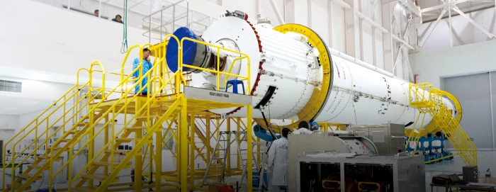
Korea Aerospace Industries
Korea Space Launch Vehicle
KAI participates in the system integration of the KSLV-II and development of
its first-stage propellant tank while trying to secure the technology of Space Launch Vehicle.

ABC Essais
Aerospace - ABC Essais
The vast range of ABC products allows us to meet the greatt majority of customer requests. Many products exist in our catalog and can be declined either through AMM or CMM, or through aircraft, or through more universal functions. Thus we propose test means associated with capabilities (universal benches) or associated with particular components (CMM) ...
Illumia Labs Inc
Illumia XAVA
Illumia XAVA is an authoring and planning tool that enables trainers to create customized training content, including interactive learning materials, lecture materials with knowledge checks and AI-driven Q&A support.
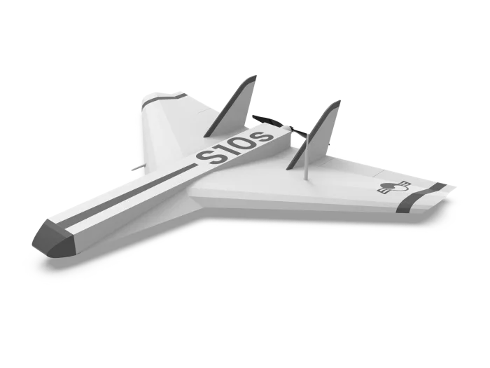
PABLO AIR
PabloM S10s
The S10s, the first model of the PabloM series, is a loitering munition designed for strike missions. Leveraging mesh communication and AI-enabled swarm flight, it can execute both simultaneous and sequential self-destructive strikes against targets, effectively neutralizing diverse “anti-drone” systems. The S10s launches autonomously from a dedicated platform and can sustain flight for over 30 minutes, enabling wide-area operational coverage. When engaging a target, it performs a steep dive of up to 45 degrees at speeds reaching 150 km/h, ensuring rapid and precise impact. Built from lightweight foam-board materials, the S10s is optimized for fast, large-scale production during operations. Furthermore, its modular open-architecture design, aligned with the K-MOSA concept, allows mission payloads to be quickly swapped and integrated, delivering exceptional flexibility and interoperability in real combat environments.