한국어로 페이지 보기
Seoul ADEX 2025 Digital Directory
Plan your trip to Seoul ADEX 2025 using our state of the art Digital Directory
Register in seconds with just your email


Directory Features
To help you at the show
In-depth Exhibitor Profiles
Each exhibitor can add as many products and services as they wish, with in-depth information and specifications. This allows buyers to find what they want easily.
Self Provisioning for Exhibitors
Each exhibitor has full control of their content - to edit their company profile, upload products and enter staff details.
Plan your trip
Use the bookmarking and event planning tool to research the companies you would like to visit and the products you are interested in finding. You will be able to locate all of your saved companies on our floorplan
Advanced Search
Utilize our advanced search function to quickly locate products, people, and companies. Our state-of-the-art technology thoroughly scans all exhibitor information, delivering precise and relevant results
Interactive Floorplan
Navigate the show effortlessly with our directory. Use the floorplan to locate companies you want to visit and to find your way to onsite restaurants, toilets and site entrances and exits.
On-platform Messaging
Reach out to exhibitors and visitors directly on our platform to set up meetings, or request more information.
Some of our latest content
Companies, Products, News, Events
_700.webp)
Parkor Korea Indus
Integrated Weather Observation System
The Integrated Weather Observation System (IWOS®) is the compact, wireless, rugged weather station that can be customized to any customers’ specific needs. This system can replace legacy weather stations that require hardline power or extensive infrastructure for permanent installation. It integrates up to eight environmental sensing modules with optional satellite communication in a package that fits into a single case and weighs less than 25 lb. In addition to its portability, performance, and professional-grade construction, the modular design of the IWOS lends itself to higher accuracy, higher availability, and a lower lifecycle cost thanks to its easily replaceable and serviceable modules.
EO System
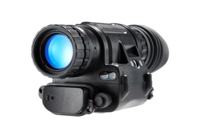
Industrial Security
Industrial and police-use civilian night vision solution products
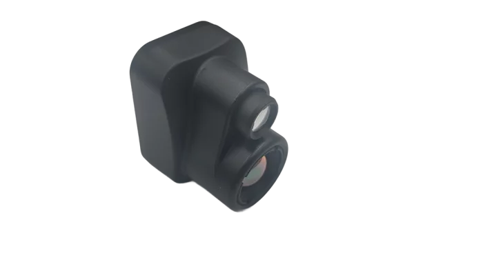
CanLab
EO/IR Camera (FPV Type)
A cost-effective and reliable EO/IR solution designed for unmanned platforms, combining compact design with strong performance. The system integrates QVGA/VGA-class infrared sensors and 2–20 megapixel EO cameras, providing versatile options to meet different operational requirements.
o Infrared (IR) Sensor: QVGA/VGA resolution, optimized for detection and recognition in short-to-mid range surveillance
o Electro-Optical (EO) Module: 2MP–20MP visible light cameras with high-resolution imaging, adaptable to multiple mission profiles
o Design Philosophy: Lightweight, compact, and robust for integration into unmanned aerial vehicles (UAVs), unmanned surface vehicles (USVs), and ground robotics
o Key Value: Balances price competitiveness, system reliability, and modular scalability for mass deployment
ZYX Technology
DIVE
DIVE (Digital Interactive Virtual Environment) is a GIS-based smart construction management platform jointly developed by ZYX Technology and Korea Expressway Corporation. Designed to meet the growing demand for intelligent infrastructure solutions, DIVE provides real-time integration, monitoring, and analysis of all location-based construction data.
By consolidating diverse sources such as design drawings, land maps, aerial imagery, BIM data, drone footage, and CCTV into a single platform, DIVE enables comprehensive, on-site visibility and control. From large-scale infrastructure to complex tunnel projects, all key information can be accessed and compared in real time, allowing for smarter, faster, and more accurate decision-making.
The main dashboard provides a live overview of each project site, including tasks, equipment, workers, events, and safety issues. With its daily work management feature, site managers can view exact personnel and equipment allocations for each zone, improving efficiency and minimizing risk.
DIVE also supports seamless integration with tunnel monitoring systems, offering real-time access to excavation status, geotechnical sensors, and worker presence inside the tunnel. This ensures enhanced safety and process transparency in high-risk environments.
Drone integration further strengthens site management by providing up-to-date aerial visuals, reducing blind spots and enabling rapid response to field changes. In addition, the platform links design drawings with cadastral maps to streamline permitting, track construction progress, and manage change orders with geographic accuracy.
Whether you're building roads, tunnels, or complex infrastructure, DIVE empowers construction teams with a powerful digital environment to manage the entire project lifecycle.

View page in English


디렉터리 기능
전시회 도우미
In-depth Exhibitor Profiles
Each exhibitor can add as many products and services as they wish, with in-depth information and specifications. This allows buyers to find what they want easily.
Self Provisioning for Exhibitors
Each exhibitor has full control of their content - to edit their company profile, upload products and enter staff details.
방문 계획 수립
북마크 도구와 이벤트 플래너를 사용해 방문하고자 하는 기업과 관심 있는 제품을 검색하세요. 저장한 모든 항목을 조회할 수 있습니다
고급 검색
고급 검색 기능을 사용하여 상품, 인물, 기업의 위치를 빠르게 조회할 수 있습니다. 최첨단 기술을 통해 모든 참가사의 정보를 철저히 스캔하여 세밀하고 관련성 있는 정보를 제공합니다
상호작용 가능 평면도
디렉터리를 사용해 전시회를 손쉽게 둘러보세요. 방문하고자 하는 기업의 위치와, 행사장 내 식당, 화장실, 출입구를 평면도에서 찾을 수 있습니다.
플랫폼 내 메시지
플랫폼 상의 전시 참가사와 관람객에게 직접 연락하여 미팅을 신청하거나 추가 정보를 요청하세요.
최신 콘텐츠
기업, 상품, 뉴스, 이벤트
Jaewon Korea
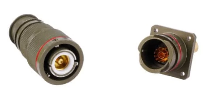
VG96929
JWGE connector which was derived from the VG95234, was developed for low-voltage/high-current transmission and, when combined, exhibits IP68 water and dust resistance, also exhibiting excellent durability and mechanical performance in a temperature range of 55° to +125°C. These features are applied and utilized in military vehicles and various industrial equipment.
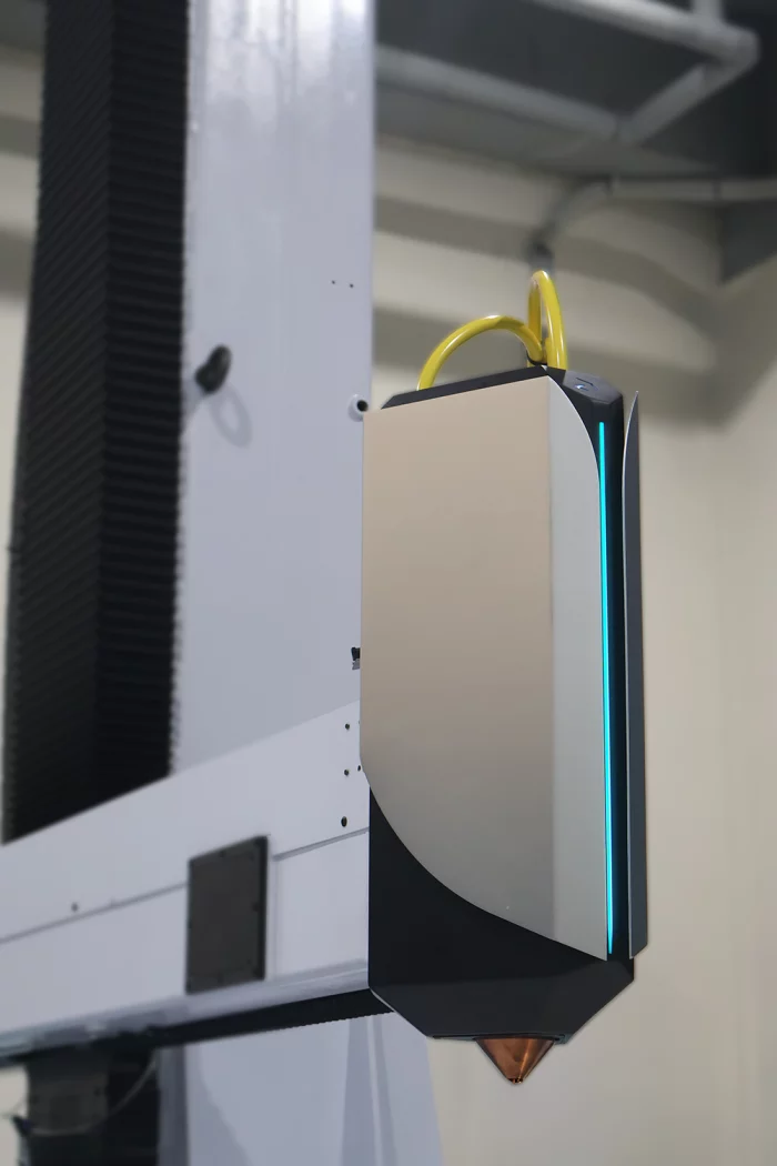
LabAM24
LW-DED 3D Printing Head Module "InertOn"
LW-DED 3D printing head module for Morphing Shield Technology. Morphing Shield Technology builds aportable inert gas enviroment surrounding the melting zone for laser wire DED Process.
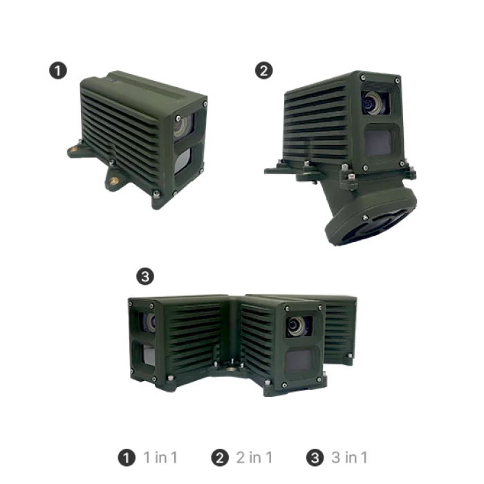
Young Poong Electronics
MULTI SENSOR IMAGE FUSION SYSTEM
1. Integrate the most effective aspects of Visible and IR(Infrared) image.
2. Increase the efficiency through the ability to use in all weather conditions, day or night, including fog.
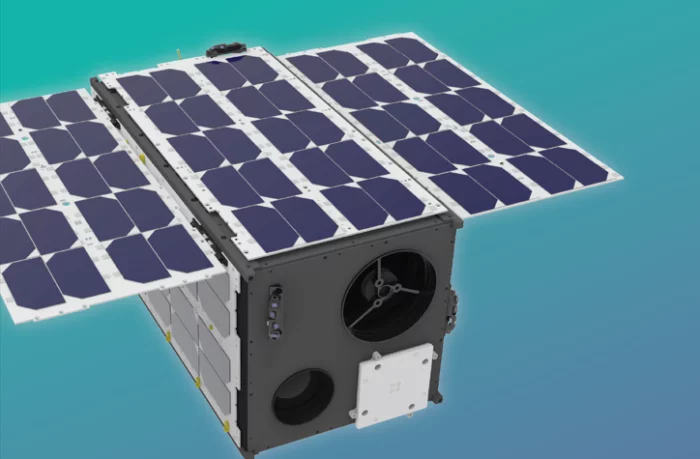
Nara Space Technology Inc.
NarSha
NarSha is a dedicated small satellite for monitoring methane (CH₄) emissions, a key contributor to the climate crisis. It is the first satellite of its kind in South Korea to be developed and led by a private company. The launch of NarSha-1 is targeted for the fourth quarter of 2026.