한국어로 페이지 보기
Seoul ADEX 2025 Digital Directory
Plan your trip to Seoul ADEX 2025 using our state of the art Digital Directory
Register in seconds with just your email


Directory Features
To help you at the show
In-depth Exhibitor Profiles
Each exhibitor can add as many products and services as they wish, with in-depth information and specifications. This allows buyers to find what they want easily.
Self Provisioning for Exhibitors
Each exhibitor has full control of their content - to edit their company profile, upload products and enter staff details.
Plan your trip
Use the bookmarking and event planning tool to research the companies you would like to visit and the products you are interested in finding. You will be able to locate all of your saved companies on our floorplan
Advanced Search
Utilize our advanced search function to quickly locate products, people, and companies. Our state-of-the-art technology thoroughly scans all exhibitor information, delivering precise and relevant results
Interactive Floorplan
Navigate the show effortlessly with our directory. Use the floorplan to locate companies you want to visit and to find your way to onsite restaurants, toilets and site entrances and exits.
On-platform Messaging
Reach out to exhibitors and visitors directly on our platform to set up meetings, or request more information.
Some of our latest content
Companies, Products, News, Events
LMS
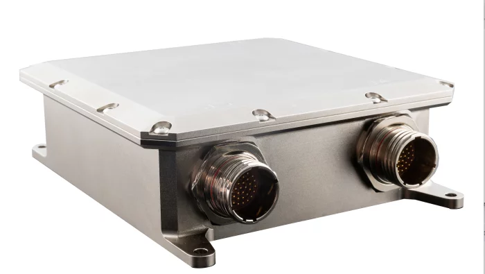
Signal Conditioner Unit (SCU)
Each SCU can interface with up to eight (8) fuel probes with temperature detection and/or fuel probes with compensators. It will process capacitive and resistive readings to determine the fuel heights for each probe and transmit the calculated fuel volume to the cockpit.
_700.webp)
Prolangs Inc.
Professional Defense Interpretation
Our team of interpreters, all specialists in the defense sector, brings extensive hands-on experience and relevant training. We help ensure the success of international business endeavors by acting as trusted partners to our clients.
• 24/7 defense interpretation services
• Fully equipped to deliver simultaneous, consecutive, escort, and whispering interpretation services for a variety of conferences, seminars, and official events
• Exclusive interpretation service provider for the first-ever K-Defense Day Event
◎Simultaneous interpretation
Interpretation conducted in almost real time using interpretation equipment (FM interpretation equipment, and receivers) in an interpreter booth where a pair of interpreters do the interpretation. The audience hears the interpreter's voice through the receivers. It is often used in conferences, forums, symposiums and memorials attended by a large number of people.
◎Consecutive interpretation
Unlike simultaneous interpretation, this is conducted served after a speaker's words end. It is mainly used for meetings with limited attendance, such as ministerial talks and summits.
◎Accompanying interpretation
This is similar to consecutive interpretation, but the interpreter moves with the speaker and interprets. It is mainly used for sightseeing and field trips where interpreters are needed.
◎Whispering interpretation
Interpretation for a small audience, listening to what a speaker says and then interpreting it for an audience in a quiet voice. If needed, the interpreter can use whispering equipment (transmitters and receivers).
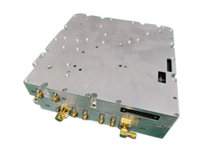
Eltronix Co., Inc
100W High Power AMP Module
The 100W High Power Amplifier is an L-band amplifier that delivers 100W output across two channels with a 60% duty cycle.
It offers a gain of over 50 dB, with output flatness of 2 dB depending on the input signal level.
The amplifier provides an ACLR performance of -20 dBc at maximum output.
Equipped with an output-stage bandpass filter (BPF), it achieves excellent harmonic suppression of -70 dBc.
Built-in monitoring functions include output signal and temperature monitoring.

Marvin Test Solutions
F-15 Test and Support Equipment

View page in English


디렉터리 기능
전시회 도우미
In-depth Exhibitor Profiles
Each exhibitor can add as many products and services as they wish, with in-depth information and specifications. This allows buyers to find what they want easily.
Self Provisioning for Exhibitors
Each exhibitor has full control of their content - to edit their company profile, upload products and enter staff details.
방문 계획 수립
북마크 도구와 이벤트 플래너를 사용해 방문하고자 하는 기업과 관심 있는 제품을 검색하세요. 저장한 모든 항목을 조회할 수 있습니다
고급 검색
고급 검색 기능을 사용하여 상품, 인물, 기업의 위치를 빠르게 조회할 수 있습니다. 최첨단 기술을 통해 모든 참가사의 정보를 철저히 스캔하여 세밀하고 관련성 있는 정보를 제공합니다
상호작용 가능 평면도
디렉터리를 사용해 전시회를 손쉽게 둘러보세요. 방문하고자 하는 기업의 위치와, 행사장 내 식당, 화장실, 출입구를 평면도에서 찾을 수 있습니다.
플랫폼 내 메시지
플랫폼 상의 전시 참가사와 관람객에게 직접 연락하여 미팅을 신청하거나 추가 정보를 요청하세요.
최신 콘텐츠
기업, 상품, 뉴스, 이벤트
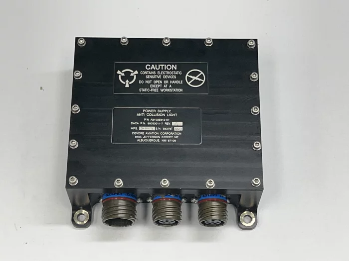
DIGITRON. Co., Ltd.
LIGHT POWER SUPPLY
- Interior/Exterior lighting control device
- Input Power : 28 VDC
- MIL-STD-461
- MIL-STD-704
- RTCA/DO-160 Section 25

Hanwha Aerospace
Green Energy
Hanwha is ramping up its response to the challenges of climate change as green energy becomes a global necessity. As a comprehensive green energy solutions provider, we are pioneering future markets by combining our energy production and transportation know-how with our expertise in energy sources and materials. Hanwha is at the forefront of building a green energy value chain that encompasses solar, hydrogen, and wind energy as well as green marine solutions. Our solar power business is expanding from module production to a fully integrated supply chain, in addition to offering high-value-added services using information technology. We are accelerating our development of onshore and offshore wind power generation and creating sustainable transformation in the ocean and marine energy ecosystem. From land-based energy solutions to low- and zero-carbon marine technologies, we are tapping into green energy’s outstanding potential and strengthening our competitiveness as a green energy solutions provider to lead the way to net zero.
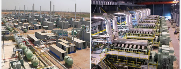
STX Engine
Stationary Power Generation Engine
STX Engine produces medium speed engine driven power generation equipment that can satisfy customers 100% by ideally combining medium speed engines, which have been collectively produced at our Changwon factory since obtaining licenses from the mid 1970's from MAN ENERGY SOLUTIONS in Germany and NIIGATA POWER SYSTEM in Japan, with a power generation system designed with rich experience in the area of system engineering.
By installing diesel engine power generation equipment in locations across Korea and overseas, such as on islands, remote areas, resorts, etc., where no public power supply is available, as well as industrial complexes and hospitals which require good source of power, and factories receiving expensive public power supply, etc., our customers can confirm the investment effect within a short period of time after experiencing the power supply we make available to them, as well as low installation and operation costs and maximized availability of the equipment.
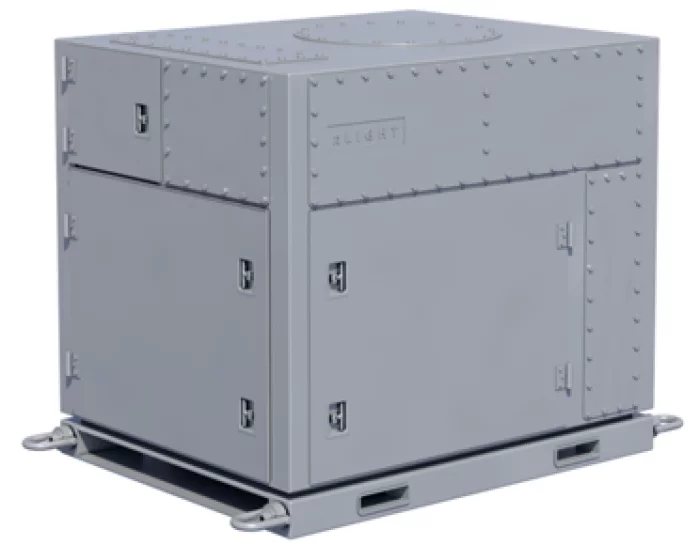
nLIGHT Inc
C-UAS and Advanced Threats 70kW CBC HEL Source
C-UAS and Advanced Threats 70kW CBC HEL Source