한국어로 페이지 보기
Seoul ADEX 2025 Digital Directory
Plan your trip to Seoul ADEX 2025 using our state of the art Digital Directory
Register in seconds with just your email


Directory Features
To help you at the show
In-depth Exhibitor Profiles
Each exhibitor can add as many products and services as they wish, with in-depth information and specifications. This allows buyers to find what they want easily.
Self Provisioning for Exhibitors
Each exhibitor has full control of their content - to edit their company profile, upload products and enter staff details.
Plan your trip
Use the bookmarking and event planning tool to research the companies you would like to visit and the products you are interested in finding. You will be able to locate all of your saved companies on our floorplan
Advanced Search
Utilize our advanced search function to quickly locate products, people, and companies. Our state-of-the-art technology thoroughly scans all exhibitor information, delivering precise and relevant results
Interactive Floorplan
Navigate the show effortlessly with our directory. Use the floorplan to locate companies you want to visit and to find your way to onsite restaurants, toilets and site entrances and exits.
On-platform Messaging
Reach out to exhibitors and visitors directly on our platform to set up meetings, or request more information.
Some of our latest content
Companies, Products, News, Events
Augmented Knowledge Corp.
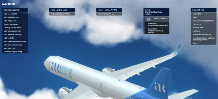
Airbus A321neo Training & Education Simulator
Our XR-based aircraft maintenance simulator is officially certified by the Ministry of Land, Infrastructure and Transport (MOLIT) of South Korea for training and education.
It provides specialized training environments for the A321, B737-MAX, and B737-800NG aircraft, featuring over 80 detailed modules—including procedures for engine removal, main landing gear installation, and more.
This subscription-based simulator is fully compatible with smartphones, tablets, and wearable XR devices, enabling seamless access through a cloud-based web service. Users can train anytime, anywhere—perfect for both remote learning and remote maintenance scenarios.
Compared to traditional classroom learning, the XR platform is 4 times more effective and requires only one-third the training time. It also improves user confidence in real-world technical applications by up to 275%.
By transforming traditional paper manuals into immersive, interactive training environments, the simulator delivers the next generation of aircraft MRO education for both civil and defense sectors.

Kia
New 2½ Ton Medium Cargo Truck
Kia newly developed 2½ ton Medium Cargo Truck to fit all- battlefield environments with the best driving performance and durability and survivability based on its long-accumulated military and commercial vehicles technology.
280 – HP Diesel Engine
Mounting commercial high-efficiency and high-hoursepower engines onto behicles for tracking capability, cold starting, and electromagnetic wave shielding adequate for military applications
Automatic transmission
Improves the convenience of operating the vehicle, and prevents the engine from shutting down and the vehicle from slipping when it is started on a slope.
All wheel drive (AWD)
The all wheel drive function is applied for improving tracking and hauling power, steering capability and stability, and off-road driving power.
Full air braking system and ABS
Applying a full-air braking system to the vehicle for reducing the force required for pressing the pedal, and ensuring precise braging force.
Applying ABS for keeping the braking force and steering capability intact and securing vehiclestability on anuneven surface.
Air pressure control device of tire (optional)
Evacuates from poor subsoil by controlling air pressure of tire inside the cabin
Cabin
This cab-over cabin provides improved legibility compared with bonnet-type. Applying specifications of commercial vehicles enhances convenience of driving vehicle
Air conditioner
Provides a pleasant environment to riders all the time and secures visibility of a driver by defrosting the windshield.
Instruments and switches
Commercial vehicle instruments for improved legibility, and switches ergonomically arranged for enhanced operability
Augmented Knowledge Corp.
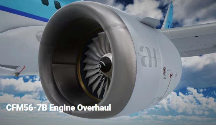
CFM56-7B Engine Overhaul Training Simulator
Our XR-based aircraft maintenance simulator is officially certified by the Ministry of Land, Infrastructure and Transport (MOLIT) of South Korea for training and education.
It provides specialized training environments for the A321, B737-MAX, and B737-800NG aircraft, featuring over 80 detailed modules—including procedures for engine removal, main landing gear installation, and more.
This subscription-based simulator is fully compatible with smartphones, tablets, and wearable XR devices, enabling seamless access through a cloud-based web service. Users can train anytime, anywhere—perfect for both remote learning and remote maintenance scenarios.
Compared to traditional classroom learning, the XR platform is 4 times more effective and requires only one-third the training time. It also improves user confidence in real-world technical applications by up to 275%.
By transforming traditional paper manuals into immersive, interactive training environments, the simulator delivers the next generation of aircraft MRO education for both civil and defense sectors.

Click Bond, Inc.
CB2009 - Two-Lug Bracket-Retained Nutplate
Two-lug nutplate with bracket-retained nut element for FOD-critical applications where nut replaceability is desired but nut element retainer clips are not permitted. Supplied with integral elastic installation fixture. Fixture simplifies nutplate installation by providing bondline clamp-up and maintenance of concentricity with the fastener hole, ensuring full availability of nut float and protection of threads from adhesive.

View page in English


디렉터리 기능
전시회 도우미
In-depth Exhibitor Profiles
Each exhibitor can add as many products and services as they wish, with in-depth information and specifications. This allows buyers to find what they want easily.
Self Provisioning for Exhibitors
Each exhibitor has full control of their content - to edit their company profile, upload products and enter staff details.
방문 계획 수립
북마크 도구와 이벤트 플래너를 사용해 방문하고자 하는 기업과 관심 있는 제품을 검색하세요. 저장한 모든 항목을 조회할 수 있습니다
고급 검색
고급 검색 기능을 사용하여 상품, 인물, 기업의 위치를 빠르게 조회할 수 있습니다. 최첨단 기술을 통해 모든 참가사의 정보를 철저히 스캔하여 세밀하고 관련성 있는 정보를 제공합니다
상호작용 가능 평면도
디렉터리를 사용해 전시회를 손쉽게 둘러보세요. 방문하고자 하는 기업의 위치와, 행사장 내 식당, 화장실, 출입구를 평면도에서 찾을 수 있습니다.
플랫폼 내 메시지
플랫폼 상의 전시 참가사와 관람객에게 직접 연락하여 미팅을 신청하거나 추가 정보를 요청하세요.
최신 콘텐츠
기업, 상품, 뉴스, 이벤트

Hydraulics International Inc.
Commercial Aircraft Ground Support Equipment
A world well know Aviation Ground Support Equipment (AGSE) in support of military and commercial aircraft
GEOSTORY Co., Ltd
Bathymetric LiDAR System
Our LiDAR uses a custom-designed laser that separates 1064 nm and 532 nm wavelengths from a single source, with two dedicated receivers capturing each set of data independently.
Inside the system, the linear laser beam is refracted at a 10-degree angle through a prism to enable circular scanning. An RF module is also integrated for real-time equipment status monitoring.
From circuit board design to component selection, every part of this system was developed in-house by multiple institutions.
As a result, we have successfully eliminated reliance on foreign technology.

Armada / Asian Military Review
Asian Military Review (AMR)
Since 1993, AMR has become the leading and most recognised journal on defence analysis, affairs and news in the Asia-Pacific region. It is unbiased, objective and authoritative. The editorial content includes capability analysis, special reports and relevant news coverage from the region. It has become the top resource for those working in the Asian military and defence organisations.
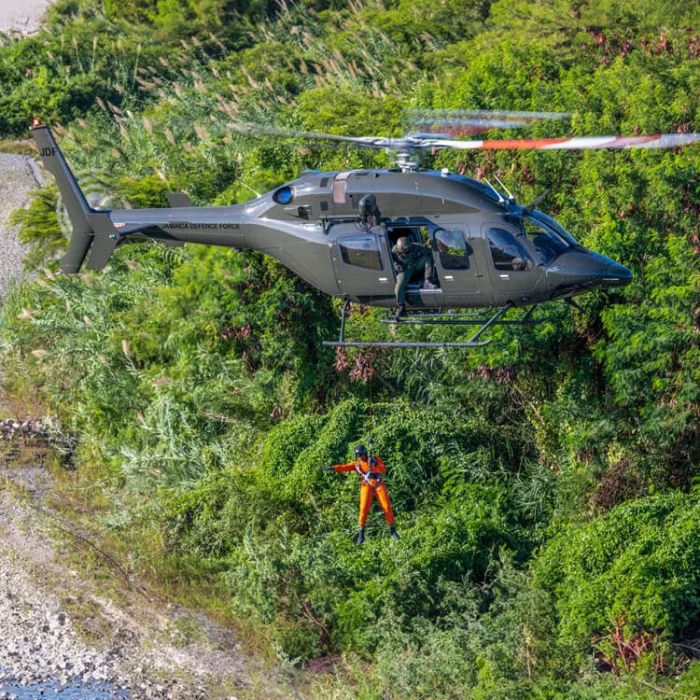
BELL Textron Inc.
Bell 429
Bell 429 - Arrive on the scene quickly, and be ready for anything. Ample cabin space, large doors and adjustable components accommodate your equipment --- and keep your crew comfortable.