한국어로 페이지 보기
Seoul ADEX 2025 Digital Directory
Plan your trip to Seoul ADEX 2025 using our state of the art Digital Directory
Register in seconds with just your email


Directory Features
To help you at the show
In-depth Exhibitor Profiles
Each exhibitor can add as many products and services as they wish, with in-depth information and specifications. This allows buyers to find what they want easily.
Self Provisioning for Exhibitors
Each exhibitor has full control of their content - to edit their company profile, upload products and enter staff details.
Plan your trip
Use the bookmarking and event planning tool to research the companies you would like to visit and the products you are interested in finding. You will be able to locate all of your saved companies on our floorplan
Advanced Search
Utilize our advanced search function to quickly locate products, people, and companies. Our state-of-the-art technology thoroughly scans all exhibitor information, delivering precise and relevant results
Interactive Floorplan
Navigate the show effortlessly with our directory. Use the floorplan to locate companies you want to visit and to find your way to onsite restaurants, toilets and site entrances and exits.
On-platform Messaging
Reach out to exhibitors and visitors directly on our platform to set up meetings, or request more information.
Some of our latest content
Companies, Products, News, Events
 VPX3-C11 SBC_290909_700.webp)
COTS Technology
(COTS) VPX3-C11 SBC
The VPX3-C11 which provides a full 3U OpenVPX(VITA 65) is a Single Board Computer(SBC) that combines the power, versatility, cost-effectiveness of the 11th generation Intel Xeon W processor and RM590E PCH chipset with the reliability. VPX3-C11 is based on the Intel Xeon W-
11865MLE CPU that has 8 cores running at max 4.5GHz and providing 32Gbytes of
high-bandwidth DDR4 SDRAM. Intel Xeon processor includes an integrated
Intel UHD Graphics 11th Gen(32 EU) graphics engine, providing discrete GPU
performance with OpenGL for graphicsintensive applications.
For storage application VPX3-C11 provides the built-in 80GB SLC NVMe SSD solution
via PCIe x4 lanes as well as the external SATA expansion through VPX site.
The VPX3-C11 satisfies the demanding applications ranging from tactical aircraft
to armoured vehicles to rugged industrial systems, with its rich complement of
features and I/O including Intel Graphics, Integrated Platform Management
Interface, Gigabit Ethernet, DIO, Serial channels, USB ports and more. Especially
VPX3-C11 was designed to keep the pin compatibility with VPX3-C11, previous 6th
Generation model in terms of I/O interface signal arrangement.
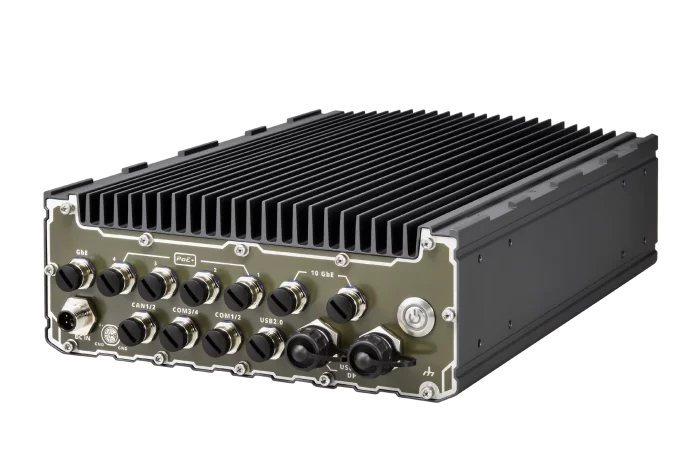
NeXber Co., Ltd.
SEMIL-2000GC
SEMIL-2000GC is an extreme-rugged IP69K dustproof and waterproof edge AI platform in a 2U 19" rack-mount form factor. SEMIL- 2000GC incorporates Neousys' best-in-class thermal design to ensure fanless maximum GPU performance in wide range -40°C to 70°C temperatures. The system is also integrated with an NVIDIA® L4 GPU that offers up to 2.5 times the performance over Tesla T4.
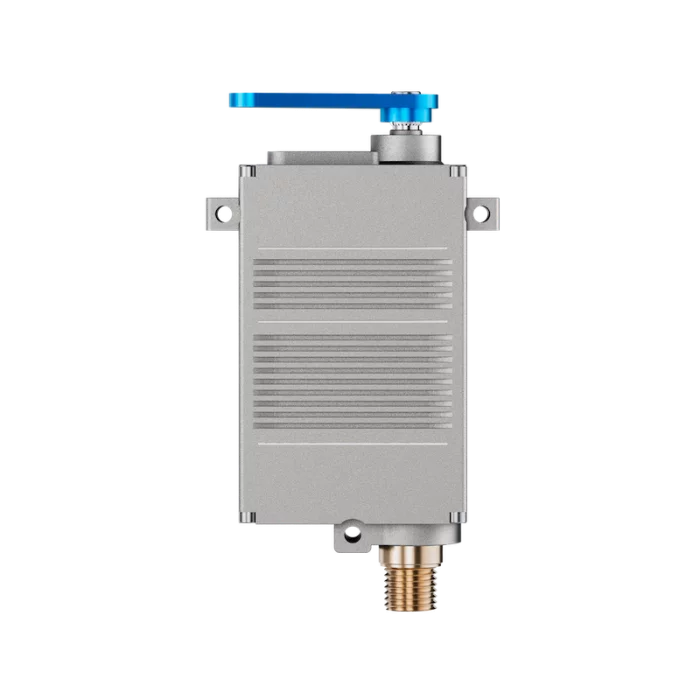
Volz Servos
DA 22-BLDC
DA 22-BLDC Brushless Actuator
To guarantee maximum safety and reliability, its brushless motor and contactless, wear-free position sensing system makes the DA 22 BLDC immune to wear, vibrations and shock loads. It has especially been designed for usage in harsh environments and for safety-critical applications that require an actuator with high endurance.
The conductive aluminum case and the shielded connection cable are reducing the susceptibility to any kind to EMI/RFI noise to the absolute minimum.
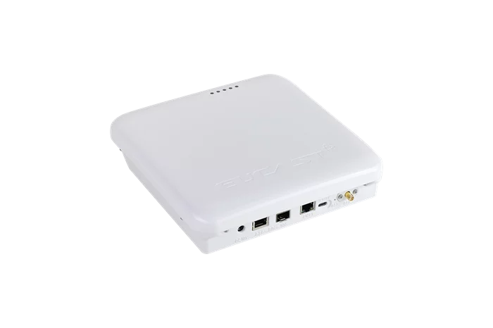
EUCAST
ENS2000 - Sub 6Ghz 5G small cell (gNodeB)
The ENS2000 (Sub-6GHz 5G small cell) is a small cell capable of providing 5G services with a coverage radius of several hundred meters. It supports operator 5G bands such as n78 (3.5GHz) and n79 (4.7GHz) for private 5G. Originally developed for indoor use, but it can also be installed in enclosures such as streetlight cabinets for outdoor deployment when needed.

View page in English


디렉터리 기능
전시회 도우미
In-depth Exhibitor Profiles
Each exhibitor can add as many products and services as they wish, with in-depth information and specifications. This allows buyers to find what they want easily.
Self Provisioning for Exhibitors
Each exhibitor has full control of their content - to edit their company profile, upload products and enter staff details.
방문 계획 수립
북마크 도구와 이벤트 플래너를 사용해 방문하고자 하는 기업과 관심 있는 제품을 검색하세요. 저장한 모든 항목을 조회할 수 있습니다
고급 검색
고급 검색 기능을 사용하여 상품, 인물, 기업의 위치를 빠르게 조회할 수 있습니다. 최첨단 기술을 통해 모든 참가사의 정보를 철저히 스캔하여 세밀하고 관련성 있는 정보를 제공합니다
상호작용 가능 평면도
디렉터리를 사용해 전시회를 손쉽게 둘러보세요. 방문하고자 하는 기업의 위치와, 행사장 내 식당, 화장실, 출입구를 평면도에서 찾을 수 있습니다.
플랫폼 내 메시지
플랫폼 상의 전시 참가사와 관람객에게 직접 연락하여 미팅을 신청하거나 추가 정보를 요청하세요.
최신 콘텐츠
기업, 상품, 뉴스, 이벤트
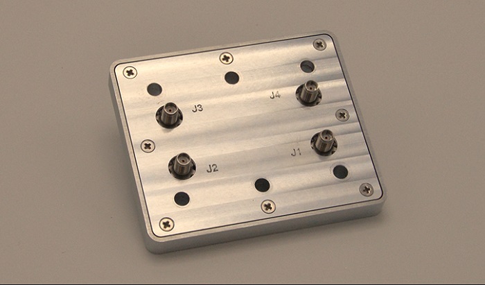
Haigh-Farr, Inc.
Support Hardware
Haigh-Farr designs support hardware to work hand-in-hand with our solutions to maximize performance. Our support hardware utilizes the same well-proven construction as the antennas they support. Power Dividers, Combiners, Hybrids & Diplexers
_700.webp)
DUKSAN AETHERCT Co., Ltd.
Industrial Gas Tube Skids
DS Aether CT provides various industrial Gas Tube Trailers such as Helium (He), Hydrogen (H2), Neon (Ne), Nitrogen (N2) and Argon (Ar), as well as CNG.
The working pressure is set to national requirements or customer's demands such as 166 bar, 200 bar, or 250 bar. The color of the jumbo tubes and skid frames follows ISO color codes, or the designations of customers.
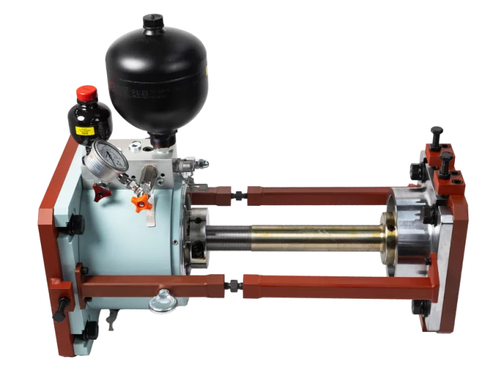
HANMI HYDRAULIC MACHINERY CO., LTD.
Hydraulic Top Bracing
Hydraulic top bracing is an attenuation device installed between the main engine and the hull of the ship to reduce thermal expansion and vibration from the main engine to natural frequencies. The operating principle is an automatic control operating system through in/out and on/off the operating range of the hydraulic top bracing according to the rpm of the main engine.
The number of hydraulic cylinders per engine is typically 2, 4, 6 depending on the type of engine, up to 8 are installed if necessary, and 1~2 of control panels are installed.
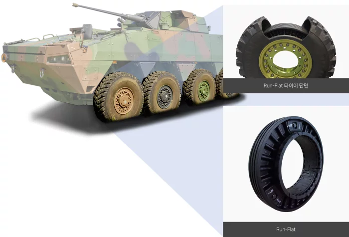
WOORIDS Co.,Ltd.
Runflat business
Next-generation wheeled military vehicles are essential to secure maneuverability and survivability for efficient power operation even in the worst weather and terrain conditions, so we have developed a run-flat product with pure domestic technology that can drive to a safe zone where tires can be repaired and replaced with quality that meets the standards of the United States and NATO (North Atlantic Treaty Organization) while ensuring stable steering and driving performance by applying our unique design in the event of tire pressure loss due to tire damage.
Based on this, we produce and supply run-flat-related products to wheeled military vehicle manufacturers.