한국어로 페이지 보기
Seoul ADEX 2025 Digital Directory
Plan your trip to Seoul ADEX 2025 using our state of the art Digital Directory
Register in seconds with just your email


Directory Features
To help you at the show
In-depth Exhibitor Profiles
Each exhibitor can add as many products and services as they wish, with in-depth information and specifications. This allows buyers to find what they want easily.
Self Provisioning for Exhibitors
Each exhibitor has full control of their content - to edit their company profile, upload products and enter staff details.
Plan your trip
Use the bookmarking and event planning tool to research the companies you would like to visit and the products you are interested in finding. You will be able to locate all of your saved companies on our floorplan
Advanced Search
Utilize our advanced search function to quickly locate products, people, and companies. Our state-of-the-art technology thoroughly scans all exhibitor information, delivering precise and relevant results
Interactive Floorplan
Navigate the show effortlessly with our directory. Use the floorplan to locate companies you want to visit and to find your way to onsite restaurants, toilets and site entrances and exits.
On-platform Messaging
Reach out to exhibitors and visitors directly on our platform to set up meetings, or request more information.
Some of our latest content
Companies, Products, News, Events
 LumirX Satellite Systems_700.webp)
LUMIR
X-band Small SAR Satellite Systems and High Resolution SAR Imagery
Lumir’s small SAR constellation system will comprise 18 satellites capable of capturing ultra-high-resolution images of key areas around the globe within an hour. This rapid data acquisition and delivery will enable real-time access to imagery, making the system especially valuable for time-sensitive applications such as surveillance, disaster response, and emergency management. Through LumirX’s advanced signal and image processing platform, SARDIP™, customers will be able to easily search for, purchase, and utilize SAR imagery. The platform will offer a suite of analysis tools, allowing users to extract meaningful insights and apply them efficiently across various industries.
_700.webp)
TelePIX Co., Ltd.
SatCHAT
An AI-powered geospatial intelligence platform that allows users to interact with satellite imagery through natural language. By integrating LLMs with advanced image processing and object detection, SatCHAT makes EO data accessible to non-experts, enabling real-time infrastructure monitoring, event detection, and automated reporting. This lowers the barrier for industries to leverage satellite insights.
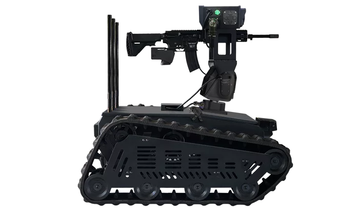
SkyAutoNet
Squad Unmanned Tactical Robot
# Key Features
- Drone Detection and Neutralization
> Detects and jams multicopter and suicide drones, and engages targets with gunfire.
- Enemy Detection and Fire Support
> Identifies personnel and vehicles within range, provides automatic target designation (digital reticle), and coordinates with squad-level weapons.
- 360° Surveillance and Reconnaissance
> Conducts all-round monitoring of bases and forward positions, deploys ahead in hazardous areas, and transmits real-time video.
- Close Support and Resupply
> Carries and delivers ammunition, water, and medical supplies to designated locations.
# Expected Effects
- Reduces soldiers’ combat burden, enhances survivability, and contributes to higher mission success rates.
- Strengthens small-unit self-defense capabilities against drone attacks, which are emerging as a key threat in future battlefields.
Invest Quebec
Spacebridge
30년+ 위성통신 경험을 바탕으로 VSAT 허브/모뎀과 광대역 SATCOM을 제공하며, 전술 방산·정부, 이동통신 백홀, 방송 등 다양한 미션 요구에 최적화된 솔루션을 제공합니다.

View page in English


디렉터리 기능
전시회 도우미
In-depth Exhibitor Profiles
Each exhibitor can add as many products and services as they wish, with in-depth information and specifications. This allows buyers to find what they want easily.
Self Provisioning for Exhibitors
Each exhibitor has full control of their content - to edit their company profile, upload products and enter staff details.
방문 계획 수립
북마크 도구와 이벤트 플래너를 사용해 방문하고자 하는 기업과 관심 있는 제품을 검색하세요. 저장한 모든 항목을 조회할 수 있습니다
고급 검색
고급 검색 기능을 사용하여 상품, 인물, 기업의 위치를 빠르게 조회할 수 있습니다. 최첨단 기술을 통해 모든 참가사의 정보를 철저히 스캔하여 세밀하고 관련성 있는 정보를 제공합니다
상호작용 가능 평면도
디렉터리를 사용해 전시회를 손쉽게 둘러보세요. 방문하고자 하는 기업의 위치와, 행사장 내 식당, 화장실, 출입구를 평면도에서 찾을 수 있습니다.
플랫폼 내 메시지
플랫폼 상의 전시 참가사와 관람객에게 직접 연락하여 미팅을 신청하거나 추가 정보를 요청하세요.
최신 콘텐츠
기업, 상품, 뉴스, 이벤트
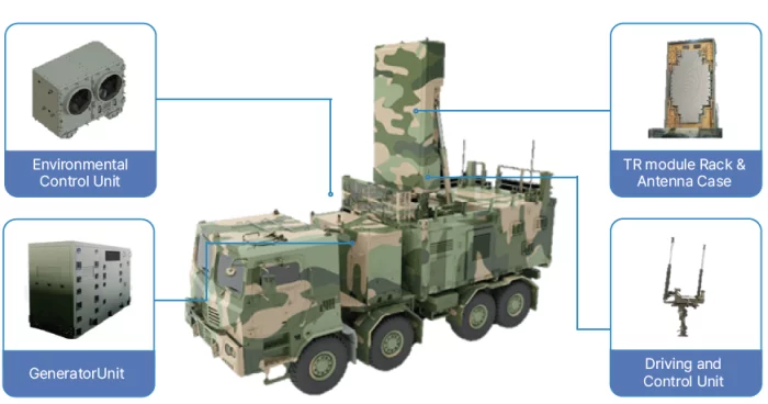
RF Systems
Weapon Locating Radar - II
Key RADAR in counter-fire warfare to defeat enemy artillery by reversely tracing the trajectory of ballistic missile.
Design and Manufacture
- Environmental Control Unit
- Driving unit
- Generator
- TR module rack & Antenna Case
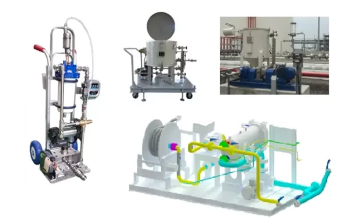
LEES Corporation
Aviation fuel refueling skid
aviation fuel refueling cart
: Mobile refueling cart that can easily refuel light aircraft and helicopters
Sump recovery system
: Collect the drained/sumped aviation fuel from the aviation fuel refueling system, easily sample and test it, and then decide whether to drain it or return it to the system.
Aviation fuel refueling system
: The aviation fuel refueling system is compactly constructed with a skid for easy use and installation.
Telcom International
RENAISSANCE
Low Insertion Loss, Good IMD Performance
RF Coaxial Switches: SPST to SP8T Switches, Transfer Switches from DC to 200 GHz
Power Dividers and Power Combiners
Wilkinson Types from 2 to 16 Ways
Frequency Range from 400 MHz to 26.5 GHz
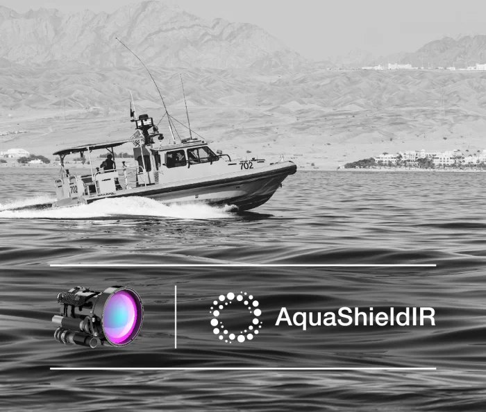
MKS Ophir
AquaShieldIR™ Hydrophobic Coating for IR Maritime and Naval Security &Surveillance
AquaShieldIR key benefits:
Water repellency: creates a water-repellent surface on IR imaging lenses, preventing water droplets from adhering. This feature ensures clarity and visibility, even in rainy or foggy conditions.
Enhanced visibility in wet conditions: by repelling water droplets, AquaShieldIR™ enables IR imaging lenses to perform optimally in wet conditions.
Improved Image Quality: thanks to the preventions of water droplets and contaminants from adhering to the lens surface, resulting in improved image quality.