한국어로 페이지 보기
Seoul ADEX 2025 Digital Directory
Plan your trip to Seoul ADEX 2025 using our state of the art Digital Directory
Register in seconds with just your email


Directory Features
To help you at the show
In-depth Exhibitor Profiles
Each exhibitor can add as many products and services as they wish, with in-depth information and specifications. This allows buyers to find what they want easily.
Self Provisioning for Exhibitors
Each exhibitor has full control of their content - to edit their company profile, upload products and enter staff details.
Plan your trip
Use the bookmarking and event planning tool to research the companies you would like to visit and the products you are interested in finding. You will be able to locate all of your saved companies on our floorplan
Advanced Search
Utilize our advanced search function to quickly locate products, people, and companies. Our state-of-the-art technology thoroughly scans all exhibitor information, delivering precise and relevant results
Interactive Floorplan
Navigate the show effortlessly with our directory. Use the floorplan to locate companies you want to visit and to find your way to onsite restaurants, toilets and site entrances and exits.
On-platform Messaging
Reach out to exhibitors and visitors directly on our platform to set up meetings, or request more information.
Some of our latest content
Companies, Products, News, Events
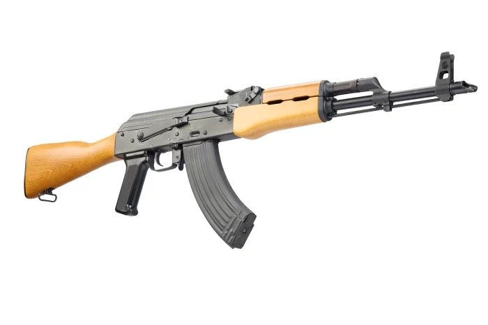
NOVA MODUL SRL
RAK1 M Rifle
A reliable, quality full or semi-auto version of the rifle that has written entire volumes in history.
A basic, non-nonsense version that stays true to the original.
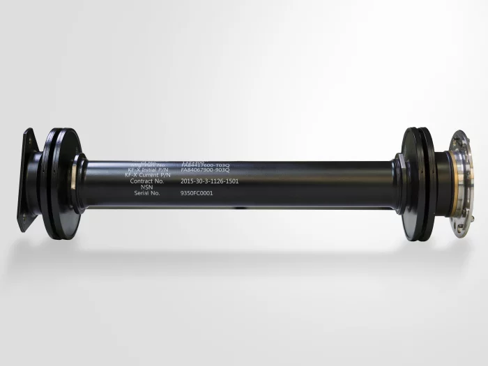
CTLA
KF-21 동력전달축(Power Take-Off Shaft)
PTO SHAFT, Proven Performance, Realized in Reality
CTLA's Power Transmission Shaft (PTO-shaft) is a key component of the aircraft secondary powertrain, transmitting the high-speed rotational power generated by the aircraft engine drive unit (EMAD) to the gearbox (AMAD).
By applying high-strength, lightweight titanium material for the first time in the world, we have achieved both weight reduction and durability, while implementing outstanding stability and reliability through our proprietary electron beam welding technology optimized for high-speed rotation and high-speed precision balancing technology.
In particular, this product, which is currently being mass-produced and delivered to the KF-21 fighter jet, has demonstrated excellent power transmission performance while minimizing vibration even in extreme environments.
CTLA is leading technological innovation in the field of high-speed rotational machinery, spearheading the self-reliance of domestic aircraft components and advancing into the global market.
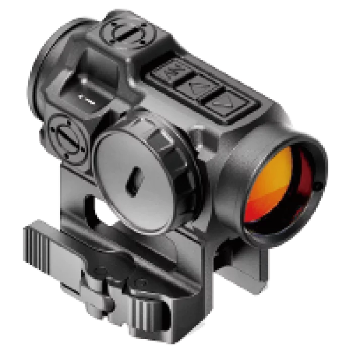
SU Optics
ACTUS® CORE-5 Dot Sight
The ACTUS® CORE-5 is the latest development of our Dot Sight lineup. It delivers the same high-end optical performance and legendary durability as our existing CORE Dot Sights, now with enhanced features based on feedback from professional users.
The ACTUS® CORE-5 offers three reticle designs and improved ergonomics, with relocated illumination controls on the top for ambidextrous operation—ensuring seamless adjustments while staying clear of chest rigs and plate carriers when slung.
A dedicated night vision override switch allows for instant adaptation to sudden lighting changes, while the CR2032 battery provides an impressive 20,000-hour runtime at Level 8 brightness.
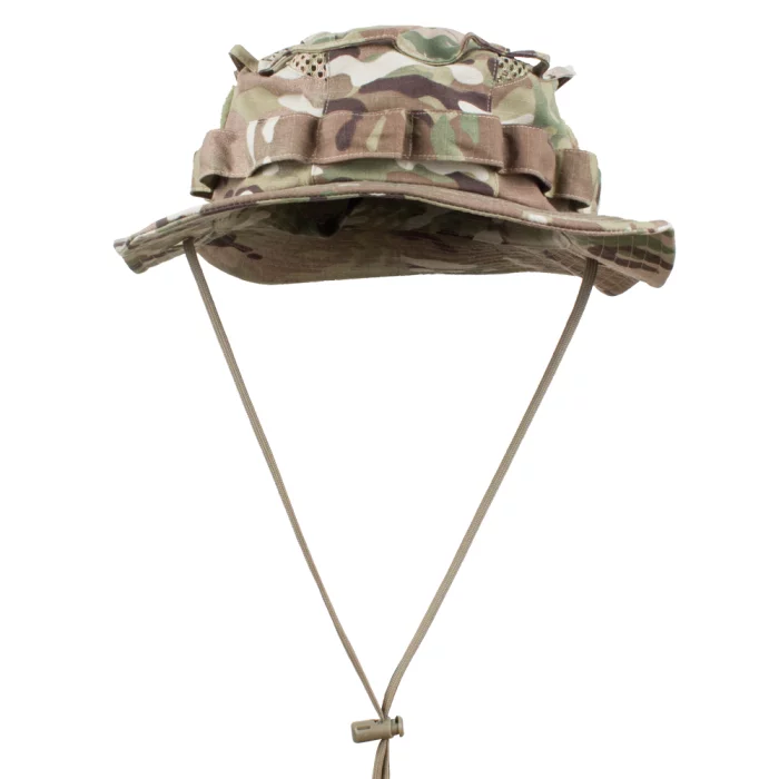
Hessed Korea
[MIF] Tactical Boonie Hat
Functional Military Boonie Hat Optimized for Mission Execution
The MIF Tactical Boonie Hat is a functional hat designed to ensure efficient mission performance in tactical operational environments. With both breathability and durability, it maintains wearer comfort even in harsh outdoor conditions and supports stable activity during operations.

View page in English


디렉터리 기능
전시회 도우미
In-depth Exhibitor Profiles
Each exhibitor can add as many products and services as they wish, with in-depth information and specifications. This allows buyers to find what they want easily.
Self Provisioning for Exhibitors
Each exhibitor has full control of their content - to edit their company profile, upload products and enter staff details.
방문 계획 수립
북마크 도구와 이벤트 플래너를 사용해 방문하고자 하는 기업과 관심 있는 제품을 검색하세요. 저장한 모든 항목을 조회할 수 있습니다
고급 검색
고급 검색 기능을 사용하여 상품, 인물, 기업의 위치를 빠르게 조회할 수 있습니다. 최첨단 기술을 통해 모든 참가사의 정보를 철저히 스캔하여 세밀하고 관련성 있는 정보를 제공합니다
상호작용 가능 평면도
디렉터리를 사용해 전시회를 손쉽게 둘러보세요. 방문하고자 하는 기업의 위치와, 행사장 내 식당, 화장실, 출입구를 평면도에서 찾을 수 있습니다.
플랫폼 내 메시지
플랫폼 상의 전시 참가사와 관람객에게 직접 연락하여 미팅을 신청하거나 추가 정보를 요청하세요.
최신 콘텐츠
기업, 상품, 뉴스, 이벤트

Haigh-Farr, Inc.
Haigh-Farr - Products
Since 1969 providing mission critical antennas and support equipment to the defense, aerospace, and commercial industries worldwide.
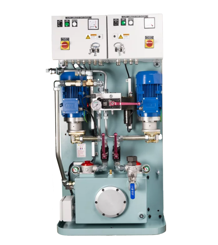
HANMI HYDRAULIC MACHINERY CO., LTD.
Booster Pump Station
Original compact design and long-term production know-how.
System reliability and overall competitiveness.
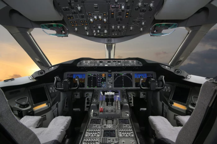
Ho-Ho-Kus, Inc.
Cockpits
We manufacturer hardware securing instrumentation including fasteners along with avionics trays, associated shock mounts and vibration dampeners.
_700.webp)
Arion Communication Co., Ltd.
TYTO 6
The device consists of a power supply, dedicated Iridium and GNSS antenna, BLE, three configurable inputs/outputs, RS232, and CANbus in an environmentally sealed enclosure. Includes an Iridium Short Burst Data (SBD) modem that allows remote devices to send and receive satellite messages from anywhere in the world.