한국어로 페이지 보기
Seoul ADEX 2025 Digital Directory
Plan your trip to Seoul ADEX 2025 using our state of the art Digital Directory
Register in seconds with just your email


Directory Features
To help you at the show
In-depth Exhibitor Profiles
Each exhibitor can add as many products and services as they wish, with in-depth information and specifications. This allows buyers to find what they want easily.
Self Provisioning for Exhibitors
Each exhibitor has full control of their content - to edit their company profile, upload products and enter staff details.
Plan your trip
Use the bookmarking and event planning tool to research the companies you would like to visit and the products you are interested in finding. You will be able to locate all of your saved companies on our floorplan
Advanced Search
Utilize our advanced search function to quickly locate products, people, and companies. Our state-of-the-art technology thoroughly scans all exhibitor information, delivering precise and relevant results
Interactive Floorplan
Navigate the show effortlessly with our directory. Use the floorplan to locate companies you want to visit and to find your way to onsite restaurants, toilets and site entrances and exits.
On-platform Messaging
Reach out to exhibitors and visitors directly on our platform to set up meetings, or request more information.
Some of our latest content
Companies, Products, News, Events
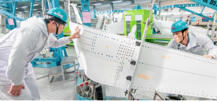
Korean Air (KAL)
Aerostructure
We has built a global partnership with accumulated technology to produce/supply major structures to Boeing and Airbus.
By manufacturing large-scale composites that make the fuselarge of an aircraft, automated production technology applying robot concepts, non-destructive inspection technology and flow production line, etc. we are competing with advanced aircraft manufacturers with the best technology, quality and productivity by developing advanced technologies and equipment.
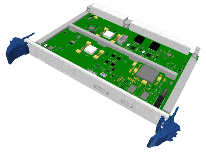
SeedCore
SCVPX-SSGM(Synchronous Signal Generation Module)
The SCVPX-SSGM (Synchronous Signal Generation Module) generates synchronization signals to coordinate the operation and timing of various radar system components.
It can generate synchronization signals using an internal clock, receive an external clock, or regenerate synchronization signals from external sources to maintain precise timing cycles.
A device driver program is required for configuration and operation, and the Linux driver can be downloaded from Seedcore’s product page.
Drivers for other operating systems can be developed upon request.
This module is deployed in the L-SAM multi-function radar system, providing precise timing synchronization across mission-critical subsystems.
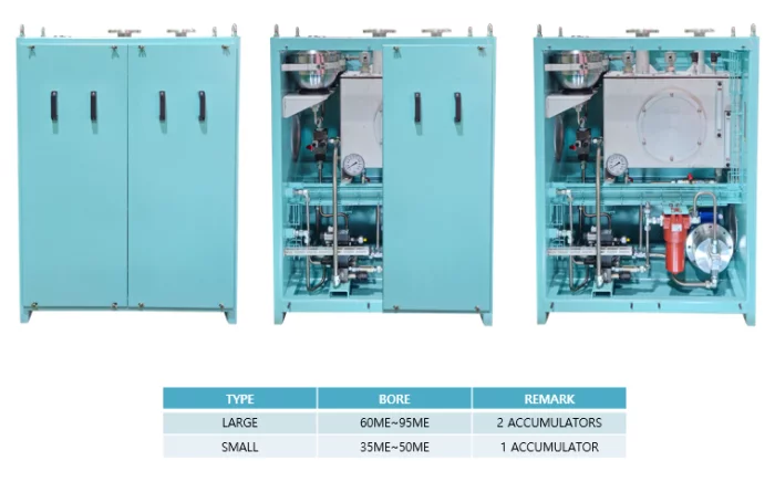
HANMI HYDRAULIC MACHINERY CO., LTD.
Sealing Oil Unit(SOU)
This unit(SOU) supplies sealing oil to prevent mixing of hydraulic oil and liquefied methanol gas inside of FBIV(Fuel Booster Injection Valve) when the main engine operates.
SOU is divided into large bore main engine(60 bore over) and small bore main engine(50 bore below) type by the number of membrane accumulator. The main components consist of an oil tank, an electric motor, a hydraulic gear pump, an oil filter, a control block, accumulators, and various senses, transmitters and indicators.
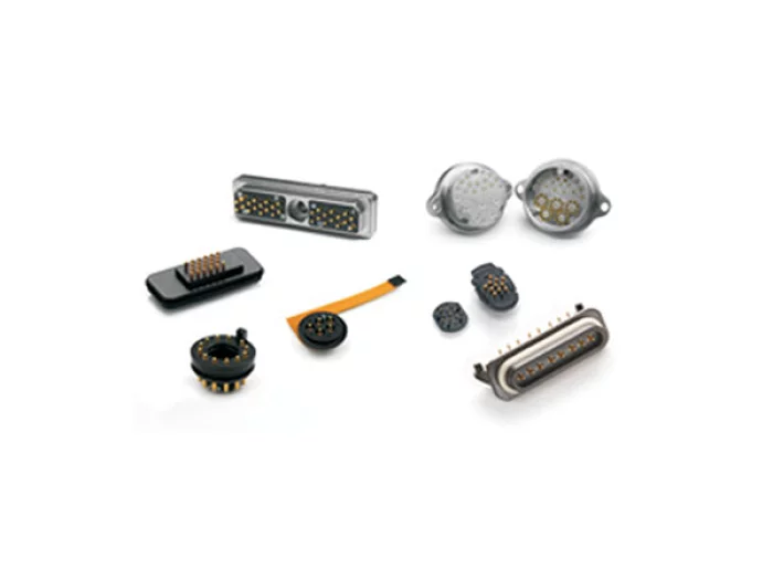
Sangdo Electronics co.,Ltd
Custom Spring Probe Connectors
Spring probes are designed to optimize performance in high reliability, multicycle applications. Smiths Interconnect’s spring probes are compliant which makes them ideal for blind mate applications as they self correct for x, y, z, rotational and angular misalignment of the target. Offered in compressed heights less than 2 mm and utilized on pitches as tight as 0.4 mm, they are well suited for high density, board-to-board, battery contact and high frequency applications. Mixed signals and functionality can be designed into a single connector.

View page in English


디렉터리 기능
전시회 도우미
In-depth Exhibitor Profiles
Each exhibitor can add as many products and services as they wish, with in-depth information and specifications. This allows buyers to find what they want easily.
Self Provisioning for Exhibitors
Each exhibitor has full control of their content - to edit their company profile, upload products and enter staff details.
방문 계획 수립
북마크 도구와 이벤트 플래너를 사용해 방문하고자 하는 기업과 관심 있는 제품을 검색하세요. 저장한 모든 항목을 조회할 수 있습니다
고급 검색
고급 검색 기능을 사용하여 상품, 인물, 기업의 위치를 빠르게 조회할 수 있습니다. 최첨단 기술을 통해 모든 참가사의 정보를 철저히 스캔하여 세밀하고 관련성 있는 정보를 제공합니다
상호작용 가능 평면도
디렉터리를 사용해 전시회를 손쉽게 둘러보세요. 방문하고자 하는 기업의 위치와, 행사장 내 식당, 화장실, 출입구를 평면도에서 찾을 수 있습니다.
플랫폼 내 메시지
플랫폼 상의 전시 참가사와 관람객에게 직접 연락하여 미팅을 신청하거나 추가 정보를 요청하세요.
최신 콘텐츠
기업, 상품, 뉴스, 이벤트

Lockheed Martin Corporation
Lockheed Martin Product Information
Current list of Lockheed Martin products.
Syscom Korea Co., Ltd.
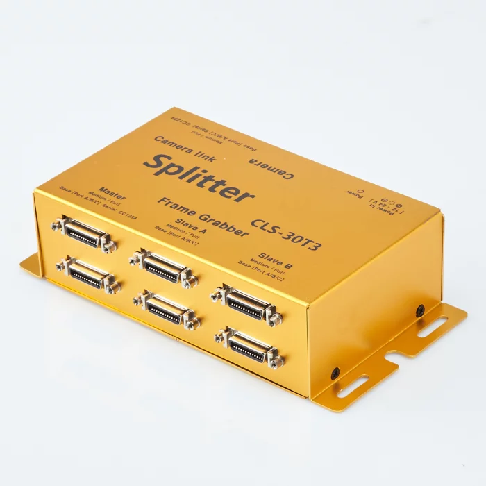
1:3 Camera Link Signal Distribution Splitter , CLS-30T3 ,Base, Medium, Full configuration
Main Features of CLS-30T3
Camera Link Compatibility: Supports all Camera Link types (Area Scan / Line Scan).
Video Distribution: 1:3 distribution capability supporting Base, Medium, and Full configurations.
Power over Camera Link (PoCL): Performs PoCL Bypass functionality.
Pixel Frequency: Supports a pixel frequency range of 20 MHz to 85 MHz.
Transmission Quality: Ensures lossless video signal transmission.
Power Connector: Equipped with a lockable DC power jack (Molex connector).
Interface: Supports MDR-26 type connectors.
Control Signal Support: Supports all standard RS-232 communication speeds.

NINANO COMPANY INC.
GOSHAWK
Its unique tail-sitter design enables vertical takeoff and landing while maintaining fixed-wing efficiency during flight. The drone achieves high-speed performance and extended flight distances, making it ideal for wide-area monitoring. With its advanced endurance and adaptability, GOSHAWK delivers reliable intelligence in both tactical and strategic operations.
_700.webp)
Green Optics Co., Ltd.
ZnS Matetial
Green Optics possess proprietary CVD-based Zinc Sulfide (ZnS) production technology for defense and industrial multi-wavelength optical materials. We have core technological capabilities to manufacture high-quality ZnS products tailored to meet diverse customer requirements.
ZnS Material Optical Performance and Processing
ZnS materials produced through CVD processes provide high transmittance exceeding 70% in the SWIR wavelength range (8-12 μm). When these materials undergo additional Hot Isostatic Pressing (HIP) treatment, the crystal structure undergoes recrystallization, improving transmission characteristics to achieve over 70% transmittance in the visible (VIS) wavelength range of 0.45-0.8 μm. This process extends the application range of optical materials previously limited to SWIR and LWIR bands, delivering superior optical performance across multi-wavelength regions from VIS to LWIR.
Material Specifications:
- STD-ZnS (Standard ZnS Material): Manufactured via CVD process, exhibits transmittance exceeding 70% in LWIR wavelengths (8-12 μm) with high physical hardness (Knoop hardness: 210 kgf/mm²).
- MS-ZnS (Multispectral ZnS): Converted from STD-ZnS through HIP processing, extends wavelength range into the visible spectrum. While crystal structure recrystallization during this process reduces hardness somewhat (approximately 150 kgf/mm²), it still meets MIL specifications.
This dual-processing approach enables comprehensive wavelength coverage while maintaining military-grade durability standards.