한국어로 페이지 보기
Seoul ADEX 2025 Digital Directory
Plan your trip to Seoul ADEX 2025 using our state of the art Digital Directory
Register in seconds with just your email


Directory Features
To help you at the show
In-depth Exhibitor Profiles
Each exhibitor can add as many products and services as they wish, with in-depth information and specifications. This allows buyers to find what they want easily.
Self Provisioning for Exhibitors
Each exhibitor has full control of their content - to edit their company profile, upload products and enter staff details.
Plan your trip
Use the bookmarking and event planning tool to research the companies you would like to visit and the products you are interested in finding. You will be able to locate all of your saved companies on our floorplan
Advanced Search
Utilize our advanced search function to quickly locate products, people, and companies. Our state-of-the-art technology thoroughly scans all exhibitor information, delivering precise and relevant results
Interactive Floorplan
Navigate the show effortlessly with our directory. Use the floorplan to locate companies you want to visit and to find your way to onsite restaurants, toilets and site entrances and exits.
On-platform Messaging
Reach out to exhibitors and visitors directly on our platform to set up meetings, or request more information.
Some of our latest content
Companies, Products, News, Events
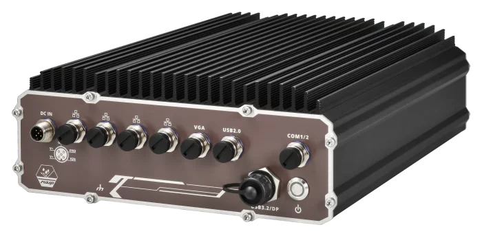
NeXber Co., Ltd.
Nuvo-9650AWP Series
Intel® 14th/13th/12th-Gen Core™ 24C/ 32T 35W/ 65W CPU
Affordable IP66-rated design for waterproof and dustproof Up to 96GB DDR5 4800 SODIMM
-25°C to 70°C wide-temperature fanless operation
3x 2.5Gb and 1x Gb Ethernet ports via M12 X-coded connectors, with 802.3at PoE+ option
1x waterproof USB3.2 Type-C port supporting alternative mode for DisplayPort and USB3.2 dual output
8V to 48V DC input with built-in ignition power control
_700.webp)
IR Robot Co.,Ltd.
mightyZAP 17Lf series micro linear servo actuators
- Compact size with built-in drive, position sensor, DC motor and gear box
- Better durability & faster speed under similar rated load comparing to 12Lf series thanks to the bigger 17mm diameter DC motor
- Position, current and speed control along with position & current feedback
- Easy digital extended I/O control through 4 x Expansion I/O ports (No coding)
- 27/37/50/87mm(*) stroke option
(*): Each 3mm stroke can be added when adjusting the long stroke limit through Total Manager software.
Rated load of 17N~70N depending on the lead angle for each stroke
(Speed is inversely proportional to the rated load, so the higher the rated load, the slower the speed.)
- RS-485 MODBUS-RTU protocol applied (IR open protocol is not provided)
- Action feature which enables user’s motion save & run
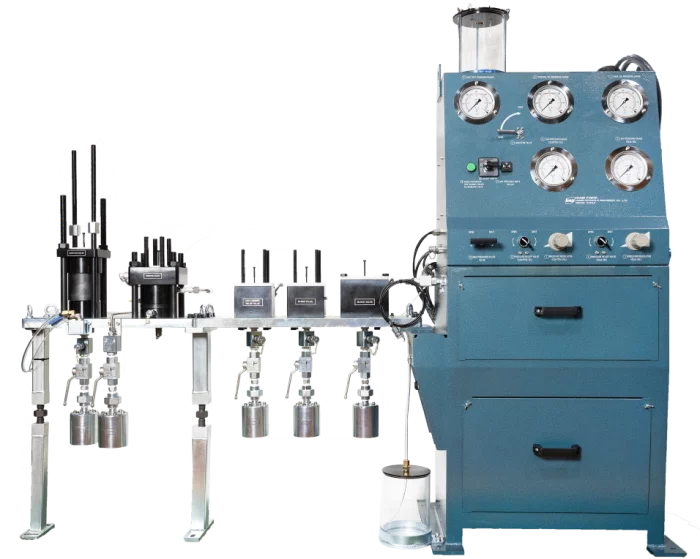
HANMI HYDRAULIC MACHINERY CO., LTD.
Fuel Valve Test Device
This product is a test-rig to test the injection and function of various fuel (diesel oil, gas) objects of the main engine. This product model is made from slide fuel valve types of traditional diesel engines to latest dual fuel gas engines GI, GI, LGIP, LGIM/X-DFM, and ammonia fuel valve engines LGIA and X-DFA types, and we are directly doing everything from design to production.
In accordance with the maintenance regulations recommended by Everllence and WIN GD, it is a product that tests the normal functionality of fuel injectors of main engine after disassembling, cleaning and reassembling of fuel injection valves.

Saab
BOL Countermeasures Dispenser System
Saab's Electronic Warfare (EW) Countermeasure Dispensing Systems (CMDS) for airborne platforms provides self-protection in sophisticated, diverse and dense threat environments for your mission success and safe returns.

View page in English


디렉터리 기능
전시회 도우미
In-depth Exhibitor Profiles
Each exhibitor can add as many products and services as they wish, with in-depth information and specifications. This allows buyers to find what they want easily.
Self Provisioning for Exhibitors
Each exhibitor has full control of their content - to edit their company profile, upload products and enter staff details.
방문 계획 수립
북마크 도구와 이벤트 플래너를 사용해 방문하고자 하는 기업과 관심 있는 제품을 검색하세요. 저장한 모든 항목을 조회할 수 있습니다
고급 검색
고급 검색 기능을 사용하여 상품, 인물, 기업의 위치를 빠르게 조회할 수 있습니다. 최첨단 기술을 통해 모든 참가사의 정보를 철저히 스캔하여 세밀하고 관련성 있는 정보를 제공합니다
상호작용 가능 평면도
디렉터리를 사용해 전시회를 손쉽게 둘러보세요. 방문하고자 하는 기업의 위치와, 행사장 내 식당, 화장실, 출입구를 평면도에서 찾을 수 있습니다.
플랫폼 내 메시지
플랫폼 상의 전시 참가사와 관람객에게 직접 연락하여 미팅을 신청하거나 추가 정보를 요청하세요.
최신 콘텐츠
기업, 상품, 뉴스, 이벤트
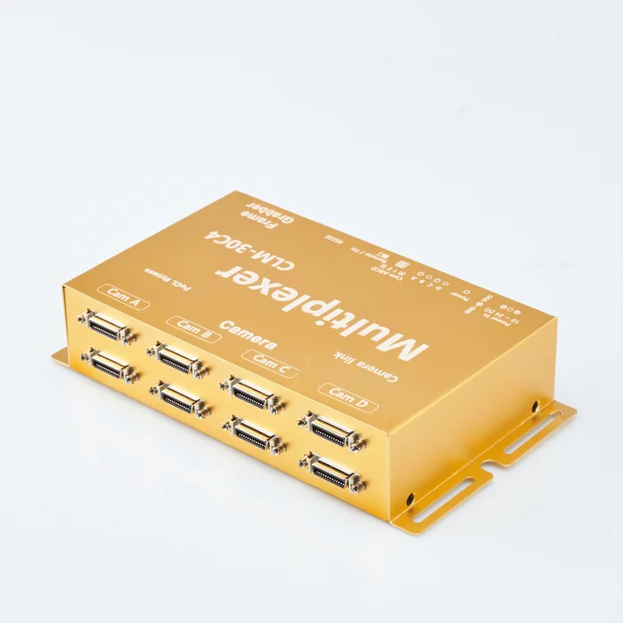
Syscom Korea Co., Ltd.
4:1 Camera link Multiplexer ( Camera Selector) CLM-30C4 , Base/Medium/Full configuration
The maximum transmission distance varies based on the following frequency-related specifications.
Camera Frequency Max Cable Length
================ ===============
20 ~ 60 MHz 10 m
60 ~ 80 MHz 7 m
80 ~ 85 MHz 5 m
The PoCL Bypass function supports Power over Camera Link (PoCL) operation from the Frame Grabber to the selected camera. However, the power supply to unselected cameras is automatically disabled. To prevent power cutoff, separate power must be provided to the cameras. Configurations are available as follows, including image signal amplification.
[Features of CLM-30C4]
Fully supports the Camera Link interface (Area/Line Scan).
Provides manual (switch) or remote (RS232) camera selection.
Allows selection from one of four cameras configured for Base (Layer 1) or Medium/Full (Layer 2) levels.
Supports Base/Medium/Full setups (CC1~4, RS232, LVAL, DVAL, FVAL)
PoCL bypass function: Automatically powers only the selected camera when PoCL-compatible cameras, frame grabbers, and cables are used.
Supports pixel frequency from 20 to 85 MHz.
Supports PoCL signal bypass (patented).
Enables lossless transmission.
Provides additional full-duplex RS232 communication at up to 256 Kbps.
Features a locking DC power jack (Molex).

nLIGHT Inc
C-UAS 30kW SBC HEL Source
C-UAS 30kW SBC HEL Source

Honeywell International
4 Drone Challenges - and How to Solve Them
Delivering dinner to your door. Bringing medical supplies to hospitals. Surveying waters where someone is missing. Drones are starting to help make many tasks faster and life a little easier. One hitch in using drones is that, in most cases, regulators in many countries require that a human keep them in sight at all times.

PSIONdsp
Cockpit Display & Instrument HDB0800SG
HDB0800SG is a HUD (Head Up Display) Repeater installed in fixed wing of Korean Air Force, which shows video information given from the cockpit HUD to the rear seat.