한국어로 페이지 보기
Seoul ADEX 2025 Digital Directory
Plan your trip to Seoul ADEX 2025 using our state of the art Digital Directory
Register in seconds with just your email


Directory Features
To help you at the show
In-depth Exhibitor Profiles
Each exhibitor can add as many products and services as they wish, with in-depth information and specifications. This allows buyers to find what they want easily.
Self Provisioning for Exhibitors
Each exhibitor has full control of their content - to edit their company profile, upload products and enter staff details.
Plan your trip
Use the bookmarking and event planning tool to research the companies you would like to visit and the products you are interested in finding. You will be able to locate all of your saved companies on our floorplan
Advanced Search
Utilize our advanced search function to quickly locate products, people, and companies. Our state-of-the-art technology thoroughly scans all exhibitor information, delivering precise and relevant results
Interactive Floorplan
Navigate the show effortlessly with our directory. Use the floorplan to locate companies you want to visit and to find your way to onsite restaurants, toilets and site entrances and exits.
On-platform Messaging
Reach out to exhibitors and visitors directly on our platform to set up meetings, or request more information.
Some of our latest content
Companies, Products, News, Events
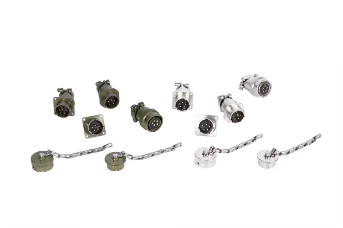
Jaewon Korea
MIL-DTL-26482 Series Ⅰ
Fast connection and disconnection are possible, and it provides a stable connection against vibration or shock.
It is IP67-grade waterproof and can be used in humid or dusty environments.
It also provides the ability to shield electromagnetic interference (EMI).
Key uses:
Military communications equipment, orbital vehicles and rail vehicles, aerospace industry, electric vehicles and unmanned systems, industrial equipment.
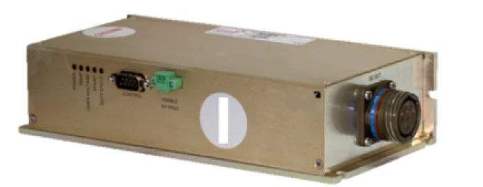
Duratek
Motor Drive power supply
Duratek’s motor drive power supply is engineered to absorb excess energy during motor regeneration and braking phases, ensuring consistent and stable voltage delivery.
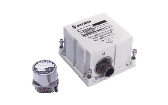
SAFRAN
ICONYX
ICONYX™ is a high-performance tactical grade Inertial Measurement Unit (IMU) for guidance and control applications. ICONYX™ is designed to meet the most demanding environmental conditions with extreme accuracy and reliability. Proven Technology Safran proposes an IMU based on Hemispherical Resonator Gyroscope the HRG Crystal™. This technology is combat proven for 15 years and is extremely accurate, reliable, and is capable of navigating in the most contested GNSS denied environments. HRG Crystal™ Embedded Thanks to the HRG Crystal™, ICONYX™ surpasses the highest performances of its category while keeping the best in class SWaP (Size, Weight, and Power) characteristics of the market. High performance in demanding environments ICONYX™ includes 3 hemispherical resonator gyroscopes HRG Crystal ™ and 3 closed loop MEMS (Micro Electro Mechanical Systems) accelerometers in a compact package. Both Safran’s gyroscopes and Safran’s accelerometers are technological breakthrough.
_700.webp)
MKS Ophir
Large-mirror optical components design & production
Large mirrors are crucial in various optical systems, particularly long-range multi-spectral setups for defense, surveillance, and commercial use, like UAV optics and agricultural temperature monitoring. Aerospace applications, such as satellites and telescopes, are common. These mirrors come in different shapes and materials, including Al, Si, Ge, and Cu, spanning visible, UV, and IR spectrums.
By using advanced CNC grinding, polishing, and diamond turning we provide precise surface forms, with tight tolerances, and multispectral performance. Our mirrors, up to 700mm in diameter, provide impressive specifications: 0.05% radius tolerance, less than 0.5Fr P-V irregularities, 0.1Fr RMS at 0.633μ, and sub-40Å RMS roughness. MKS Ophir's proprietary coatings enhance spectral performance and surface durability.
Contact us to set a meeting at ADEX Seoul

View page in English


디렉터리 기능
전시회 도우미
In-depth Exhibitor Profiles
Each exhibitor can add as many products and services as they wish, with in-depth information and specifications. This allows buyers to find what they want easily.
Self Provisioning for Exhibitors
Each exhibitor has full control of their content - to edit their company profile, upload products and enter staff details.
방문 계획 수립
북마크 도구와 이벤트 플래너를 사용해 방문하고자 하는 기업과 관심 있는 제품을 검색하세요. 저장한 모든 항목을 조회할 수 있습니다
고급 검색
고급 검색 기능을 사용하여 상품, 인물, 기업의 위치를 빠르게 조회할 수 있습니다. 최첨단 기술을 통해 모든 참가사의 정보를 철저히 스캔하여 세밀하고 관련성 있는 정보를 제공합니다
상호작용 가능 평면도
디렉터리를 사용해 전시회를 손쉽게 둘러보세요. 방문하고자 하는 기업의 위치와, 행사장 내 식당, 화장실, 출입구를 평면도에서 찾을 수 있습니다.
플랫폼 내 메시지
플랫폼 상의 전시 참가사와 관람객에게 직접 연락하여 미팅을 신청하거나 추가 정보를 요청하세요.
최신 콘텐츠
기업, 상품, 뉴스, 이벤트
_700.webp)
FOSTEC Inc.
Fiber Optic Pin Terminal (MIL-PRF-29504/4D)
FOSTEC optical fiber pin/socket terminals are designed to connect to each other through physical contact. POSTECH's unique alignment technology maximizes optical performance and provides reliability.
_700.webp)
BELL Textron Inc.
Bell 505
The sky’s the limit with the Bell 505. A high-tech flight deck and adaptable cabin design make it an extremely cost-competitive, and capable for any challenge.
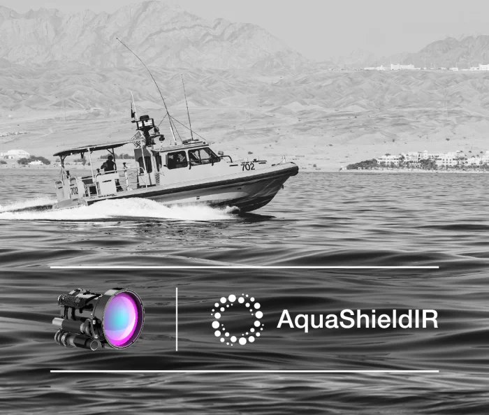
MKS Ophir
AquaShieldIR™ Hydrophobic Coating for IR Maritime and Naval Security &Surveillance
AquaShieldIR key benefits:
Water repellency: creates a water-repellent surface on IR imaging lenses, preventing water droplets from adhering. This feature ensures clarity and visibility, even in rainy or foggy conditions.
Enhanced visibility in wet conditions: by repelling water droplets, AquaShieldIR™ enables IR imaging lenses to perform optimally in wet conditions.
Improved Image Quality: thanks to the preventions of water droplets and contaminants from adhering to the lens surface, resulting in improved image quality.

Abaco Systems
SWE550S
The SWE550S is a rugged 6U VPX fully managed Layer-2/3 Ethernet switch aligned with the SOSA profile, providing blazing-fast 25/100 GbE switching via a 3.2 Tbps fabric and flexible I/O reconfiguration.
• 3.2 Tbps switch fabric delivering full wire-speed bandwidth (~2.5× typical)
• Front: up to 2×100 GBASE-SR4 (MPO); Rear: up to 7×100 GBASE-SR4, SWE540A-compatible I/O
• Fat-pipe ports reconfigurable into thin-pipe ports; copper ports support 25/100→10/40 Gb speed downgrade
• Dual-core ARM + OpenWare™ management; built-in storage sanitization
• SOSA-aligned 6U VPX form factor; air & conduction cooled; rugged Levels 1, C, E