한국어로 페이지 보기
Seoul ADEX 2025 Digital Directory
Plan your trip to Seoul ADEX 2025 using our state of the art Digital Directory
Register in seconds with just your email


Directory Features
To help you at the show
In-depth Exhibitor Profiles
Each exhibitor can add as many products and services as they wish, with in-depth information and specifications. This allows buyers to find what they want easily.
Self Provisioning for Exhibitors
Each exhibitor has full control of their content - to edit their company profile, upload products and enter staff details.
Plan your trip
Use the bookmarking and event planning tool to research the companies you would like to visit and the products you are interested in finding. You will be able to locate all of your saved companies on our floorplan
Advanced Search
Utilize our advanced search function to quickly locate products, people, and companies. Our state-of-the-art technology thoroughly scans all exhibitor information, delivering precise and relevant results
Interactive Floorplan
Navigate the show effortlessly with our directory. Use the floorplan to locate companies you want to visit and to find your way to onsite restaurants, toilets and site entrances and exits.
On-platform Messaging
Reach out to exhibitors and visitors directly on our platform to set up meetings, or request more information.
Some of our latest content
Companies, Products, News, Events
_700.webp)
BELL Textron Inc.
Bell 412
When your missions take you into extreme environments, the Bell 412 will always have your back. With the cabin you need for passengers and cargo, nothing and no one will get left behind.
_700.webp)
SJPrecision
Connector parts
SJP’s connector components are designed and manufactured to meet the highest standards of precision and reliability across industries.
Equipped with state-of-the-art CNC multi-tasking machines and extensive know-how, we deliver solutions ranging from fine threading to complex geometries.
Our connectors are widely applied in electronics, medical devices, aerospace, and defense, where durability and stable connectivity are critical.
Through customized design services and fast lead times, we help our clients enhance their product competitiveness.
funzin
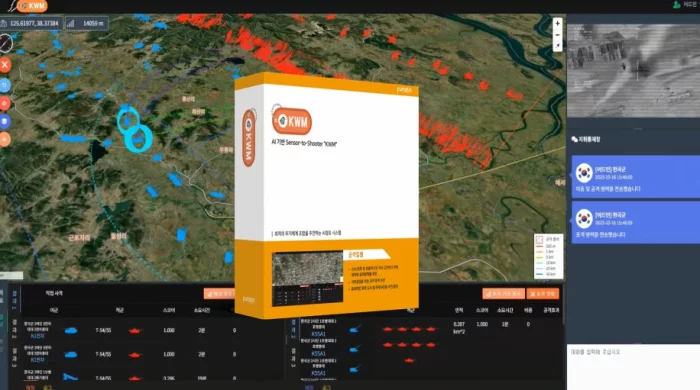
KWM : Kill Web Matching
Solution Overview
The AI-Based Command Decision Support System, "KWM," identifies battlefield targets and recommends optimal weapon system combinations. It supports end-to-end "Sensor-to-Shooter" execution for rapid, accurate, and efficient engagement and command decision-making.
Main Features
Identifies targets on the battlefield using integrated sensors and data
Recommends the most effective attack strategies for both reconnaissance and attack missions
Provides command decision support through real-time analysis and visualization
Suggests and allocates optimal target formations and strike assets
Supports on-site command and control with a user-friendly interface
Key Advantages
Enables quick, accurate, and efficient engagement of enemy targets
Automated recommendation of attack strategies and allocation of strike resources
Real-time synchronization between reconnaissance and attack kill webs
Direct connection from detection to strike (Sensor-to-Shooter capability)
Increases operational efficiency and decision-making accuracy in complex battlefield environments
Applied Cases
Successfully piloted in the Army Tiger Boost Project in 2024
Used for command decision-making and efficient allocation of attack resources in live military scenarios
SM CNS
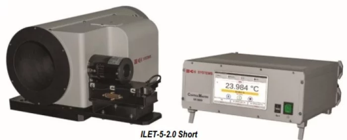
ILET
CI Systems사의 는 I-레벨 광학 테스트 및 실험실 테스트를 수행하는 데 이상적인 장비입니다.
소형이기 때문에 휴대 가능하며, 컴퓨터화되어있어 차량에 설치할 수 있습니다. 열화상 장비 및 가시광 센서에 대한 종합적인 테스트를 현장에서 할 수 있어 D-레벨 시설 없이도 테스트를 효율적으로 수행할 수 있습니다.
콜리메이터, 방사선원(블랙바디, 가시광 광원), 타깃 휠(수동 또는 전동)로 구성되며, CI Systems의 CTE 소프트웨어와 연동 시 간편하고 객관적이며 반복성을 극대화한 테스트가 가능합니다.
환경 변화에도 높은 정확도를 유지하며, 환경 챔버 테스트, 생산 라인 테스트, 현장 테스트 등 다양한 환경에서 활용할 수 있습니다.
The CI Systems ILET (Intermediate-Level Electro-Optical Tester) family of test systems is ideally suited for performing I-level optical tests and laboratory testing.
Portable, compact and computerized, ILET testers can be installed on a vehicle, bringing comprehensive testing of thermal imagers and visible light sensors to the field, reducing the need of D-Level facilities.
The basic ILET configuration includes a collimator, a radiation source (blackbody and/or visible light source) and a target wheel (manual or motorized).
The ILET is easy to use when interfaced with CI Systems’ CTE software (optional), minimizing testing turnaround time and maximizing testing objectivity and repeatability.
The testers retain their accuracy over a wide range of ambient temperatures. Thanks to the ILET’s outstanding features and versatility, it is useful in a variety of applications such as testing in environmental chambers, testing on production lines and testing in the field..

View page in English


디렉터리 기능
전시회 도우미
In-depth Exhibitor Profiles
Each exhibitor can add as many products and services as they wish, with in-depth information and specifications. This allows buyers to find what they want easily.
Self Provisioning for Exhibitors
Each exhibitor has full control of their content - to edit their company profile, upload products and enter staff details.
방문 계획 수립
북마크 도구와 이벤트 플래너를 사용해 방문하고자 하는 기업과 관심 있는 제품을 검색하세요. 저장한 모든 항목을 조회할 수 있습니다
고급 검색
고급 검색 기능을 사용하여 상품, 인물, 기업의 위치를 빠르게 조회할 수 있습니다. 최첨단 기술을 통해 모든 참가사의 정보를 철저히 스캔하여 세밀하고 관련성 있는 정보를 제공합니다
상호작용 가능 평면도
디렉터리를 사용해 전시회를 손쉽게 둘러보세요. 방문하고자 하는 기업의 위치와, 행사장 내 식당, 화장실, 출입구를 평면도에서 찾을 수 있습니다.
플랫폼 내 메시지
플랫폼 상의 전시 참가사와 관람객에게 직접 연락하여 미팅을 신청하거나 추가 정보를 요청하세요.
최신 콘텐츠
기업, 상품, 뉴스, 이벤트
_700.webp)
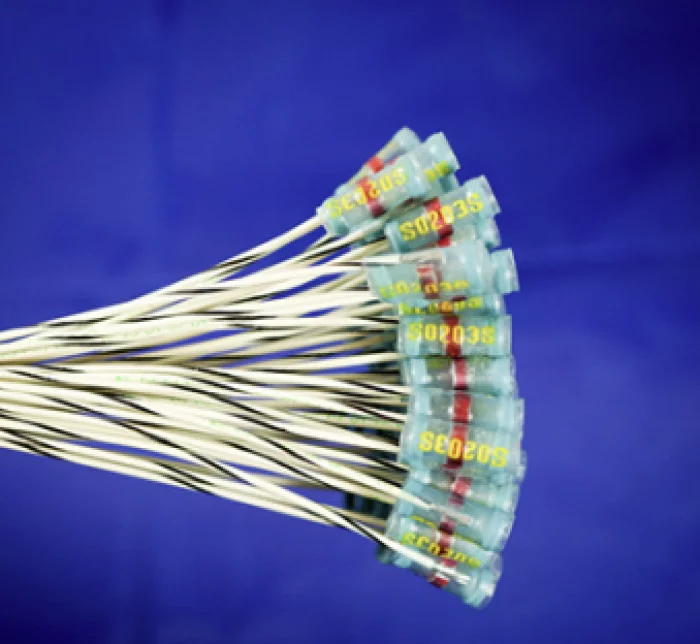
SeA Electronics Co., Ltd.
Cable Assembly
Designed and manufactured to ensure flawless connection between precision striking functions, even in extreme temperatures, varying altitudes, and impact environments.
BIBUS METALS KOREA
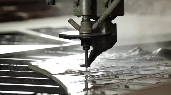
Cutting by water jet
[Cutting by water jet]
Micro water jet cutting:
The micro water jet enables a refined process to be carried out in precision cutting. This high-precision technology reduces the jet diameter by a factor of 5 and makes water jet cutting more precise by a factor of 10. The micro water jet achieves a cutting accuracy of +/- 0.01 mm and a positioning accuracy of ±0.005 mm. The proven advantages of the cold cutting process remain unchanged.
In the pure water process, the cutting width was reduced to 0.2 mm in the abrasive process for hard materials such as nickel-based alloys and titanium. The new technology controls the cutting process and manipulates the cutting path depending on the contour and speed enabling a highly precise cut.
Standard waterjet cutting:
Water jet cutting is highly efficient and at the same time less severe than other cutting techniques. Low process forces and thermal loads prevent bending or melting. We can cut filigree delicate contours from practically all nickel alloys and titanium alloys. Using our standard process we can cut a range of shapes and dimensions according to customer requirements and drawings and achieve tolerances of +/- 0.1 mm or +/- 0.2 mm.
WIREMASTERS
SLEEVE
A sleeve in military or aerospace applications is a protective covering used for wiring harnesses and cables
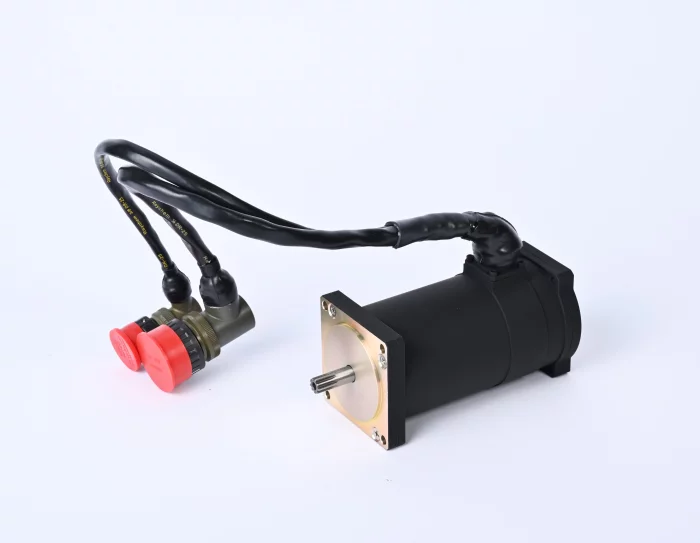
KAES
[KF-21 Fighter Jet] Canopy Actuation System (CAS) Motor
An electric motor that supplies power to the actuator for opening and closing the KF-21 canopy.