한국어로 페이지 보기
Seoul ADEX 2025 Digital Directory
Plan your trip to Seoul ADEX 2025 using our state of the art Digital Directory
Register in seconds with just your email


Directory Features
To help you at the show
In-depth Exhibitor Profiles
Each exhibitor can add as many products and services as they wish, with in-depth information and specifications. This allows buyers to find what they want easily.
Self Provisioning for Exhibitors
Each exhibitor has full control of their content - to edit their company profile, upload products and enter staff details.
Plan your trip
Use the bookmarking and event planning tool to research the companies you would like to visit and the products you are interested in finding. You will be able to locate all of your saved companies on our floorplan
Advanced Search
Utilize our advanced search function to quickly locate products, people, and companies. Our state-of-the-art technology thoroughly scans all exhibitor information, delivering precise and relevant results
Interactive Floorplan
Navigate the show effortlessly with our directory. Use the floorplan to locate companies you want to visit and to find your way to onsite restaurants, toilets and site entrances and exits.
On-platform Messaging
Reach out to exhibitors and visitors directly on our platform to set up meetings, or request more information.
Some of our latest content
Companies, Products, News, Events
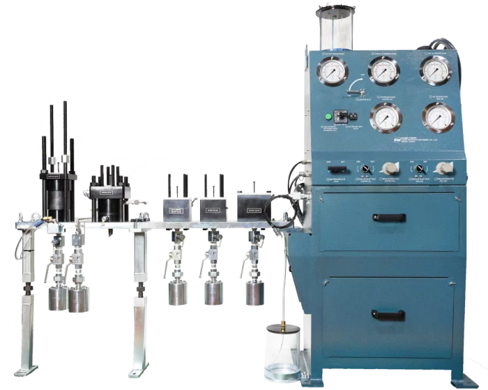
HANMI HYDRAULIC MACHINERY CO., LTD.
Fuel Valve Test Device
This product is a test-rig to test the injection and function of various fuel (diesel oil, gas) objects of the main engine. This product model is made from slide fuel valve types of traditional diesel engines to latest dual fuel gas engines GI, GI, LGIP, LGIM/X-DFM, and ammonia fuel valve engines LGIA and X-DFA types, and we are directly doing everything from design to production.
In accordance with the maintenance regulations recommended by Everllence and WIN GD, it is a product that tests the normal functionality of fuel injectors of main engine after disassembling, cleaning and reassembling of fuel injection valves.
_700.webp)
Panoptics Co., Ltd
Technical Service for the free space laser communication (Design / Assembling / Evaluation)
From precise control of various optical components(laser/detector/amplifier) & laser beam alignment(QD/FSM), a data rate of 10G can be achieved over distances of several thousand kilometers.
_700.webp)
Parkor Korea Indus
Integrated Weather Observation System
The Integrated Weather Observation System (IWOS®) is the compact, wireless, rugged weather station that can be customized to any customers’ specific needs. This system can replace legacy weather stations that require hardline power or extensive infrastructure for permanent installation. It integrates up to eight environmental sensing modules with optional satellite communication in a package that fits into a single case and weighs less than 25 lb. In addition to its portability, performance, and professional-grade construction, the modular design of the IWOS lends itself to higher accuracy, higher availability, and a lower lifecycle cost thanks to its easily replaceable and serviceable modules.
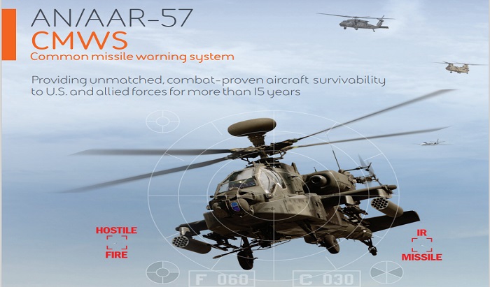
BAE Systems
CMWS Sales Sheet web

View page in English


디렉터리 기능
전시회 도우미
In-depth Exhibitor Profiles
Each exhibitor can add as many products and services as they wish, with in-depth information and specifications. This allows buyers to find what they want easily.
Self Provisioning for Exhibitors
Each exhibitor has full control of their content - to edit their company profile, upload products and enter staff details.
방문 계획 수립
북마크 도구와 이벤트 플래너를 사용해 방문하고자 하는 기업과 관심 있는 제품을 검색하세요. 저장한 모든 항목을 조회할 수 있습니다
고급 검색
고급 검색 기능을 사용하여 상품, 인물, 기업의 위치를 빠르게 조회할 수 있습니다. 최첨단 기술을 통해 모든 참가사의 정보를 철저히 스캔하여 세밀하고 관련성 있는 정보를 제공합니다
상호작용 가능 평면도
디렉터리를 사용해 전시회를 손쉽게 둘러보세요. 방문하고자 하는 기업의 위치와, 행사장 내 식당, 화장실, 출입구를 평면도에서 찾을 수 있습니다.
플랫폼 내 메시지
플랫폼 상의 전시 참가사와 관람객에게 직접 연락하여 미팅을 신청하거나 추가 정보를 요청하세요.
최신 콘텐츠
기업, 상품, 뉴스, 이벤트

BAE Systems
Intelligent Autonomous Systems R&D
Success in modern warfare requires technologies that use adaptive intelligence processing to help military personnel make better decisions faster and stay ahead of opponents at every stage of mission. That's what our Autonomy R&D teams excel at creating, and it's what our unparalleled autonomous solutions deliver on land, at sea, in the air, in space, and beyond.

Integrated Procurement Technologies
CH-47
CH-47 CHINOOK
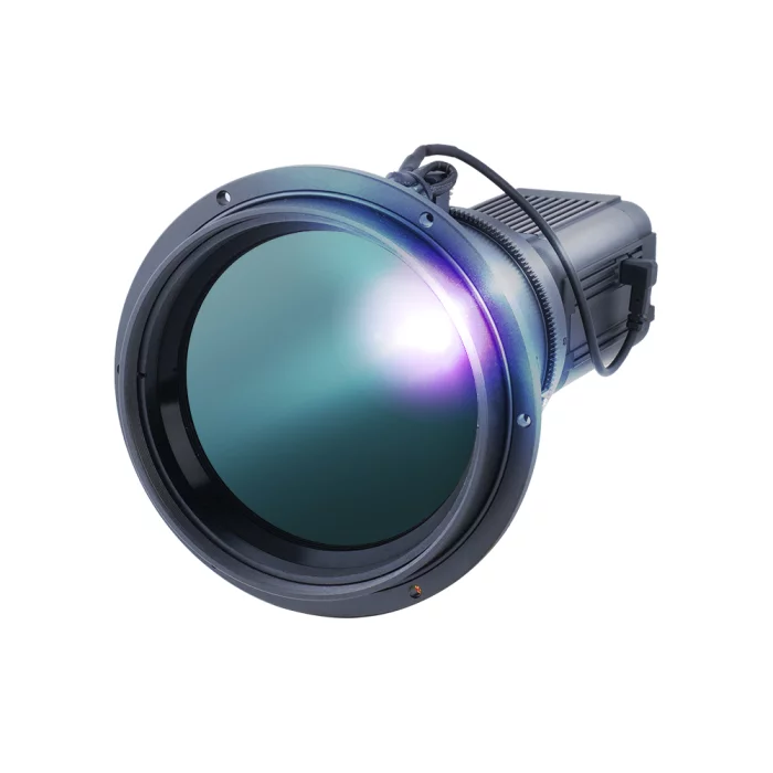
COX
CZ600IP
The CZ600IP is a high-performance un-cooled LWIR thermal camera engineered to deliver professional-grade imaging and system integration. With a 640x480 resolution and 12μm pixel pitch sensor, it provides exceptional clarity and detail, even in low-contrast environments. Its motorized focus and zoom control ensure smooth and accurate long-range observations, making it ideal for applications that demand both precision and flexibility. The camera’s wide temperature measurement range further enhances its utility, supporting reliable operation in industrial process monitoring, facility security, and advanced research projects.
Equipped with modern networking features, the CZ600IP supports Gigabit Ethernet connectivity, H.265/H.264 compression, and OnVif Profile S compliance, ensuring seamless integration with existing surveillance and monitoring systems. It also offers multi-streaming capabilities and advanced security protocols, allowing safe and efficient deployment in critical infrastructure. By combining robust imaging technology with flexible system compatibility, the CZ600IP stands out as a versatile solution that adapts to evolving customer needs while maintaining high reliability and accuracy.
Equipped with modern networking features, the CZ600IP supports Gigabit Ethernet connectivity, H.265/H.264 compression, and OnVif Profile S compliance, ensuring seamless integration with existing surveillance and monitoring systems. It also offers multi-streaming capabilities and advanced security protocols, allowing safe and efficient deployment in critical infrastructure. By combining robust imaging technology with flexible system compatibility, the CZ600IP stands out as a versatile solution that adapts to evolving customer needs while maintaining high reliability and accuracy.
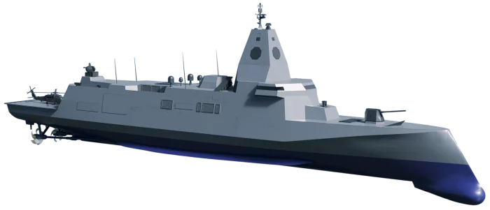
Hanwha Ocean Co., Ltd.
OCEAN-74F
· Next-generation naval combat platform with full-spectrum mission readiness: from naval warfare domains to asymmetric threats
· Integrated manned-unmanned combat system enabled by UAVs, USVs, and UUVs
· Multi-layered defense system with laser weapons and long-range loitering munitions
· Optimized manning for modern warfare through an integration of smart bridge and combat Information Center, automation and unmanned systems