한국어로 페이지 보기
Seoul ADEX 2025 Digital Directory
Plan your trip to Seoul ADEX 2025 using our state of the art Digital Directory
Register in seconds with just your email


Directory Features
To help you at the show
In-depth Exhibitor Profiles
Each exhibitor can add as many products and services as they wish, with in-depth information and specifications. This allows buyers to find what they want easily.
Self Provisioning for Exhibitors
Each exhibitor has full control of their content - to edit their company profile, upload products and enter staff details.
Plan your trip
Use the bookmarking and event planning tool to research the companies you would like to visit and the products you are interested in finding. You will be able to locate all of your saved companies on our floorplan
Advanced Search
Utilize our advanced search function to quickly locate products, people, and companies. Our state-of-the-art technology thoroughly scans all exhibitor information, delivering precise and relevant results
Interactive Floorplan
Navigate the show effortlessly with our directory. Use the floorplan to locate companies you want to visit and to find your way to onsite restaurants, toilets and site entrances and exits.
On-platform Messaging
Reach out to exhibitors and visitors directly on our platform to set up meetings, or request more information.
Some of our latest content
Companies, Products, News, Events
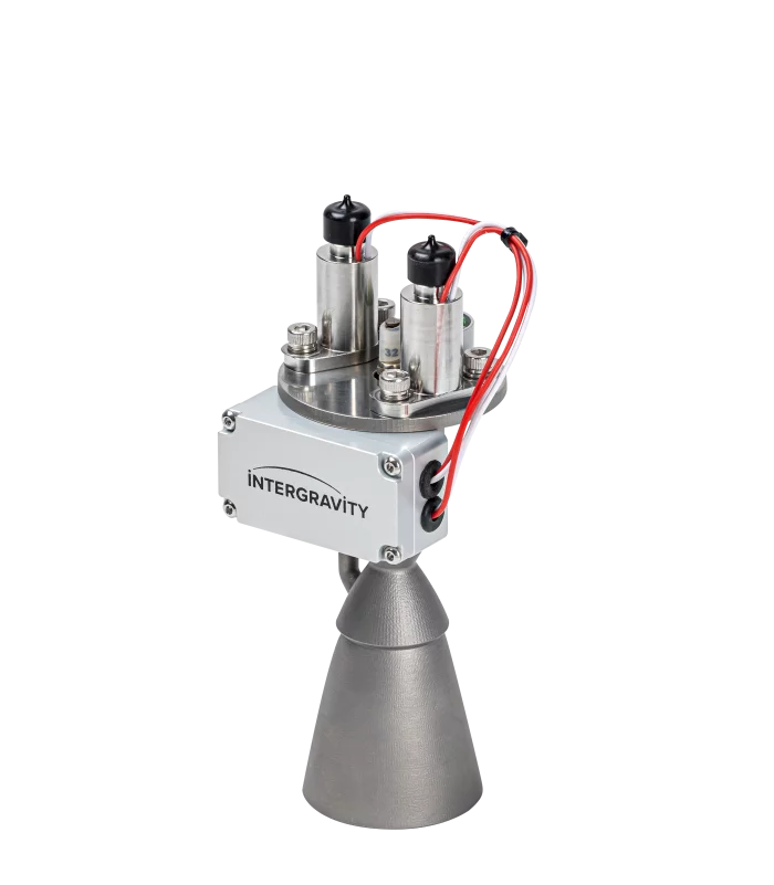
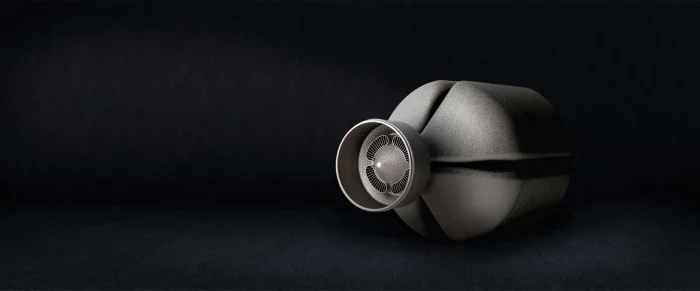
Intergravity Technologies
20N bipropellant thruster
InterGravity Technologies has developed a 20 Newton-class bipropellant thruster designed for orbital transfer vehicles (OTVs), lunar hoppers, and micro-spacecraft requiring high efficiency, reliability, and reusability. The thruster operates with green propellants (C₂H₆, N₂O), providing both environmental compatibility and storability advantages.
Key Features
-Thrust Level : 20N
-Specific Impulse : > 295s in vacuum
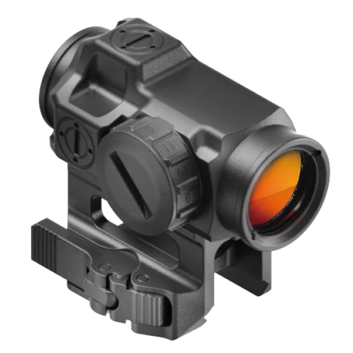
SU Optics
ACTUS® CORE-2 Dot Sight
The ACTUS® CORE-2 Dot Sight is a high-performance optical device chosen as the Warrior Platform Selection Equipment by the Republic of Korea Army (ROKA).
Built to MIL-SPEC standards, it is a further development of our ACTUS® CORE-1 Dot Sight. Housed in a smaller form factor, the ACTUS® CORE-2 meets rigorous military requirements, including extreme temperature resistance, shock testing, waterproofing, and protection against fluid contamination. Designed for durability and reliability, the CORE-2 enhances operator safety in the field, ensuring quick and precise target acquisition during critical missions.
Woori HQ Inc.
Auxiliary Power Unit
Auxiliary generator that can receive separate power without starting the tank
SAFRAN
End-to-end electrical design
Safran Engineering Services offer includes EWIS technology design and certification, electrical requirements management, electrical systems architecture, definition and wiring architecture, components definition (BOM), electrical wire harness assembly, installation design, electrical load analysis, 3D modeling / 2D drawing creation, manufacturing tools (Formboard), work Instruction development and wire harness installation design.

View page in English


디렉터리 기능
전시회 도우미
In-depth Exhibitor Profiles
Each exhibitor can add as many products and services as they wish, with in-depth information and specifications. This allows buyers to find what they want easily.
Self Provisioning for Exhibitors
Each exhibitor has full control of their content - to edit their company profile, upload products and enter staff details.
방문 계획 수립
북마크 도구와 이벤트 플래너를 사용해 방문하고자 하는 기업과 관심 있는 제품을 검색하세요. 저장한 모든 항목을 조회할 수 있습니다
고급 검색
고급 검색 기능을 사용하여 상품, 인물, 기업의 위치를 빠르게 조회할 수 있습니다. 최첨단 기술을 통해 모든 참가사의 정보를 철저히 스캔하여 세밀하고 관련성 있는 정보를 제공합니다
상호작용 가능 평면도
디렉터리를 사용해 전시회를 손쉽게 둘러보세요. 방문하고자 하는 기업의 위치와, 행사장 내 식당, 화장실, 출입구를 평면도에서 찾을 수 있습니다.
플랫폼 내 메시지
플랫폼 상의 전시 참가사와 관람객에게 직접 연락하여 미팅을 신청하거나 추가 정보를 요청하세요.
최신 콘텐츠
기업, 상품, 뉴스, 이벤트
_700.webp)
BIBUS METALS KOREA
AEROSPACE
NILO® Alloy 36
Bars-Sheets and Plates-Tubes and Pipes-Strip-Wire
NILO® Alloy 48
Bars-Strip
INCONEL® Alloy 230
Bars-Sheets and Plates
INCONEL® Alloy 600
Bars-Sheets and Plates-Tubes and Pipes-Wire
INCONEL® Alloy 625
Bars-Sheets and Plates-Tubes and Pipes
INCONEL® Alloy 718
Bars-Sheets and Plates
INCONEL® Alloy X-750
Bars-Sheets and Plates
INCONEL® Alloy HX
Bars-Sheets and Plates-Tubes and Pipes
INCOLOY® Alloy A-286
Bars-Sheets and Plates
NIMONIC® Alloy 75
Bars-Sheets and Plates
NIMONIC® Alloy 80A
Bars-Sheets and Plates
NIMONIC® Alloy 90
Bars-Sheets and Plates-Strip-Wire
NIMONIC® Alloy 263
Sheets and Plates
UDIMET® Alloy 188
Bars-Sheets and Plates
UDIMET® Alloy L-605
Bars-Sheets and Plates
Waspaloy®
Sheets and Plates
Titanium Grade 2
Bars-Sheets and Plates-Tubes and Pipes
Titanium Grade 5 (6Al-4V)
Bars-Sheets and Plates
Material no. 1.4545.4 / 15-5PH
Bars
Material no. 1.4548.4 / 17-4 PH
Bars
Material no. 1.4546.9
Bars
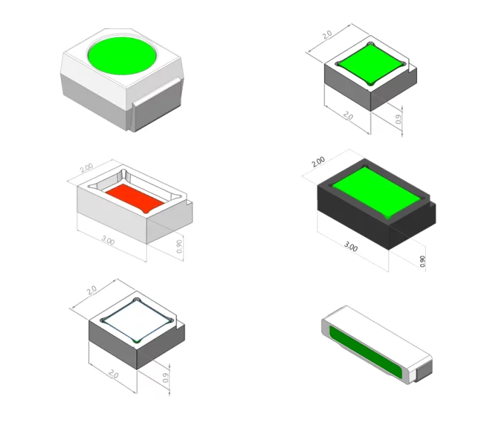
PSIONdsp
NVIS LED
Psion designs and manufactures high-performance NVIS-compatible LEDs, supporting a wide range of applications in defense and aerospace industries. Our lineup includes Green A, Green B, Red, Yellow, Covert, White, as well as white- and black-frame LEDs — all developed to meet MIL-STD-3009 requirements.
We specialize in customized solutions, offering flexible options in wavelength, color, size, and optical characteristics to meet diverse customer specifications. With several years of R&D experience and ongoing deliveries to global clients, Psion is actively shaping the future of the NVIS LED market through innovation and precision engineering.
Conflux Technology
Gas-Gas
Heat Exchange
Additive manufacturing:
- allows highly efficient, compact recuperators with custom flow paths, maximizing energy recovery and reducing overall system emissions.
- charge air coolers enhance cooling performance with tailored airflow designs, reducing intake temperatures and boosting engine efficiency.
- delivers precise, space-efficient pre-coolers and heaters, ensuring optimized thermal response and energy efficiency for various industrial applications.
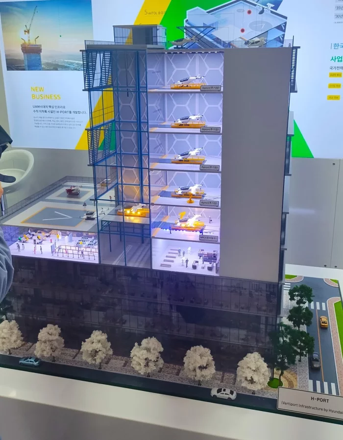
Hyundai Elevator Co., Ltd.
H-PORT / vertical layered vertiport
Hyundai Elevator is leveraging its expertise in elevator technology to develop infrastructure for urban air mobility (UAM). We are working on takeoff, landing, charging, and maintenance platforms that can be built on top of existing buildings, solving space constraints in congested urban environments. Our initiative is backed by their manufacturing expertise and government support, though global building codes may present a challenge in scaling the solution.