한국어로 페이지 보기
Seoul ADEX 2025 Digital Directory
Plan your trip to Seoul ADEX 2025 using our state of the art Digital Directory
Register in seconds with just your email


Directory Features
To help you at the show
In-depth Exhibitor Profiles
Each exhibitor can add as many products and services as they wish, with in-depth information and specifications. This allows buyers to find what they want easily.
Self Provisioning for Exhibitors
Each exhibitor has full control of their content - to edit their company profile, upload products and enter staff details.
Plan your trip
Use the bookmarking and event planning tool to research the companies you would like to visit and the products you are interested in finding. You will be able to locate all of your saved companies on our floorplan
Advanced Search
Utilize our advanced search function to quickly locate products, people, and companies. Our state-of-the-art technology thoroughly scans all exhibitor information, delivering precise and relevant results
Interactive Floorplan
Navigate the show effortlessly with our directory. Use the floorplan to locate companies you want to visit and to find your way to onsite restaurants, toilets and site entrances and exits.
On-platform Messaging
Reach out to exhibitors and visitors directly on our platform to set up meetings, or request more information.
Some of our latest content
Companies, Products, News, Events
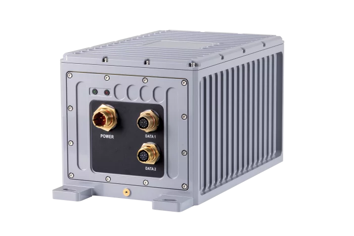
FIBERPRO, Inc
Inertial Navigation System for Gyrocompass
- FOG based Inertial Navigation System for Gyrocompass
- Position Accuracy(INS/GPS): < 3 m
- Heading Accuracy: < 0.1º sec (LAT)
- Attitude Accuracy(Static): 0.01º
- Attitude Accuracy(Dynamic): 0.01º
- Operating Voltage: 9 to 36 VDC
- Power Consumption: < 15 W (typ.)
- Dimension(L x W x H): 330 mm x 192mm x 180mm

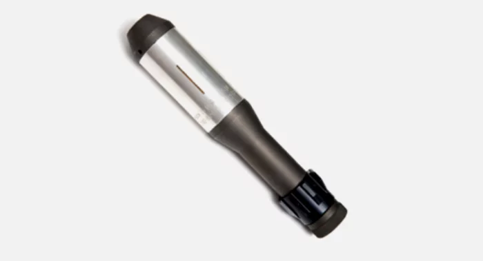
hitecrcd Korea
SG15BL-CAN-12V-CIRCULAR-CONN
With an operating voltage of 9~15 volts, the rugged SG15BL is designed with a high-performance brushless motor, magnetic encoder, and durable, hardened steel gears. It includes CAN 2.0 A/B or DroneCAN (formerly UAVCAN) control options with 360 degrees and multi-turn proportional rotation. With smooth and decisive movement and accuracy along with a true waterproof rating, this aluminum case 15mm micro servo is designed for industrial applications requiring maximum performance in tight spaces.
#UAV #UAS #UGV #UUV #USV
DASAN MACHINERIES CO., LTD
SABOT TRAINER 60MM
Material: SS400-540, SPPS and ALDC1-8
Application Equipment: 60mm Mortar
Purpose: Training for Prectice
_700.webp)
A-Tech Aviation
Engine Parts, Overhaul
Engine Parts, Overhaul

View page in English


디렉터리 기능
전시회 도우미
In-depth Exhibitor Profiles
Each exhibitor can add as many products and services as they wish, with in-depth information and specifications. This allows buyers to find what they want easily.
Self Provisioning for Exhibitors
Each exhibitor has full control of their content - to edit their company profile, upload products and enter staff details.
방문 계획 수립
북마크 도구와 이벤트 플래너를 사용해 방문하고자 하는 기업과 관심 있는 제품을 검색하세요. 저장한 모든 항목을 조회할 수 있습니다
고급 검색
고급 검색 기능을 사용하여 상품, 인물, 기업의 위치를 빠르게 조회할 수 있습니다. 최첨단 기술을 통해 모든 참가사의 정보를 철저히 스캔하여 세밀하고 관련성 있는 정보를 제공합니다
상호작용 가능 평면도
디렉터리를 사용해 전시회를 손쉽게 둘러보세요. 방문하고자 하는 기업의 위치와, 행사장 내 식당, 화장실, 출입구를 평면도에서 찾을 수 있습니다.
플랫폼 내 메시지
플랫폼 상의 전시 참가사와 관람객에게 직접 연락하여 미팅을 신청하거나 추가 정보를 요청하세요.
최신 콘텐츠
기업, 상품, 뉴스, 이벤트
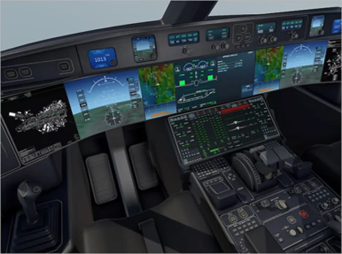
Ansys_Korea
Avionics and Flight Control Systems
In high-reliability industries such as aerospace, defense, and nuclear, embedded software is emerging as a core competitive advantage, driving increasing demand for systems based on safety certification.
Ansys SCADE is a model-based solution that supports the entire lifecycle of safety-critical software—from design to certification—for applications such as flight control systems, engine controllers, and cockpit display systems (CDS). It ensures high reliability, real-time performance, and safety compliance required for the development of complex avionics systems.
Key Features
- Model-based embedded software development and automatic code generation
- Compliance with aerospace safety certification standards such as DO-178C, ARINC 661, and FACE™
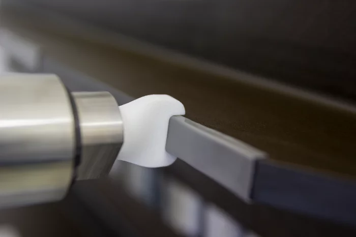
ViscoTec Pumpen- u. Dosiertechnik GmbH
Edge Sealing for Structural Components
Wing shells, side shells and fuselage sections are usually made of carbon fibre composites and glued together during the production process. With many components, a groove or an open edge remains after the bonding process, which must be filled or sealed.
A modified two-component epoxy resin is often mixed and then applied manually. This often entails long production times and complex quality controls. Equally high material costs due to the processing of materials from cartridges.
ViscoTec defies short pot life and materials that are difficult to handle: Thanks to a coherent overall system from material removal to material application, this process can be automated. The two components are taken separately from cartridges, hobbocks or drums and fed via hose lines to a two-component dosing system. Only at the very end of the process they are mixed in a static mixing tube and applied to the substrate (e.g. via a nozzle). The process is controlled and monitored by pressure sensors.
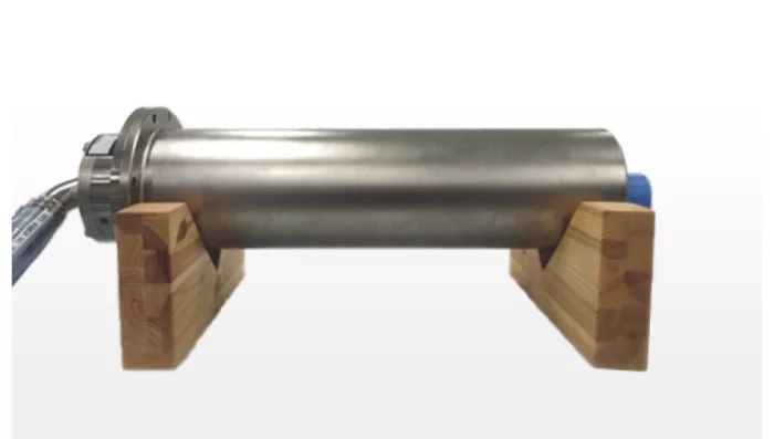
ROTAC
Sonar Winch
FINISHED THE DEVELOPING / INTEGRATED THE 2CH. FORJ
Specification
MODEL: SREM-1466-012
APPLICATION: SONAR WINCH
SIZE: Φ140(O.D) / 664(H)
NO. OF RINGS: 128RINGS
TYPE: END
ROTATING: CW/CCW
_700.webp)
EUCAST
EPNR1000 - Drone mounted 5G System (Network in a Box)
The EPNR1000 is a drone-mounted 5G base station integrating CU-DU-RU, with 5G Core and an IP-PTT application server built in. All 5G network elements are combined into a single unit, allowing standalone operation (IOPS). Mounted on a drone, it can provide line-of-sight coverage over obstacles like buildings or mountains, making it an ideal system for delivering 5G services over wide areas during disasters or military operations.