한국어로 페이지 보기
Seoul ADEX 2025 Digital Directory
Plan your trip to Seoul ADEX 2025 using our state of the art Digital Directory
Register in seconds with just your email


Directory Features
To help you at the show
In-depth Exhibitor Profiles
Each exhibitor can add as many products and services as they wish, with in-depth information and specifications. This allows buyers to find what they want easily.
Self Provisioning for Exhibitors
Each exhibitor has full control of their content - to edit their company profile, upload products and enter staff details.
Plan your trip
Use the bookmarking and event planning tool to research the companies you would like to visit and the products you are interested in finding. You will be able to locate all of your saved companies on our floorplan
Advanced Search
Utilize our advanced search function to quickly locate products, people, and companies. Our state-of-the-art technology thoroughly scans all exhibitor information, delivering precise and relevant results
Interactive Floorplan
Navigate the show effortlessly with our directory. Use the floorplan to locate companies you want to visit and to find your way to onsite restaurants, toilets and site entrances and exits.
On-platform Messaging
Reach out to exhibitors and visitors directly on our platform to set up meetings, or request more information.
Some of our latest content
Companies, Products, News, Events
Canister UAV Launcher ISO(Unfolding)_230110-72 - 복사본_700.webp)
FINE KOWAC Co., Ltd.
Canister Launched UAV_CHANGER 7
It is a system that performs missions such as monitoring, surveillance and reconnaissance by ejecting and launching a foldable fixed-wing drone from the canister(tube) launcher.
It is equipped with EO/IR Cameras (Electro-Optical / Infra-Red), which are mission equipment for reconnaissance, so that effective day and night image information can be collected. The gathered image information is transmitted to the ground control system (GCS) in real time while detecting and tracking the target by applying AI-based image processing technology.
The foldable fixed-wing UAV has a simple structure and light weight, so it can be stored and transported in the canister launcher, and can be operated immediately so that it can be operated without time delay, and if necessary, the air vehicle can be retrieved and re-used by using a net-type recovery system.
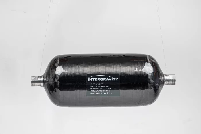
Intergravity Technologies
Type-III Composite Pressure Vessel
InterGravity Technologies has developed a Type-III Composite Overwrapped Pressure Vessel (COPV) optimized for high-performance small spacecraft propulsion systems. The tank is designed with an aluminum alloy liner for impermeability and a carbon fiber/epoxy composite overwrap for high strength-to-weight ratio. The system is tailored for green propellant storage (C₂H₆, N₂O), offering an exceptionally lightweight yet robust solution for orbital transfer vehicles and CubeSat-class platforms.
Technical Specifications
- Type : Type-III COPV (Al liner + CFRP wrap)
- Volume : 5.3 liters
- MEOP : 75 bar
- Proof : 230 bar
- Burst : 250 bar
- Dry Mass : < 1.0 kg

Wedps
전원발생장치(Generator)
1. 용도 : 차량의 엔진동력을 이용하여 요구하는 전력을 생성하는 장치
2. 기능 : 정격출력 10kW, 3상 140V~560V 생성
3. 관련 장비/체계 분야 : 30밀리 자주대공포(비호복합), 단거리지대공무기(천마)
4. 관심 협업 분야 / 목표시장(국가)
- 전차ㆍ장갑차 그 밖의 전투기동장비 / 국내 방위산업시장 및 해외
(미국, 멕시코, 프랑스, 이스라엘, 인도네시아, 말레이시아, 아랍에미리트, 유엔국 등)
5. 기타사항
- 영구자석 기반 발전기 기술 및 고효율 에너지변환 기술(특허보유)
- 국방규격화 완료, 해외수출 경쟁력 제품
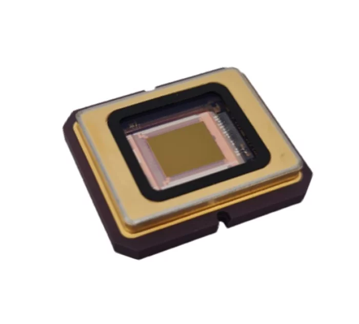
SCD - Semi Conductor Devices
SWIFT-EI
The SWIFT-EI is the world’s first SWIR detector to feature a state-of-the-art read-out integrated circuit (ROIC), enabling low size, weight, power, and cost (SWaP-C). It supports VGA image format for SWIR imaging, multi-spot ALPD (asynchronous laser pulse detection), and a rapid imaging frame rate of up to 1,600 frames per second.
The revolutionary ROIC introduces an independent neuromorphic imaging stream for event detection, which greatly expands capabilities in target detection and classification.
Ideal for cutting-edge, low SWaP-C applications, the SWIFT-EI can be integrated into a variety of air platforms, missiles, vehicles, and handheld devices, making it extraordinarily versatile. With SWIFT-EI, SCD’s customers always have the advantage of being the FIRST TO SEE.

View page in English


디렉터리 기능
전시회 도우미
In-depth Exhibitor Profiles
Each exhibitor can add as many products and services as they wish, with in-depth information and specifications. This allows buyers to find what they want easily.
Self Provisioning for Exhibitors
Each exhibitor has full control of their content - to edit their company profile, upload products and enter staff details.
방문 계획 수립
북마크 도구와 이벤트 플래너를 사용해 방문하고자 하는 기업과 관심 있는 제품을 검색하세요. 저장한 모든 항목을 조회할 수 있습니다
고급 검색
고급 검색 기능을 사용하여 상품, 인물, 기업의 위치를 빠르게 조회할 수 있습니다. 최첨단 기술을 통해 모든 참가사의 정보를 철저히 스캔하여 세밀하고 관련성 있는 정보를 제공합니다
상호작용 가능 평면도
디렉터리를 사용해 전시회를 손쉽게 둘러보세요. 방문하고자 하는 기업의 위치와, 행사장 내 식당, 화장실, 출입구를 평면도에서 찾을 수 있습니다.
플랫폼 내 메시지
플랫폼 상의 전시 참가사와 관람객에게 직접 연락하여 미팅을 신청하거나 추가 정보를 요청하세요.
최신 콘텐츠
기업, 상품, 뉴스, 이벤트
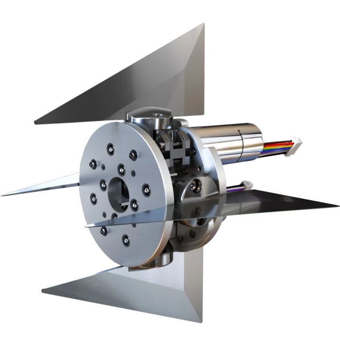
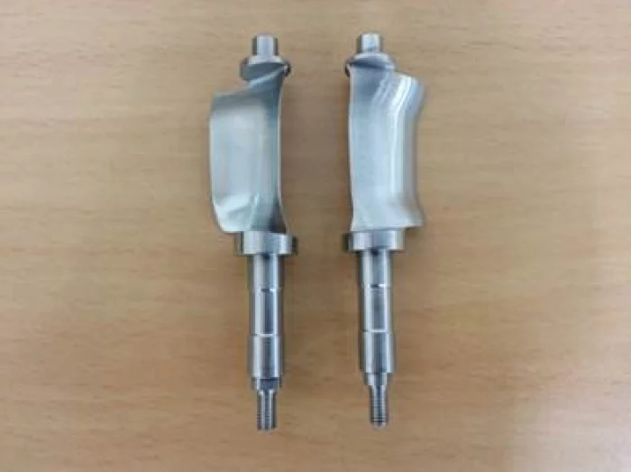
MPS bearings Co., Ltd.
Control Actuation System (CAS)
This Control Actuation System (CAS) is a guidance system for unmanned flying objects. It consists of three MPS fin actuators that each independently position an aerodynamic fin. The maximum angle of incidence is ±8°, which allows the device to carry out highly precise dynamic manoeuvres.
The miniature fin actuators that make up this Control Actuation System are manufactured by MPS Microsystems and were designed based on customer specifications. Designed to guide a very small object and disposing of an extremely limited space, these fin actuators meet strict requirements in terms of performance, weight - less than 100 g - and dimensions. To reduce the length of this actuator, MPS Microsystems used part of the screw length as the motor axis. This screw is equipped with a very compact 4-point contact bearing that simultaneously absorbs axial and radial loads. The angular play on the aileron axis is less than 0.1° rms. This actuator meets the storage and vibration requirements of military equipment.
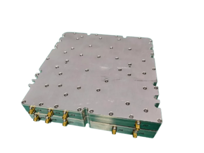
Eltronix Co., Inc
L-band 8CH Filter-BANK RX Module
The L-band 8-channel filter bank receiver module is equipped with eight internal filter bank channels, enabling improved reception performance by isolating specific sub-bands within the receive frequency range.
A 100W limiter at the input stage protects the receiver from high-power signals, and the module offers a low noise figure of 3.0 dB or less.
The input P1dB for the receiver is -20 dBm, and the module features a built-in path self-test function.
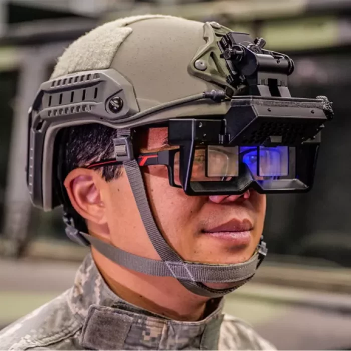
Honeywell Aerospace Technologies
Honeywell 360 Display
Honeywell 360 Display for Aviation
The aviation version of the display is a wearable visor that uses augmented reality to provide civilian or military pilots with a high-resolution 360-degree view that seamlessly matches the view outside the cockpit. It also provides traffic callouts and flight instrumentation in the pilot’s field of view, which makes the Honeywell 360 Display ideal for flying at night, in bad weather or in congested airspace. The display improves safety, pilot confidence and aircraft utility.
Honeywell 360 Display for Rugged Ground Vehicles
Operators of ruggedized vehicles can use the display to safely maneuver in low visibility or hazardous conditions. It improves overall situational awareness, reaction speed and survivability by increasing visibility and reducing the need to consult instruments in the vehicle. The lightweight head-worn display uses real-time outside high-resolution camera feeds to create a seamless mixed-reality view and provides operators sensor information within their immediate field of view.
JINYOUNG TBX CO.,LTD
VSV
Adjustable stator vanes that control airflow angle entering the rotor blades.