한국어로 페이지 보기
Seoul ADEX 2025 Digital Directory
Plan your trip to Seoul ADEX 2025 using our state of the art Digital Directory
Register in seconds with just your email


Directory Features
To help you at the show
In-depth Exhibitor Profiles
Each exhibitor can add as many products and services as they wish, with in-depth information and specifications. This allows buyers to find what they want easily.
Self Provisioning for Exhibitors
Each exhibitor has full control of their content - to edit their company profile, upload products and enter staff details.
Plan your trip
Use the bookmarking and event planning tool to research the companies you would like to visit and the products you are interested in finding. You will be able to locate all of your saved companies on our floorplan
Advanced Search
Utilize our advanced search function to quickly locate products, people, and companies. Our state-of-the-art technology thoroughly scans all exhibitor information, delivering precise and relevant results
Interactive Floorplan
Navigate the show effortlessly with our directory. Use the floorplan to locate companies you want to visit and to find your way to onsite restaurants, toilets and site entrances and exits.
On-platform Messaging
Reach out to exhibitors and visitors directly on our platform to set up meetings, or request more information.
Some of our latest content
Companies, Products, News, Events
ZYX Technology
DIVE
DIVE (Digital Interactive Virtual Environment) is a GIS-based smart construction management platform jointly developed by ZYX Technology and Korea Expressway Corporation. Designed to meet the growing demand for intelligent infrastructure solutions, DIVE provides real-time integration, monitoring, and analysis of all location-based construction data.
By consolidating diverse sources such as design drawings, land maps, aerial imagery, BIM data, drone footage, and CCTV into a single platform, DIVE enables comprehensive, on-site visibility and control. From large-scale infrastructure to complex tunnel projects, all key information can be accessed and compared in real time, allowing for smarter, faster, and more accurate decision-making.
The main dashboard provides a live overview of each project site, including tasks, equipment, workers, events, and safety issues. With its daily work management feature, site managers can view exact personnel and equipment allocations for each zone, improving efficiency and minimizing risk.
DIVE also supports seamless integration with tunnel monitoring systems, offering real-time access to excavation status, geotechnical sensors, and worker presence inside the tunnel. This ensures enhanced safety and process transparency in high-risk environments.
Drone integration further strengthens site management by providing up-to-date aerial visuals, reducing blind spots and enabling rapid response to field changes. In addition, the platform links design drawings with cadastral maps to streamline permitting, track construction progress, and manage change orders with geographic accuracy.
Whether you're building roads, tunnels, or complex infrastructure, DIVE empowers construction teams with a powerful digital environment to manage the entire project lifecycle.
Canister UAV Launcher ISO(Unfolding)_230110-72 - 복사본_700.webp)
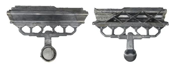
FINE KOWAC Co., Ltd.
Canister Launched UAV_CHANGER 7
It is a system that performs missions such as monitoring, surveillance and reconnaissance by ejecting and launching a foldable fixed-wing drone from the canister(tube) launcher.
It is equipped with EO/IR Cameras (Electro-Optical / Infra-Red), which are mission equipment for reconnaissance, so that effective day and night image information can be collected. The gathered image information is transmitted to the ground control system (GCS) in real time while detecting and tracking the target by applying AI-based image processing technology.
The foldable fixed-wing UAV has a simple structure and light weight, so it can be stored and transported in the canister launcher, and can be operated immediately so that it can be operated without time delay, and if necessary, the air vehicle can be retrieved and re-used by using a net-type recovery system.
_700.webp)
TelePIX Co., Ltd.
Chouette
A Very High Resolution (0.75 m GSD) and Wide-Field of View (24 km swath) optical payload under development. Designed for microsatellite integration, Chouette combines sub-meter detail with wide-area coverage, a unique balance that expands the scope of commercial EO applications beyond what current systems offer.
 (1)_700.webp)
FIBERPRO, Inc
Dual-band 4-element Anti-jamming system
• Band Width : L1/L5 or L1/L2
• Supported GNSS Constellations : GPS/Galileo/NavIC/GLONASS/BeiDou
• Interference resistance :
- Single jammer interference resistance up to 90 dB(J/S)
- Multiple jammers interference resistance up to 82 dB(J/S)
- Support of up to 3 jammers simultaneously for each of
frequency bands
• Interfaces : Digital output
• Power Consumption : Low power consumption

View page in English


디렉터리 기능
전시회 도우미
In-depth Exhibitor Profiles
Each exhibitor can add as many products and services as they wish, with in-depth information and specifications. This allows buyers to find what they want easily.
Self Provisioning for Exhibitors
Each exhibitor has full control of their content - to edit their company profile, upload products and enter staff details.
방문 계획 수립
북마크 도구와 이벤트 플래너를 사용해 방문하고자 하는 기업과 관심 있는 제품을 검색하세요. 저장한 모든 항목을 조회할 수 있습니다
고급 검색
고급 검색 기능을 사용하여 상품, 인물, 기업의 위치를 빠르게 조회할 수 있습니다. 최첨단 기술을 통해 모든 참가사의 정보를 철저히 스캔하여 세밀하고 관련성 있는 정보를 제공합니다
상호작용 가능 평면도
디렉터리를 사용해 전시회를 손쉽게 둘러보세요. 방문하고자 하는 기업의 위치와, 행사장 내 식당, 화장실, 출입구를 평면도에서 찾을 수 있습니다.
플랫폼 내 메시지
플랫폼 상의 전시 참가사와 관람객에게 직접 연락하여 미팅을 신청하거나 추가 정보를 요청하세요.
최신 콘텐츠
기업, 상품, 뉴스, 이벤트
SAMKEE ENERGY SOLUTIONS
Alu-Carbon Fiber
High design freedom of aluminum die casting and excellent mechanical properties of carbon fiber can be combined to replace high-tensile steel.
.jpg)
ABC Essais
Services - ABC Essais
Maintenance Increase security and productivity to reduce costs and minimize downtime. Willing to provide our customers with high-performance technical assistance, we offer scheduled and unplanned maintenance interventions, as well as periodic verification of measurement channels using our calibration equipments. Our systems allow us to perform these operations internally or at our customers site.
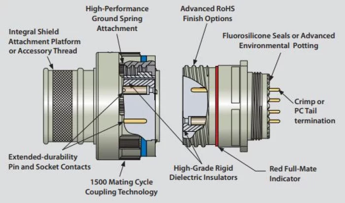
Glenair
SuperNine®
The Series 23 SuperNine® advanced performance MIL-DTL-38999 connector series provides many of the technology advances exceeding MIL-DTL-38999 Series III. Higher mating cycles, integrated banding porch, PC Tail and standoff availability and crimp termination Hermetics are all part of the family.
_700.webp)
GEOSTORY Co., Ltd
Pseudo-GNSS
The Pseudo-GNSS system is designed with tightly integrated firmware and hardware.
The firmware generates PRN signals based on GNSS orbital data, modulates them to resemble real GNSS signals, and ensures time synchronization in a Master-Slave structure. A user-friendly GUI software enables easy device control.
The hardware consists of a power unit, signal transmission unit, and communication unit. The power unit ensures stable supply through low-noise design, while the transmission unit radiates GNSS-like signals indoors. The communication unit supports Wi-Fi and wired connections for synchronization and control across multiple devices, with compatibility for smartphones and tablets to display positioning results.