한국어로 페이지 보기
Seoul ADEX 2025 Digital Directory
Plan your trip to Seoul ADEX 2025 using our state of the art Digital Directory
Register in seconds with just your email


Directory Features
To help you at the show
In-depth Exhibitor Profiles
Each exhibitor can add as many products and services as they wish, with in-depth information and specifications. This allows buyers to find what they want easily.
Self Provisioning for Exhibitors
Each exhibitor has full control of their content - to edit their company profile, upload products and enter staff details.
Plan your trip
Use the bookmarking and event planning tool to research the companies you would like to visit and the products you are interested in finding. You will be able to locate all of your saved companies on our floorplan
Advanced Search
Utilize our advanced search function to quickly locate products, people, and companies. Our state-of-the-art technology thoroughly scans all exhibitor information, delivering precise and relevant results
Interactive Floorplan
Navigate the show effortlessly with our directory. Use the floorplan to locate companies you want to visit and to find your way to onsite restaurants, toilets and site entrances and exits.
On-platform Messaging
Reach out to exhibitors and visitors directly on our platform to set up meetings, or request more information.
Some of our latest content
Companies, Products, News, Events
_700.webp)
ANH Structure
Composite Propellant Tank
- Reduced weight and manufacturing cost by more than 30% compared to conventional metallic propellant tanks
- Designed and qualified to according KARI requirements
- Proof & burst pressure application
- Cyclic pressure(MEOP, Max. Enveloped Operating Pressure) application, more than 40 cycles
Danam Systems Inc.
Compact Telemetry Transmitter
ㅇKey Features
- User Configurable or Factory Set equipment
- Support Single/Multi-Band Configuration
- Compact / Low Weight / High Power Efficiency
- Clock-Free Input Option Available
- RS-422 (DATA±, CLK±), RS-232(DEBUG)
ㅇQuality and Certification
- IRIG 106
- MIL-STD-810G
Ultronics
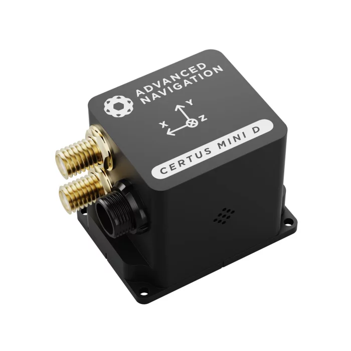
Certus Mini D
AI Navigation Algorithm
The Certus Mini range features Advanced Navigation’s revolutionary AI neural network sensor fusion algorithm.
The algorithm was designed for control applications and has a high level of health monitoring and instability prevention to ensure stable and reliable data.
High-Performance MEMS
The Certus Mini range contains high performance MEMS sensors that are put through Advanced Navigation’s intensive 8 hour temperature calibration process.
This provides the highest accuracy possible from this sensor class and outputs consistent accuracy over the full temperature range from -40°C to 85°C.
Reliability
The Certus Mini range has been designed from the ground up for mission-critical control applications where reliability is essential.
Built using a safety-oriented real-time operating system, all software is designed and tested to high safety standards with fault-tolerance in mind.
The Certus Mini range is designed, manufactured and tested to military standards.
L1/L5 Multi Constellation RTK GNSS
The Certus Mini D supports L1/L5 dual frequencies, and GPS, GLONASS, Galileo, BeiDou and NavIC constellations.
Access to multiple constellations and frequencies provides enhanced accuracy, availability and performance even in difficult environments such as multi-storey urban canyons.
The GNSS receiver has 10 mm position accuracy with real-time RTK or post-processed PPK.
Dual Antenna Heading
The Certus Mini D provides a high accuracy heading solution using two GNSS antennas. The Certus Mini D rapidly and consistently maintains an accurate heading without the need for magnetic calibration and is unaffected by magnetic interference.
Additionally, the system can determine heading while stationary. This makes it well-suited to applications where there is limited, or no, positional movement.
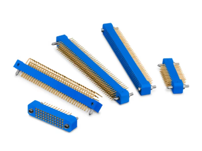
Sangdo Electronics co.,Ltd
KA Series
High reliability KA series MIL-DTL-55302 compliant connectors offer signal contacts designed for demanding defense, commercial aerospace and space applications. The 2 and 3 row series are compliant to MIL-DTL-55302 and offer flexibility not available with other interconnects. The 4 and 5 row versions are also available and offer up to 490 contacts.

View page in English


디렉터리 기능
전시회 도우미
In-depth Exhibitor Profiles
Each exhibitor can add as many products and services as they wish, with in-depth information and specifications. This allows buyers to find what they want easily.
Self Provisioning for Exhibitors
Each exhibitor has full control of their content - to edit their company profile, upload products and enter staff details.
방문 계획 수립
북마크 도구와 이벤트 플래너를 사용해 방문하고자 하는 기업과 관심 있는 제품을 검색하세요. 저장한 모든 항목을 조회할 수 있습니다
고급 검색
고급 검색 기능을 사용하여 상품, 인물, 기업의 위치를 빠르게 조회할 수 있습니다. 최첨단 기술을 통해 모든 참가사의 정보를 철저히 스캔하여 세밀하고 관련성 있는 정보를 제공합니다
상호작용 가능 평면도
디렉터리를 사용해 전시회를 손쉽게 둘러보세요. 방문하고자 하는 기업의 위치와, 행사장 내 식당, 화장실, 출입구를 평면도에서 찾을 수 있습니다.
플랫폼 내 메시지
플랫폼 상의 전시 참가사와 관람객에게 직접 연락하여 미팅을 신청하거나 추가 정보를 요청하세요.
최신 콘텐츠
기업, 상품, 뉴스, 이벤트
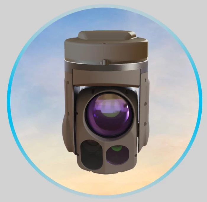
Green Optics Co., Ltd.
MS60
It is a product produced in Korea and has high performance when used in EO/IR Gimbal for small drones.
It can view both VIS and IR images simultaneously and is coupled to a small drone with a small weight to perform operations. Products with manufactured and domestic IR sensors in Korea.
we deliver superior technologies that shape the future of defense. Whether supporting ISR missions or enhancing precision in loitering munition operations, MS60 products are designed to ensure operational excellence in the most challenging environments.
_700.webp)
BIBUS METALS KOREA
AEROSPACE
NILO® Alloy 36
Bars-Sheets and Plates-Tubes and Pipes-Strip-Wire
NILO® Alloy 48
Bars-Strip
INCONEL® Alloy 230
Bars-Sheets and Plates
INCONEL® Alloy 600
Bars-Sheets and Plates-Tubes and Pipes-Wire
INCONEL® Alloy 625
Bars-Sheets and Plates-Tubes and Pipes
INCONEL® Alloy 718
Bars-Sheets and Plates
INCONEL® Alloy X-750
Bars-Sheets and Plates
INCONEL® Alloy HX
Bars-Sheets and Plates-Tubes and Pipes
INCOLOY® Alloy A-286
Bars-Sheets and Plates
NIMONIC® Alloy 75
Bars-Sheets and Plates
NIMONIC® Alloy 80A
Bars-Sheets and Plates
NIMONIC® Alloy 90
Bars-Sheets and Plates-Strip-Wire
NIMONIC® Alloy 263
Sheets and Plates
UDIMET® Alloy 188
Bars-Sheets and Plates
UDIMET® Alloy L-605
Bars-Sheets and Plates
Waspaloy®
Sheets and Plates
Titanium Grade 2
Bars-Sheets and Plates-Tubes and Pipes
Titanium Grade 5 (6Al-4V)
Bars-Sheets and Plates
Material no. 1.4545.4 / 15-5PH
Bars
Material no. 1.4548.4 / 17-4 PH
Bars
Material no. 1.4546.9
Bars
_700.webp)
Invictum
Pulse-80
The Pulse-80 is a premium tactical-grade MEMS IMU, engineered for applications demanding compact size and minimal weight without any compromise on performance.
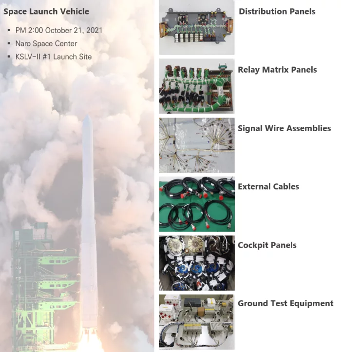
CAPHMICRO Inc.
Wireharness
CAPHMICRO has the ability to design and manufacture wire harnesses and cable assemblies for defense, aerospace, and space launch vehicles/satellites. We design and manufacture in compliance with IPC-620 and J-STD-001 standards. Additionally, we have a global supply chain capable of quickly supplying a wide range of materials. We provide comprehensive solutions for wire harnesses, from design through to manufacturing and inspection.