한국어로 페이지 보기
Seoul ADEX 2025 Digital Directory
Plan your trip to Seoul ADEX 2025 using our state of the art Digital Directory
Register in seconds with just your email


Directory Features
To help you at the show
In-depth Exhibitor Profiles
Each exhibitor can add as many products and services as they wish, with in-depth information and specifications. This allows buyers to find what they want easily.
Self Provisioning for Exhibitors
Each exhibitor has full control of their content - to edit their company profile, upload products and enter staff details.
Plan your trip
Use the bookmarking and event planning tool to research the companies you would like to visit and the products you are interested in finding. You will be able to locate all of your saved companies on our floorplan
Advanced Search
Utilize our advanced search function to quickly locate products, people, and companies. Our state-of-the-art technology thoroughly scans all exhibitor information, delivering precise and relevant results
Interactive Floorplan
Navigate the show effortlessly with our directory. Use the floorplan to locate companies you want to visit and to find your way to onsite restaurants, toilets and site entrances and exits.
On-platform Messaging
Reach out to exhibitors and visitors directly on our platform to set up meetings, or request more information.
Some of our latest content
Companies, Products, News, Events
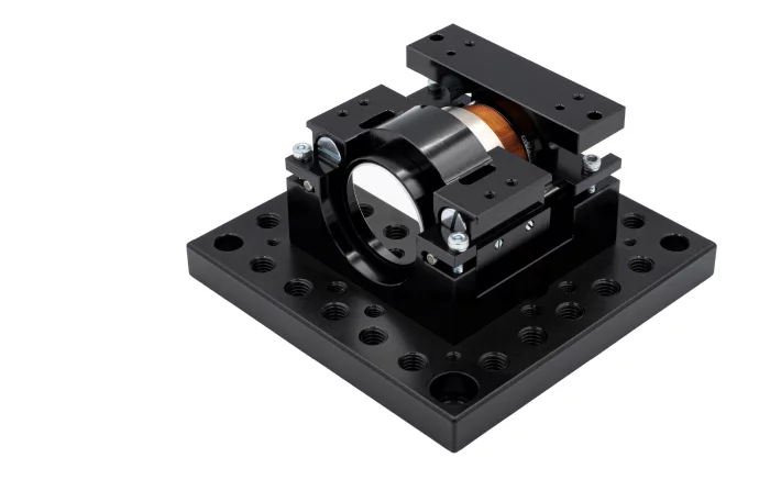
MPS bearings Co., Ltd.
High-Dynamics Voice-Coil Nano-Positioner
Developed by MPS Microsystems, the voice-coil nano-positioner unites a Lorentz-force motor, flexure guidance and on-board electronics inside a 65 × 60 × 38 mm envelope. Standard travel is 2.88 mm, extendable to 7 mm with the same coil, suiting microscope objectives, small mirrors and sensors that demand friction-free motion.
Bidirectional repeatability stays within ±1 µm over a 360 µm stroke and ±2.5 µm across the full stroke. We can tailor mounting plates, objective clamps and cable exits to suit your specific requirements, ensuring that this voice-voil actuator can be integrated seamlessly into your system.
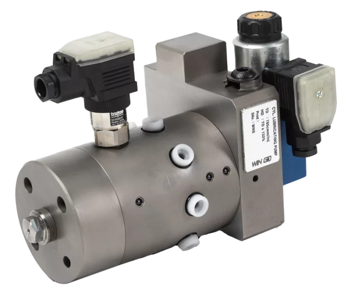
HANMI HYDRAULIC MACHINERY CO., LTD.
Cylinder Lubricating Pump - WIN GD
This system product is a product that directly supplies and heats lubricant oil for smooth operation of the main engine cylinder’s metallic and mechanical movement.
Lubricator, a product that supplies lubrication directly to the main engine cylinder liner, can control injection timing and consumption using an electronic control method that responds to the movement of the main engine piston. The alpha lubricator system is based on an algorithm controlling the cylinder oil dosage proportionally to the sulphur content in the fuel and, fuel consumption on particular load of engine. Minimum cylinder oil dosage is required to provide an adequate oil film and detergency properties.
Everllence and WIN GD engines are currently applying the second generation Lubricator type, the Everllence type is Mk-I and the WIN GD type is Mk-ε (Epsilon).
_700.webp)
Israel Aerospace Industries (IAI)
Mission Aircraft
- Ultimate Situational Awareness capabilities
- Indication & warning of hostile activities
- Designed for the modern battlefield challenges
- Targeting
- Homeland security and border protection
PEI-Genesis
Sensors and Controls

View page in English


디렉터리 기능
전시회 도우미
In-depth Exhibitor Profiles
Each exhibitor can add as many products and services as they wish, with in-depth information and specifications. This allows buyers to find what they want easily.
Self Provisioning for Exhibitors
Each exhibitor has full control of their content - to edit their company profile, upload products and enter staff details.
방문 계획 수립
북마크 도구와 이벤트 플래너를 사용해 방문하고자 하는 기업과 관심 있는 제품을 검색하세요. 저장한 모든 항목을 조회할 수 있습니다
고급 검색
고급 검색 기능을 사용하여 상품, 인물, 기업의 위치를 빠르게 조회할 수 있습니다. 최첨단 기술을 통해 모든 참가사의 정보를 철저히 스캔하여 세밀하고 관련성 있는 정보를 제공합니다
상호작용 가능 평면도
디렉터리를 사용해 전시회를 손쉽게 둘러보세요. 방문하고자 하는 기업의 위치와, 행사장 내 식당, 화장실, 출입구를 평면도에서 찾을 수 있습니다.
플랫폼 내 메시지
플랫폼 상의 전시 참가사와 관람객에게 직접 연락하여 미팅을 신청하거나 추가 정보를 요청하세요.
최신 콘텐츠
기업, 상품, 뉴스, 이벤트

Marvin Test Solutions
Aerospace Test Systems
GENASYS Ultra high-performance mixed signal test platforms deliver a no compromise functional test solution for satellite, airborne electronics, and other mission critical applications. The scalable architecture supports up to 4500 "any resource to any pin" interface test points and features best-in-class digital performance, with preconfigured Benchtop solutions addressing a broad spectrum of lower channel density applications.

STX Engine
Military Diesel Engine
We, STX Engine, started with our business to be designated as a defense company in 1977 and established a factory for defense purposes in 1988. Moreover, we have grown into a largest defense diesel engine manufacturer by licensing with MTU. Based on the aforementioned fact, we manufacture and provide diesel engines for main battle tank, self-propelled artillery and armored vehicle to ROK Army, for destroyer, frigate, patrol vessel and support vessel to ROK Navy, for patrol vessel to Korea Coast Guard as well.

MPS bearings Co., Ltd.
High-speed coaxial lens actuator
Designed on MPS Microsystems’ modular optomechanics platform, the High-Speed Coaxial Lens Actuator delivers custom-engineered, micron-level alignment in a footprint of just 170 × 87 × 45 mm. Two brushless motors drive lens holders (Ø 12.7 mm) that move in the same precision-machined bore, guaranteeing perfect coaxiality throughout the 3.75 mm stroke and no shimming or iterative alignment required.
The closed-loop cam mechanism runs friction-free, ensuring a maintenance-free stage that can be used in laser machining heads, spectrometers or 3-D scanners and keeps working for millions of cycles. Most importantly, stroke, motor, encoder and mounting interfaces of this high-speed coaxial lens actuator can all be customized to fit your needs with regards to optical and space constraints.
ARS ELECTRONICS S.r.l.
RELAYS
ELECTROMECHANICAL RELAYS