Seoul ADEX 2027 Digital Directory
Plan your trip to Seoul ADEX 2027 using our state of the art Digital Directory
Register in seconds with just your email


Directory Features
To help you at the show
In-depth Exhibitor Profiles
Each exhibitor can add as many products and services as they wish, with in-depth information and specifications. This allows buyers to find what they want easily.
Self Provisioning for Exhibitors
Each exhibitor has full control of their content - to edit their company profile, upload products and enter staff details.
Plan your trip
Use the bookmarking and event planning tool to research the companies you would like to visit and the products you are interested in finding. You will be able to locate all of your saved companies on our floorplan
Advanced Search
Utilize our advanced search function to quickly locate products, people, and companies. Our state-of-the-art technology thoroughly scans all exhibitor information, delivering precise and relevant results
Interactive Floorplan
Navigate the show effortlessly with our directory. Use the floorplan to locate companies you want to visit and to find your way to onsite restaurants, toilets and site entrances and exits.
On-platform Messaging
Reach out to exhibitors and visitors directly on our platform to set up meetings, or request more information.
Some of our latest content
Companies, Products, News, Events
Ultronics
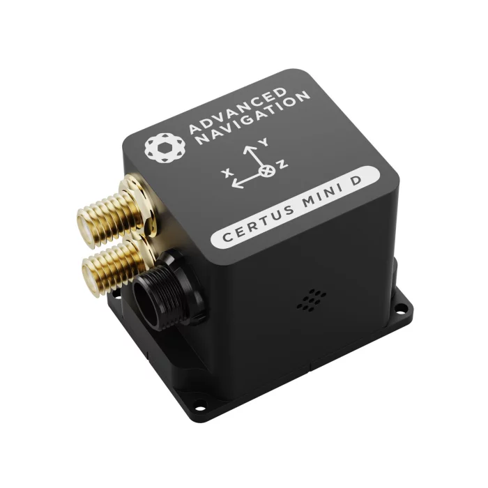
Certus Mini D
AI Navigation Algorithm
The Certus Mini range features Advanced Navigation’s revolutionary AI neural network sensor fusion algorithm.
The algorithm was designed for control applications and has a high level of health monitoring and instability prevention to ensure stable and reliable data.
High-Performance MEMS
The Certus Mini range contains high performance MEMS sensors that are put through Advanced Navigation’s intensive 8 hour temperature calibration process.
This provides the highest accuracy possible from this sensor class and outputs consistent accuracy over the full temperature range from -40°C to 85°C.
Reliability
The Certus Mini range has been designed from the ground up for mission-critical control applications where reliability is essential.
Built using a safety-oriented real-time operating system, all software is designed and tested to high safety standards with fault-tolerance in mind.
The Certus Mini range is designed, manufactured and tested to military standards.
L1/L5 Multi Constellation RTK GNSS
The Certus Mini D supports L1/L5 dual frequencies, and GPS, GLONASS, Galileo, BeiDou and NavIC constellations.
Access to multiple constellations and frequencies provides enhanced accuracy, availability and performance even in difficult environments such as multi-storey urban canyons.
The GNSS receiver has 10 mm position accuracy with real-time RTK or post-processed PPK.
Dual Antenna Heading
The Certus Mini D provides a high accuracy heading solution using two GNSS antennas. The Certus Mini D rapidly and consistently maintains an accurate heading without the need for magnetic calibration and is unaffected by magnetic interference.
Additionally, the system can determine heading while stationary. This makes it well-suited to applications where there is limited, or no, positional movement.
_700.webp)
Prolangs Inc.
Professional Defense Interpretation
Our team of interpreters, all specialists in the defense sector, brings extensive hands-on experience and relevant training. We help ensure the success of international business endeavors by acting as trusted partners to our clients.
• 24/7 defense interpretation services
• Fully equipped to deliver simultaneous, consecutive, escort, and whispering interpretation services for a variety of conferences, seminars, and official events
• Exclusive interpretation service provider for the first-ever K-Defense Day Event
◎Simultaneous interpretation
Interpretation conducted in almost real time using interpretation equipment (FM interpretation equipment, and receivers) in an interpreter booth where a pair of interpreters do the interpretation. The audience hears the interpreter's voice through the receivers. It is often used in conferences, forums, symposiums and memorials attended by a large number of people.
◎Consecutive interpretation
Unlike simultaneous interpretation, this is conducted served after a speaker's words end. It is mainly used for meetings with limited attendance, such as ministerial talks and summits.
◎Accompanying interpretation
This is similar to consecutive interpretation, but the interpreter moves with the speaker and interprets. It is mainly used for sightseeing and field trips where interpreters are needed.
◎Whispering interpretation
Interpretation for a small audience, listening to what a speaker says and then interpreting it for an audience in a quiet voice. If needed, the interpreter can use whispering equipment (transmitters and receivers).
.jpg)
PEI-Genesis
Tools
IMSAR LLC
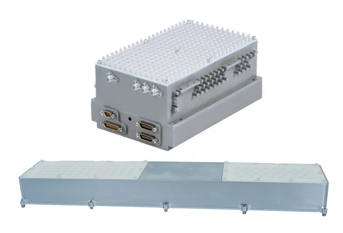
NSP-2 - IMSAR
The NSP-2 is designed for integration on Modular-Payload (MP) compliant Unmanned Airborne Systems (UAS), and each unit undergoes thorough testing to ensure its reliability.
Instead of a mechanical gimbal that requires regular maintenance, IMSAR’s NSP-2 uses an innovative 2D Electronically-Scanned Array (ESA) antenna to enable quick scanning in both azimuth and elevation.
The NSP-2 works in the Ku-band using multiple modes, such as Synthetic Aperture Radar (SAR) imaging, Magnitude Change Detection (MCD), and Ground and Maritime Moving Target Indication (MTI) at low altitudes.


_700.webp)