한국어로 페이지 보기
Seoul ADEX 2025 Digital Directory
Plan your trip to Seoul ADEX 2025 using our state of the art Digital Directory
Register in seconds with just your email


Directory Features
To help you at the show
In-depth Exhibitor Profiles
Each exhibitor can add as many products and services as they wish, with in-depth information and specifications. This allows buyers to find what they want easily.
Self Provisioning for Exhibitors
Each exhibitor has full control of their content - to edit their company profile, upload products and enter staff details.
Plan your trip
Use the bookmarking and event planning tool to research the companies you would like to visit and the products you are interested in finding. You will be able to locate all of your saved companies on our floorplan
Advanced Search
Utilize our advanced search function to quickly locate products, people, and companies. Our state-of-the-art technology thoroughly scans all exhibitor information, delivering precise and relevant results
Interactive Floorplan
Navigate the show effortlessly with our directory. Use the floorplan to locate companies you want to visit and to find your way to onsite restaurants, toilets and site entrances and exits.
On-platform Messaging
Reach out to exhibitors and visitors directly on our platform to set up meetings, or request more information.
Some of our latest content
Companies, Products, News, Events
Telcom International
NEWSPACE SYSTEM
With expertise in manufacturing guidance, navigation, and control (GNC) products, we have been used in over 2,000 spacecraft.
Adaptable for size, moment, and power to meet optimal system requirements.
Redundant windings available.
Current, speed, and torque control.
Simple digital interface to the spacecraft bus.
Hermetically sealed.
Long demonstrated lifetimes.
ISO 14644-1 state-of-the-art cleanroom facility.
ISO 9001:2015 certified.
Aeroforce Logistics, LLC
Bulit to Print Machined Parts
Stocking distributor of: aircraft landing gear, ground support, and LED lighting components
Stock for contract support - reduces cost and lead times
Build-to-print network of ISO-Certified manufactures and OEMs
Same-day-shipment of in-stock material
In-house military packaging, barcoding, RFID, and WAWF
Stock for contract support - reduces cost and lead times
Build-to-print network of ISO-Certified manufactures and OEMs
Same-day-shipment of in-stock material
In-house military packaging, barcoding, RFID, and WAWF
 (5)_700.webp)
KOREA NON-FERROUS METALS CO., LTD.
Aluminium Alloy Sheet
KNF offers high qualified Aluminium products used in a wide range of markets around the world.
*No.1 Stockholding & Qualified Aluminium Supplier
*A1XXX/A2XXX/A3XXX/A5XXX/A6XXX/A7XXX Series and more
*Business Areas: Aerospace & Defense / Semiconductor & Display / Marine & Silo / Automotive & EV Battery / Others
_700.webp)
DN Solutions
DVF series
Fast & precise 5-axis exceeds expectations
• 15000, 20000 r/min high speed spindle
• B-axis/C-axis 0.0001 degree control as standard
• Tool change time (C-T-C) 3.8s, 28% faster than previous model
• Increased X/Y/Z-axis rapid traverse speed & acc./dec.
• Cooling functions as std. on spindle, motor/LM guide/ball screw (X/Y/Z), C-axis table motor
• Integrated thermal compensation systems for spindle and structure
FURTHER INCREASED MACHINING CAPACITY
• Ø630mm dia. 2-axis tilting table, 26% increased compared to previous model
• Max. Ø600 x H500mm machining area, 32% increased compared to previous model
• Max. 400kg table load capacity with stable table support structure
• X/Y/Z axis travel distance 650/520/480mm, up to 20% increased compared to previous model
EASY ACCESS, EASIER OPERATION
• Easy setup of workpieces with 580mm distance between operator and table center
• Easy tool exchange by placing the tool magazine door on the front and applying a tool removal device (Auto Kicking Device)
• Improved chip disposal capability with enhanced coolant flood & flushing functions
• Grease lubrication system
• Compact integrated automation system (AWC)

View page in English


디렉터리 기능
전시회 도우미
In-depth Exhibitor Profiles
Each exhibitor can add as many products and services as they wish, with in-depth information and specifications. This allows buyers to find what they want easily.
Self Provisioning for Exhibitors
Each exhibitor has full control of their content - to edit their company profile, upload products and enter staff details.
방문 계획 수립
북마크 도구와 이벤트 플래너를 사용해 방문하고자 하는 기업과 관심 있는 제품을 검색하세요. 저장한 모든 항목을 조회할 수 있습니다
고급 검색
고급 검색 기능을 사용하여 상품, 인물, 기업의 위치를 빠르게 조회할 수 있습니다. 최첨단 기술을 통해 모든 참가사의 정보를 철저히 스캔하여 세밀하고 관련성 있는 정보를 제공합니다
상호작용 가능 평면도
디렉터리를 사용해 전시회를 손쉽게 둘러보세요. 방문하고자 하는 기업의 위치와, 행사장 내 식당, 화장실, 출입구를 평면도에서 찾을 수 있습니다.
플랫폼 내 메시지
플랫폼 상의 전시 참가사와 관람객에게 직접 연락하여 미팅을 신청하거나 추가 정보를 요청하세요.
최신 콘텐츠
기업, 상품, 뉴스, 이벤트
_700.webp)
JS T&C
[EPiGUARD] EpiShuttle - Medical Isolator and Transportation System
EpiShuttle is all about protecting both patients and health care professionals.
The EpiShuttle is an isolation unit designed for quick and easy transport of highly infectious and vulnerable patients.
_700.webp)
Hessed Korea
107 COMBAT SHIRT
Features
NO MELT, NO DRIP (50/50 Nylon Cotton)
Ergonomic design for comfort fit
Velcro® patch attachment on sleeves
Long sleeves with reinforced elbows
Reliable components (YKK military zipper, etc.)
Composition
Sleeves: Nylon 50%, Cotton 50%
Body: Functionalized Polyester, Polyurethane
Size
95 ~ 115
Colors
MC (MultiCam)
BMC (Black MultiCam)
BK (Black)
RG (Ranger Green)
CYT (Coyote Brown)
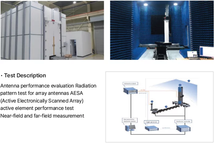
RF Systems
Antenna Measurement Technology
RF Systems' advanced facilities support accurate performance testing and RF measurement of antenna. With specialized tools and expertise, we ensure consistent quality and verified performance in all key parameters.
_700.webp)
Syscom Korea Co., Ltd.
Camera link Fiber Optic Extender FOR-30T/R , Base/Medium/Full configuration
*Perfect automatic camera matching for all types of vision cameras.
*Fully supports the Camera Link interface (Area/Line Scan).
*User-friendly,No need to modify firmware for frequency compatibility.
*Compatible with "10 TAPS@85MHz" internal/external RS232C,
all baud retes(20MHz~85MHz),and digital user IO.
*Compatible with Base/medium/Full configurations.
*Provides camera power from the Tx box.
*SFP type module
*Works with moving and non-moving fiber cables.