한국어로 페이지 보기
Seoul ADEX 2025 Digital Directory
Plan your trip to Seoul ADEX 2025 using our state of the art Digital Directory
Register in seconds with just your email


Directory Features
To help you at the show
In-depth Exhibitor Profiles
Each exhibitor can add as many products and services as they wish, with in-depth information and specifications. This allows buyers to find what they want easily.
Self Provisioning for Exhibitors
Each exhibitor has full control of their content - to edit their company profile, upload products and enter staff details.
Plan your trip
Use the bookmarking and event planning tool to research the companies you would like to visit and the products you are interested in finding. You will be able to locate all of your saved companies on our floorplan
Advanced Search
Utilize our advanced search function to quickly locate products, people, and companies. Our state-of-the-art technology thoroughly scans all exhibitor information, delivering precise and relevant results
Interactive Floorplan
Navigate the show effortlessly with our directory. Use the floorplan to locate companies you want to visit and to find your way to onsite restaurants, toilets and site entrances and exits.
On-platform Messaging
Reach out to exhibitors and visitors directly on our platform to set up meetings, or request more information.
Some of our latest content
Companies, Products, News, Events
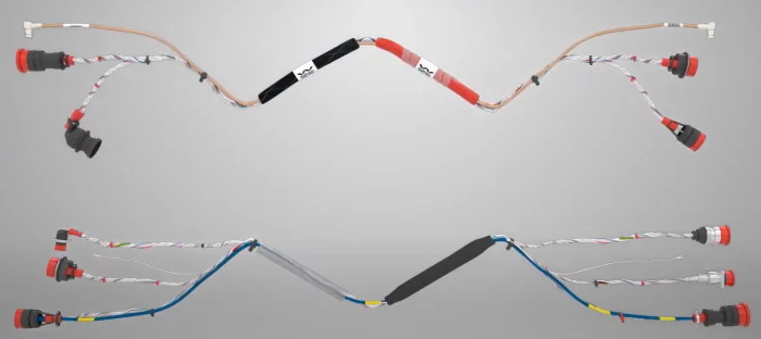
WIREMASTERS
WIRE
A wire in military or aerospace applications is a conductor used to transmit electrical power or signals between components in aircraft, vehicles, or defense systems.
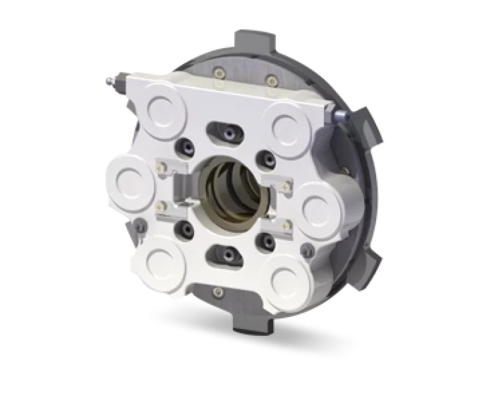
Dawin Friction
Advanced Hydraulic Braking Systems for Aircraft
Superior Performance: Stable braking power under extreme operating conditions, from taxiing to high-speed landings.
Proven Reliability: Robust structures and advanced materials that guarantee long service life with minimal maintenance.
Optimized Safety: Redundant design features and compliance with international aviation standards to meet the highest levels of operational safety.
Custom Solutions: Tailored brake designs to fit the specific requirements of fixed-wing aircraft, rotary aircraft, and unmanned aerial platforms.
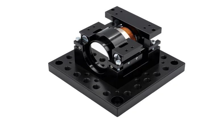
MPS bearings Co., Ltd.
High-Dynamics Voice-Coil Nano-Positioner
Developed by MPS Microsystems, the voice-coil nano-positioner unites a Lorentz-force motor, flexure guidance and on-board electronics inside a 65 × 60 × 38 mm envelope. Standard travel is 2.88 mm, extendable to 7 mm with the same coil, suiting microscope objectives, small mirrors and sensors that demand friction-free motion.
Bidirectional repeatability stays within ±1 µm over a 360 µm stroke and ±2.5 µm across the full stroke. We can tailor mounting plates, objective clamps and cable exits to suit your specific requirements, ensuring that this voice-voil actuator can be integrated seamlessly into your system.
Marvin Test Solutions
Marvin Test Solutions - We Make Test Easy™
Marvin Test Solutions, a vertically integrated aerospace test and measurement company, has designed and delivered innovative, feature-rich solutions for the ...

View page in English


디렉터리 기능
전시회 도우미
In-depth Exhibitor Profiles
Each exhibitor can add as many products and services as they wish, with in-depth information and specifications. This allows buyers to find what they want easily.
Self Provisioning for Exhibitors
Each exhibitor has full control of their content - to edit their company profile, upload products and enter staff details.
방문 계획 수립
북마크 도구와 이벤트 플래너를 사용해 방문하고자 하는 기업과 관심 있는 제품을 검색하세요. 저장한 모든 항목을 조회할 수 있습니다
고급 검색
고급 검색 기능을 사용하여 상품, 인물, 기업의 위치를 빠르게 조회할 수 있습니다. 최첨단 기술을 통해 모든 참가사의 정보를 철저히 스캔하여 세밀하고 관련성 있는 정보를 제공합니다
상호작용 가능 평면도
디렉터리를 사용해 전시회를 손쉽게 둘러보세요. 방문하고자 하는 기업의 위치와, 행사장 내 식당, 화장실, 출입구를 평면도에서 찾을 수 있습니다.
플랫폼 내 메시지
플랫폼 상의 전시 참가사와 관람객에게 직접 연락하여 미팅을 신청하거나 추가 정보를 요청하세요.
최신 콘텐츠
기업, 상품, 뉴스, 이벤트

NOVA MODUL SRL
RAK1 M Rifle
A reliable, quality full or semi-auto version of the rifle that has written entire volumes in history.
A basic, non-nonsense version that stays true to the original.
_700.webp)
HANMI HYDRAULIC MACHINERY CO., LTD.
A-ECL Oil Supply Unit
Original compact design and long-term production know-how.
System reliability and overall competitiveness.
_700.webp)
Panoptics Co., Ltd
Broadband Low Noise Amplifer & Filter
Low noise in Ultra broadband range (kHz~6GHz or 1GHz~18GHz)
Now price, short delivery, Good technical service compared with global maker.
_700.webp)
funzin
KWM-Ocelot
Solution Overview
KWM-Ocelot (AI Electromagnetic Spectrum Reconnaissance System) is a self-developed solution that measures field strength and clearness of 5G/4G base station signals and automatically analyzes abnormal waveforms based on time-series data.
Main Features
Real-time wideband frequency scanning using an RF detector mounted on unmanned complex systems
AI-based signal characteristics and transmitter location analysis
Real-time transmission and visualization of analysis data to ground control stations (GCS) via data link
Identification of locations such as enemy drone and equipment operation areas, and command posts
Effective tracking and jamming of enemy communications
Key Advantages
Automated signal classification and pattern learning based on AI
Real-time visualization of battlefield electromagnetic spectrum distribution
Effective signal detection, analysis, and tracking in various military environments
Fully in-house developed, enabling rapid technological application and operational optimization
Applied Cases
Winner of the Grand Prize (Army Chief of Staff Award) at the 2025 Army Artificial Intelligence Idea Contest
Real-time reconnaissance of battlefield electromagnetic environments and enemy communication tracking in military operations