한국어로 페이지 보기
Seoul ADEX 2025 Digital Directory
Plan your trip to Seoul ADEX 2025 using our state of the art Digital Directory
Register in seconds with just your email


Directory Features
To help you at the show
In-depth Exhibitor Profiles
Each exhibitor can add as many products and services as they wish, with in-depth information and specifications. This allows buyers to find what they want easily.
Self Provisioning for Exhibitors
Each exhibitor has full control of their content - to edit their company profile, upload products and enter staff details.
Plan your trip
Use the bookmarking and event planning tool to research the companies you would like to visit and the products you are interested in finding. You will be able to locate all of your saved companies on our floorplan
Advanced Search
Utilize our advanced search function to quickly locate products, people, and companies. Our state-of-the-art technology thoroughly scans all exhibitor information, delivering precise and relevant results
Interactive Floorplan
Navigate the show effortlessly with our directory. Use the floorplan to locate companies you want to visit and to find your way to onsite restaurants, toilets and site entrances and exits.
On-platform Messaging
Reach out to exhibitors and visitors directly on our platform to set up meetings, or request more information.
Some of our latest content
Companies, Products, News, Events
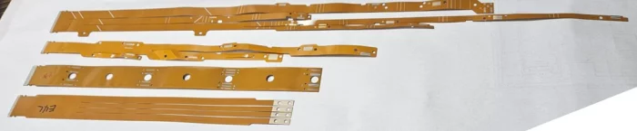
SAMKEE ENERGY SOLUTIONS
Flat Flexible Pattern Cable Board
Innovative BMS sensing cable that allows the assembly (SMT) of components onto the pattern circuit without any length restrictions (0.1~3m) using the Roll-to-Roll process, and The manufacturing process of the conventional BMS sensing cable is shortened to 1/3.
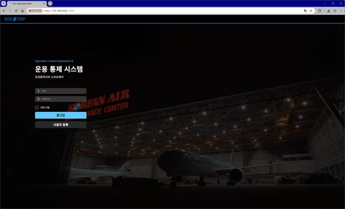
SOLETOP
Operation Control System
- Within the aircraft exterior inspection system, data aggregation and transmission are provided.
- Data collection and storage via the server are provided.
- User authentication and other system management are provided.
- User interfaces are provided for administrators.
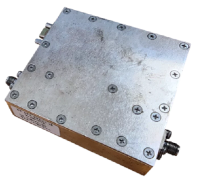
Eltronix Co., Inc
Ku-band AMP Module
The Ku-band Amplifier Module is a low-power amplifier designed to amplify the LO (Local Oscillator) frequency in the Ku-band.
It provides a gain of at least 17 dB and an output level of 13 dBm or higher.
The module includes a built-in monitoring function for output signal detection.
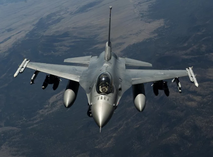
Shield AI
Hivemind - Jets
THE FUTURE OF FIGHTER JETS
With a 99% win-rate in simulated F-16 dogfights versus active-duty Air Force and Navy fighter pilots, Hivemind is learning to execute a variety of missions from Beyond Visual Range strike to suppression of enemy air defense. The future of air dominance will be powered and flown by Hivemind.
It Starts With The F-16
Hivemind will deploy as a digital co-pilot on a U.S. Air Force F-16, with the goal of rapidly scaling across next-generation aircraft, F-22s, F-18s, and other fighter jets. Hivemind will make legacy fighters relevant for decades to come and will power the next generation of military aircraft.

View page in English


디렉터리 기능
전시회 도우미
In-depth Exhibitor Profiles
Each exhibitor can add as many products and services as they wish, with in-depth information and specifications. This allows buyers to find what they want easily.
Self Provisioning for Exhibitors
Each exhibitor has full control of their content - to edit their company profile, upload products and enter staff details.
방문 계획 수립
북마크 도구와 이벤트 플래너를 사용해 방문하고자 하는 기업과 관심 있는 제품을 검색하세요. 저장한 모든 항목을 조회할 수 있습니다
고급 검색
고급 검색 기능을 사용하여 상품, 인물, 기업의 위치를 빠르게 조회할 수 있습니다. 최첨단 기술을 통해 모든 참가사의 정보를 철저히 스캔하여 세밀하고 관련성 있는 정보를 제공합니다
상호작용 가능 평면도
디렉터리를 사용해 전시회를 손쉽게 둘러보세요. 방문하고자 하는 기업의 위치와, 행사장 내 식당, 화장실, 출입구를 평면도에서 찾을 수 있습니다.
플랫폼 내 메시지
플랫폼 상의 전시 참가사와 관람객에게 직접 연락하여 미팅을 신청하거나 추가 정보를 요청하세요.
최신 콘텐츠
기업, 상품, 뉴스, 이벤트
AIR COST CONTROL
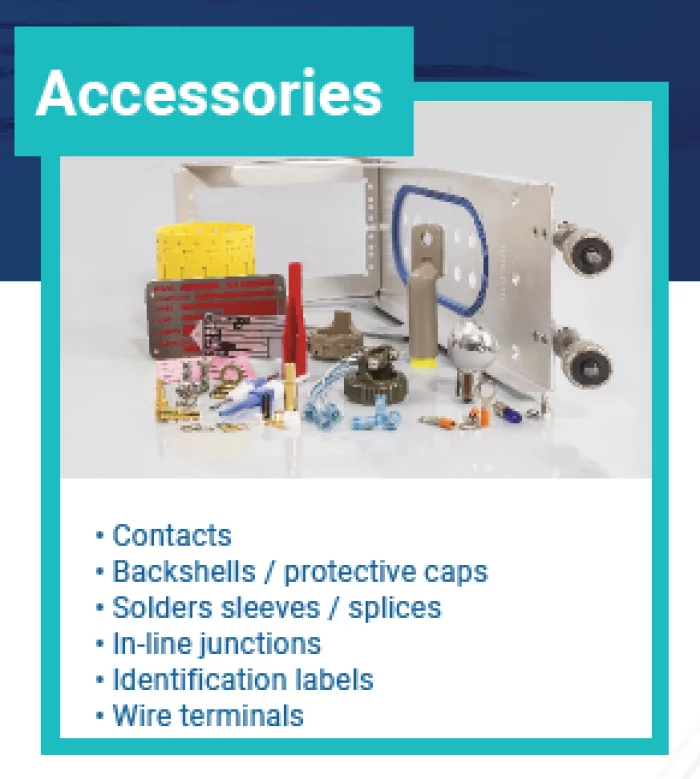
Accessories
• Contacts
• Backshells / protective caps
• Solders sleeves / splices
• In-line junctions
• Identification labels
• Wire terminals
SM CNS
Tracking Radars
Weibel’s Doppler 3D tracking radars are designed for precise measurements of free-flying objects such as projectiles, artillery rounds, and rockets. The systems are highly effective for detailed debris tracking, range safety tests, missile tests, and space launches.
Weibel’s tracking radars are phased array X-band CW, MFCW and FMCW radar systems consisting of state of the art phased array Doppler radar antennas, high performance pedestals, real-time multi-object tracking processors and state of the art waveform generators, all controlled from the operator console.
Invest Quebec
BRP
Ski-Doo·Sea-Doo·Can-Am 등 아이코닉 브랜드를 보유한 글로벌 레저 모빌리티 선도기업으로, 스노모빌·수상 레저·ATV/사이드바이사이드·3륜 모토사이클과 Rotax 엔진까지 폭넓은 제품군을 제공합니다. 방위 산업업체와도 협력을 모색합니다.
XMW Inc.
SATCOM RF Transmitters/Receivers
A comprehensive line of products in C, X, Ku, Ka and Q-band for SATCOM and 5G&6G are available as off-the-shelf items or custom-made design upon request. These products are specialized in various types of mobility environment including airborne application. We serve the customers in more than 20 countries with fully field proven products.
The new era of wireless communication requires a converged solution of SATCOM and 5G&6G in the aspects of technologies and services. XMW is preparing for the new era with the solutions inherited from SATCOM and 5G&6G business for more than a decade.