한국어로 페이지 보기
Seoul ADEX 2025 Digital Directory
Plan your trip to Seoul ADEX 2025 using our state of the art Digital Directory
Register in seconds with just your email


Directory Features
To help you at the show
In-depth Exhibitor Profiles
Each exhibitor can add as many products and services as they wish, with in-depth information and specifications. This allows buyers to find what they want easily.
Self Provisioning for Exhibitors
Each exhibitor has full control of their content - to edit their company profile, upload products and enter staff details.
Plan your trip
Use the bookmarking and event planning tool to research the companies you would like to visit and the products you are interested in finding. You will be able to locate all of your saved companies on our floorplan
Advanced Search
Utilize our advanced search function to quickly locate products, people, and companies. Our state-of-the-art technology thoroughly scans all exhibitor information, delivering precise and relevant results
Interactive Floorplan
Navigate the show effortlessly with our directory. Use the floorplan to locate companies you want to visit and to find your way to onsite restaurants, toilets and site entrances and exits.
On-platform Messaging
Reach out to exhibitors and visitors directly on our platform to set up meetings, or request more information.
Some of our latest content
Companies, Products, News, Events

ALA
ALA Services
ALA specializes in lean supply chain management solutions to deliver significant benefits to its Customers’ operations. These solutions include: supplier relationship management, inventory management, material planning, Just-In-Time deliveries, third-party logistics, consignment material management, Direct Line Feed, and Kitting.
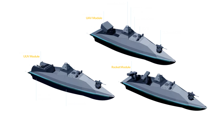
Hanwha Ocean Co., Ltd.
Modular USV
· Wide-area situational awareness through omni-directional cameras and EO/IR sensors
· Seamless remote control enabled by LEO satellite communication and USV teaming operation
· Multi mission capabilities by interchangeable mission modules such as UUV, UAV and compact rocket modules
.jpg)
PEI-Genesis
Cinch ModICE® Enclosures
.jpg)
Marvin Test Solutions
Datasheets (PDF)

View page in English


디렉터리 기능
전시회 도우미
In-depth Exhibitor Profiles
Each exhibitor can add as many products and services as they wish, with in-depth information and specifications. This allows buyers to find what they want easily.
Self Provisioning for Exhibitors
Each exhibitor has full control of their content - to edit their company profile, upload products and enter staff details.
방문 계획 수립
북마크 도구와 이벤트 플래너를 사용해 방문하고자 하는 기업과 관심 있는 제품을 검색하세요. 저장한 모든 항목을 조회할 수 있습니다
고급 검색
고급 검색 기능을 사용하여 상품, 인물, 기업의 위치를 빠르게 조회할 수 있습니다. 최첨단 기술을 통해 모든 참가사의 정보를 철저히 스캔하여 세밀하고 관련성 있는 정보를 제공합니다
상호작용 가능 평면도
디렉터리를 사용해 전시회를 손쉽게 둘러보세요. 방문하고자 하는 기업의 위치와, 행사장 내 식당, 화장실, 출입구를 평면도에서 찾을 수 있습니다.
플랫폼 내 메시지
플랫폼 상의 전시 참가사와 관람객에게 직접 연락하여 미팅을 신청하거나 추가 정보를 요청하세요.
최신 콘텐츠
기업, 상품, 뉴스, 이벤트

SAFRAN
Products & services
Safran Electrical & Power offers a wide range of AC & DC contactors & relays designed for aircraft, rotorcraft and harsh environment applications. Multiple voltage levels, ratings, mounting types and auxiliary contact arrangements are available to match any application.
_700.webp)
DIGITRON. Co., Ltd.
RED/GREEN POSITION LIGHT
- A red light mounted on the left side of the aircraft to indicate the aircraft's location
- A green light mounted on the right side of the aircraft to indicate the aircraft's location
- These lights indicate the aircraft's position, flight direction, and attitude
- Visible/IR Mode, Steady/Flash Mode
- Light Intensity : FAA FAR 29.1391 ~ 29.1395
- SAE ARP 5825A
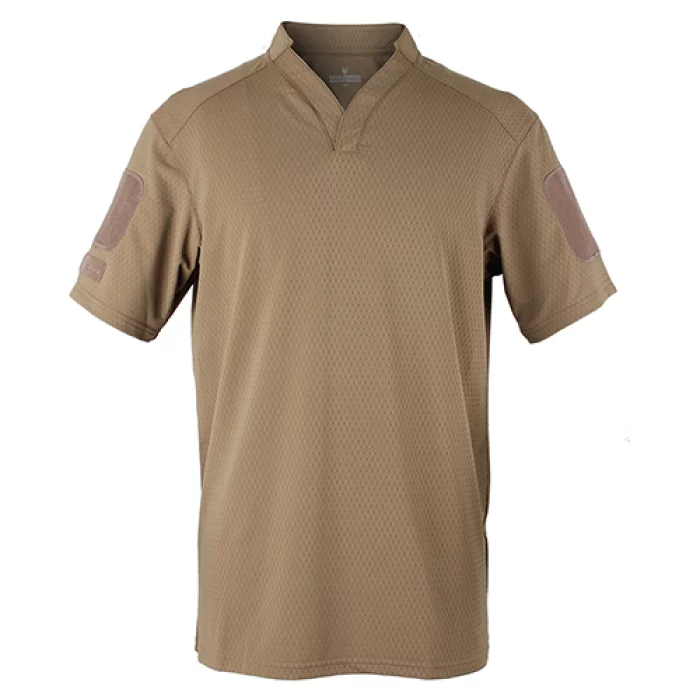
Hessed Korea
RUGBY SHIRT
Cool comfort fit and excellent elasticity with Nylon & Span materials
Enhanced breathability & moisture absorption with mesh fabrics
Applied Velcro® to sleeve for patch attachment
V-neck / Round-neck design
Long Sleeve / Short Sleeve
Composition
Material : NY80/PU20 High Gauge Trichord (Nylon & Span)
Size
95 ~ 115
Colors
BK (Black)
RG (Ranger Green)
CYT (Coyote Brown)

ACEWAVETECH
EW Receiver Test System
- RWR receiver inspection and antenna performance measurement
- EW receiver inspection
- Check the azimuth and signal power of the RWR receiver