한국어로 페이지 보기
Seoul ADEX 2025 Digital Directory
Plan your trip to Seoul ADEX 2025 using our state of the art Digital Directory
Register in seconds with just your email


Directory Features
To help you at the show
In-depth Exhibitor Profiles
Each exhibitor can add as many products and services as they wish, with in-depth information and specifications. This allows buyers to find what they want easily.
Self Provisioning for Exhibitors
Each exhibitor has full control of their content - to edit their company profile, upload products and enter staff details.
Plan your trip
Use the bookmarking and event planning tool to research the companies you would like to visit and the products you are interested in finding. You will be able to locate all of your saved companies on our floorplan
Advanced Search
Utilize our advanced search function to quickly locate products, people, and companies. Our state-of-the-art technology thoroughly scans all exhibitor information, delivering precise and relevant results
Interactive Floorplan
Navigate the show effortlessly with our directory. Use the floorplan to locate companies you want to visit and to find your way to onsite restaurants, toilets and site entrances and exits.
On-platform Messaging
Reach out to exhibitors and visitors directly on our platform to set up meetings, or request more information.
Some of our latest content
Companies, Products, News, Events
NIDV
Trade promotion
The NIDV supports its members in both national and international markets in as many ways as possible. From participation in international projects, international trade fair visits to programmes with government support. You can find more information about these initiatives below.
_700.webp)
TelePIX Co., Ltd.
BlueBON
The world’s first satellite dedicated to blue carbon monitoring, launched in January 2025. Equipped with an AI-powered onboard processor, BlueBON processes electro-optical data directly in orbit, reducing latency and eliminating the need for energy-intensive ground-based processing. This establishes a new model for sustainable, application-driven EO missions.

Honeywell International
Get Ready with Industrial-Grade Software
The intelligent operations you didn't know existed - and didn't know you needed. Let data be your co-pilot with Honeywell Forge industrial-grade software.Fol...
Finished Solution
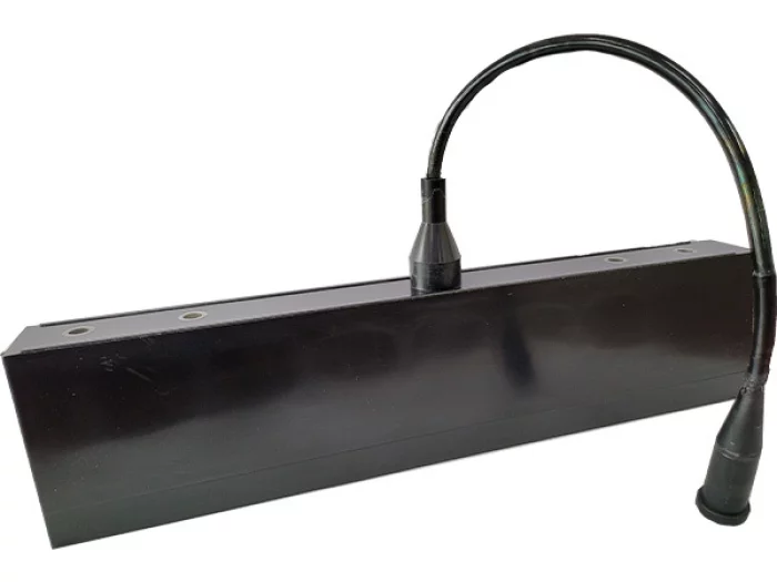
SONAR SENSOR
Iniaturization model for UAVs
Minimized Vibration & Noise by our technique
Provide an electronic board
Customized item for Military's needs

View page in English


디렉터리 기능
전시회 도우미
In-depth Exhibitor Profiles
Each exhibitor can add as many products and services as they wish, with in-depth information and specifications. This allows buyers to find what they want easily.
Self Provisioning for Exhibitors
Each exhibitor has full control of their content - to edit their company profile, upload products and enter staff details.
방문 계획 수립
북마크 도구와 이벤트 플래너를 사용해 방문하고자 하는 기업과 관심 있는 제품을 검색하세요. 저장한 모든 항목을 조회할 수 있습니다
고급 검색
고급 검색 기능을 사용하여 상품, 인물, 기업의 위치를 빠르게 조회할 수 있습니다. 최첨단 기술을 통해 모든 참가사의 정보를 철저히 스캔하여 세밀하고 관련성 있는 정보를 제공합니다
상호작용 가능 평면도
디렉터리를 사용해 전시회를 손쉽게 둘러보세요. 방문하고자 하는 기업의 위치와, 행사장 내 식당, 화장실, 출입구를 평면도에서 찾을 수 있습니다.
플랫폼 내 메시지
플랫폼 상의 전시 참가사와 관람객에게 직접 연락하여 미팅을 신청하거나 추가 정보를 요청하세요.
최신 콘텐츠
기업, 상품, 뉴스, 이벤트
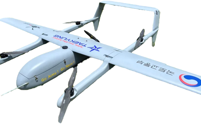
TAEKYUNG ELEC. Co., LTD.
e-VTOL-350
Our e-VTOL drone offers versatile vertical take-off and landing capabilities with precise and stable flight. Equipped with advanced sensors and real-time camera monitoring, it ensures safe and efficient operations in diverse environments.
_700.webp)
X-BEAM TECH
Expanded Beam Connector HXB Series
The X-BEAM TECH HXB Connectors, featuring expanded beam technology, hermaphroditic connection, rugged construction for field deployment have been designed for harsh environment applications such as military tactical communications, avionics, offshore systems, outside broadcast, mining and plant.
The expanded beam technology uses expanded and collimated beams to couple optical fibers without any contact. It could allow for optics to be used in areas that have been quite restrictive due to presence of damage or contamination at the fiber end. Hermaphroditic connector design enables fast deployment by daisy-chaining multiple cable segments. HXB series connectors also enable transfer of electrical signal or power using hybrid insert configuration.
The expanded beam technology uses expanded and collimated beams to couple optical fibers without any contact. It could allow for optics to be used in areas that have been quite restrictive due to presence of damage or contamination at the fiber end. Hermaphroditic connector design enables fast deployment by daisy-chaining multiple cable segments. HXB series connectors also enable transfer of electrical signal or power using hybrid insert configuration.
_700.webp)
HYUNDAI WIA Corp.
AI Based Intelligent RCWS
1. RCWS
- 7.62mm Machine Gun (Compatible of K-16 and M60)
- Magazine Capacity : Max. 400 Rounds.
2. EO/IR
- Day/Night Range : Detection 4 Km, Recongnition 2 Km
- Range Finding Accuracy : less 5m in 4 Km
3. AI Object Recognition
- Real-time Object Detection Model
- GPU-Based High Speed AI image Processing
- Application of Supervised Learning Data

RF Systems
Maritime Warfare System
PROJECTS
KSS SONAR System
KDX-III SONAR System
Wire-Guided Heavyweight Torpedo
Harbor Underwater Surveillance System (HUSS)
ITEMS
Transceiver cabinet assembly