한국어로 페이지 보기
Seoul ADEX 2025 Digital Directory
Plan your trip to Seoul ADEX 2025 using our state of the art Digital Directory
Register in seconds with just your email


Directory Features
To help you at the show
In-depth Exhibitor Profiles
Each exhibitor can add as many products and services as they wish, with in-depth information and specifications. This allows buyers to find what they want easily.
Self Provisioning for Exhibitors
Each exhibitor has full control of their content - to edit their company profile, upload products and enter staff details.
Plan your trip
Use the bookmarking and event planning tool to research the companies you would like to visit and the products you are interested in finding. You will be able to locate all of your saved companies on our floorplan
Advanced Search
Utilize our advanced search function to quickly locate products, people, and companies. Our state-of-the-art technology thoroughly scans all exhibitor information, delivering precise and relevant results
Interactive Floorplan
Navigate the show effortlessly with our directory. Use the floorplan to locate companies you want to visit and to find your way to onsite restaurants, toilets and site entrances and exits.
On-platform Messaging
Reach out to exhibitors and visitors directly on our platform to set up meetings, or request more information.
Some of our latest content
Companies, Products, News, Events

Ho-Ho-Kus, Inc.
Wheels and brakes
Our products include brake clips and brackets.
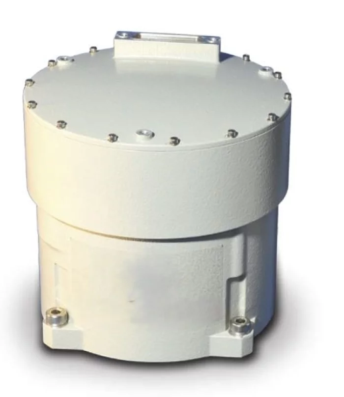
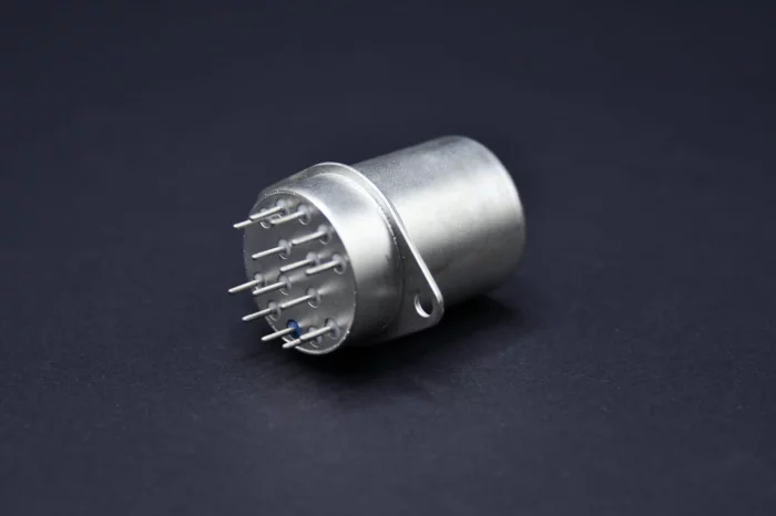
EMCORE
SUPER TAC IMU - Super-Tactical (TAC) Inertial Measurement Unit (IMU
The new Super-TAC IMU integrates three fiber optic gyros that exceed tactical grade performance with three high-accuracy Micro-Electro-Mechanical Systems (MEMS) accelerometers and state-of-the-art support electronics in a single small, lightweight package. This solution addresses the need for superior inertial performance in a tactical- grade package, critical for operation in GPS denied and contested environments.
The Super-TAC IMU measures change in velocity and angle, utilizing a configurable variable synchronous data link control (SDLC) digital serial bus. The Super-TAC is configured to offer customers the best value solution when designing new systems as well as provide the flexibility to upgrade existing platforms.
The Super-TAC IMU employs state-of-the-art optics with fewer components, providing significant performance and reliability improvements across standard military environments.
Background
Emcore, located in Budd Lake, NJ has been designing, developing and producing inertial components, sensors and navigation systems for Space, Ground, and Avionic applications for over 35 years. Emcore has been developing Fiber Optic Gyros (FOGs) since the early 1990s, producing and delivering IMU products with performance ranging from tactical to strategic grade
PERFORMANCE
GYRO PERFORMANCE
Bias Stability < 0.05 °/hr. (1σ)
Angle Random Walk ( ARW) ≤ 0.01 °/√hr. (1σ)
Scale Factor Repeatability ≤ 100 ppm (1σ)
Scale Factor Linearity ≤ 50 ppm (1σ)
Angular Rate Range 1,000 °/sec
Acceleration Range 100,000 °/sec2
ACCELEROMETER PERFORMANCE
Range ± 25 g
Bias Variation ≤ 50 μg (1σ)
Scale Factor Stability ≤ 300 ppm (1σ)
SYSTEM PERFORMANCE
Bandwidth (adjustable) 800 Hz (gyros)
150 Hz (accelerometers)
MTBF >25,000 hr.
GnK Solution
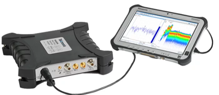
RSA507A
Portable Real time USB signal analyzer, 9 kHz-7.5 GHz
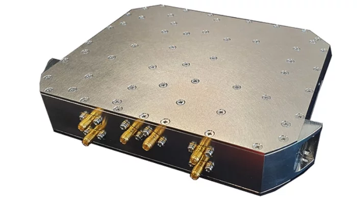
J Labs
W-band frequency synthesizer
Product Information
Frequency signal generator for high-performance, high-precision target detection
High-frequency resolution design and frequency conversion function using DDS method
main performance
Frequency: L-Band ~ X-Band
Pulse Mode, Low spurious
Output Level: -10~+15dBm Range
Spurious: -55dBc min
Harmonic: -50dBc min
Phase Noise: High Performance
Frequency Sensibility: 50ppm max
Port isolation: 70dBc Min
Applicable fields
High-precision targeting guided weapon tower system and radar system can be applied

View page in English


디렉터리 기능
전시회 도우미
In-depth Exhibitor Profiles
Each exhibitor can add as many products and services as they wish, with in-depth information and specifications. This allows buyers to find what they want easily.
Self Provisioning for Exhibitors
Each exhibitor has full control of their content - to edit their company profile, upload products and enter staff details.
방문 계획 수립
북마크 도구와 이벤트 플래너를 사용해 방문하고자 하는 기업과 관심 있는 제품을 검색하세요. 저장한 모든 항목을 조회할 수 있습니다
고급 검색
고급 검색 기능을 사용하여 상품, 인물, 기업의 위치를 빠르게 조회할 수 있습니다. 최첨단 기술을 통해 모든 참가사의 정보를 철저히 스캔하여 세밀하고 관련성 있는 정보를 제공합니다
상호작용 가능 평면도
디렉터리를 사용해 전시회를 손쉽게 둘러보세요. 방문하고자 하는 기업의 위치와, 행사장 내 식당, 화장실, 출입구를 평면도에서 찾을 수 있습니다.
플랫폼 내 메시지
플랫폼 상의 전시 참가사와 관람객에게 직접 연락하여 미팅을 신청하거나 추가 정보를 요청하세요.
최신 콘텐츠
기업, 상품, 뉴스, 이벤트
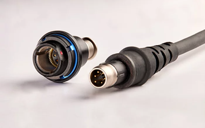
BERNIER connect S.A.S
NWA series
STANAG 4695 & GOSSRA*
* GENERIC OPEN SOLDIER SYSTEM REFERENCE ARCHITECTURE
compatible with Nett Warrior
BREAK-AWAY CONNECTOR
Invest Quebec
CEL Aerospace
항공 엔진용 테스트셀·시험장비 및 데이터 솔루션을 설계·구축하는 세계적 기업으로, 상업·국방·MRO 고객의 터보팬/터보샤프트/APU 등 다양한 엔진 시험 요구를 지원합니다.
ARS ELECTRONICS S.r.l.
RELAYS
ELECTROMECHANICAL RELAYS
_700.webp)
LUMIR
Image Data Handling Unit, IDHU
Lumir is the first Korean company to successfully develop and manufacture this onboard equipment, delivering superior performance and significant cost savings compared to competitors’ products. By integrating non-volatile NAND flash devices into the image data handling unit, storage capacity has been significantly increased, with data retention maintained even when the power is off.The image data handling unit of the satellite is a core device that receives high-speed, large-capacity data output from Earth observation sensors mounted on the satellite—such as SAR or optical cameras—then compresses and stores the data in real time, while also performing encryption and encoding for transmission to ground stations. Lumir has successfully developed and manufactured this satellite-mounted device domestically in Korea for the first time, breaking reliance on imported technologies. This achievement secures Lumir’s competitiveness by delivering superior performance and significant cost savings compared to foreign products.