한국어로 페이지 보기
Seoul ADEX 2025 Digital Directory
Plan your trip to Seoul ADEX 2025 using our state of the art Digital Directory
Register in seconds with just your email


Directory Features
To help you at the show
In-depth Exhibitor Profiles
Each exhibitor can add as many products and services as they wish, with in-depth information and specifications. This allows buyers to find what they want easily.
Self Provisioning for Exhibitors
Each exhibitor has full control of their content - to edit their company profile, upload products and enter staff details.
Plan your trip
Use the bookmarking and event planning tool to research the companies you would like to visit and the products you are interested in finding. You will be able to locate all of your saved companies on our floorplan
Advanced Search
Utilize our advanced search function to quickly locate products, people, and companies. Our state-of-the-art technology thoroughly scans all exhibitor information, delivering precise and relevant results
Interactive Floorplan
Navigate the show effortlessly with our directory. Use the floorplan to locate companies you want to visit and to find your way to onsite restaurants, toilets and site entrances and exits.
On-platform Messaging
Reach out to exhibitors and visitors directly on our platform to set up meetings, or request more information.
Some of our latest content
Companies, Products, News, Events
_700.webp)
K-DEFENSE Co., Ltd.
SCBA(Self-Contained Breathing Apparatus)
1. Certification Status
Certified by the Korea Fire Institute (KFI)
Certified under the latest KFAC (Korea Fire-fighting Apparatus Certification)
CE certification currently in progress
2. Product Description
Composition: Backrest, Facepiece, Cylinder
Accessories: Auxiliary Mask, Bone Conduction Communication Device (facepiece- or headset-mounted), HUD, etc.
3. Features and Benefits
-> Wide Full Face Mask: 360° curvature reduces blind spots. Medical-grade silicone minimizes skin irritation during long-term use. Equipped with a 360° rotating supply valve.
-> Type-4 Containers: Internal PET liner prevents contamination. 20% lighter than Type-3 containers. Built-in Excess Flow Valve (EFV) protects against emergency damage in case of container breakage.
-> IT-Integrated Backplate: Features a thermal imaging pressure indicator with TIC camera, PASS life-saving alarm, ambient temperature and height display, container pressure and remaining time, visual/audible alarms, Bluetooth connectivity, and NFC-based crew monitoring (entry/exit logs). Includes weight-distributing design and rapid charging function.
-> Flexible Pricing: Various models are available with different features and price points, allowing selection based on individual needs.
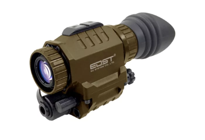
EO System
Night Vision Goggle
NVS, Night Vision Scope is designed for individual soldiers and law enforcement personnel which has been already in operation all around the world.
This device gives soldiers and law enforcement the versatility they need to engage in operations with optimum efficiency.
_700.webp)
Ray Service, A.S.
Manufacturing of Cable Harnesses
Ray Service, headquartered in Staré Město, Czech Republic, is an international innovative manufacturer of cable harnesses, electromechanical assemblies, and electronic equipment. It is also a distributor and integrator of cable components and system products. More than 30 years of experience and intensive development have resulted in a strong, modern enterprise, a reliable and sought-after partner on an international level.
Sangdo Electronics co.,Ltd
Hypertac Green Connect
Hypertac Green ConnectTM Contact Technology offers a Lead-free and Beryllium-free high power contact solution with unparallel low contact resistance. The lower contact resistance of the Hypertac Green Connect hyperboloid contact reduces heat build-up allowing the contacts able to handle far greater current in smaller contact assemblies without adversely effecting temperature rise. Thanks to the improved crimp design of the socket offering an increased contact area between the contact body and the multi-stranded cable, Hypertac Green ConnectTM solution can offer an unrivalled low contact resistance.

View page in English


디렉터리 기능
전시회 도우미
In-depth Exhibitor Profiles
Each exhibitor can add as many products and services as they wish, with in-depth information and specifications. This allows buyers to find what they want easily.
Self Provisioning for Exhibitors
Each exhibitor has full control of their content - to edit their company profile, upload products and enter staff details.
방문 계획 수립
북마크 도구와 이벤트 플래너를 사용해 방문하고자 하는 기업과 관심 있는 제품을 검색하세요. 저장한 모든 항목을 조회할 수 있습니다
고급 검색
고급 검색 기능을 사용하여 상품, 인물, 기업의 위치를 빠르게 조회할 수 있습니다. 최첨단 기술을 통해 모든 참가사의 정보를 철저히 스캔하여 세밀하고 관련성 있는 정보를 제공합니다
상호작용 가능 평면도
디렉터리를 사용해 전시회를 손쉽게 둘러보세요. 방문하고자 하는 기업의 위치와, 행사장 내 식당, 화장실, 출입구를 평면도에서 찾을 수 있습니다.
플랫폼 내 메시지
플랫폼 상의 전시 참가사와 관람객에게 직접 연락하여 미팅을 신청하거나 추가 정보를 요청하세요.
최신 콘텐츠
기업, 상품, 뉴스, 이벤트
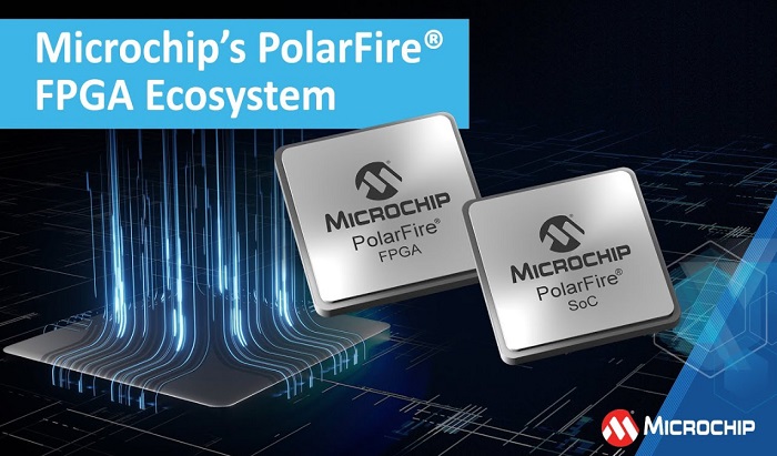
Microchip Technology Inc.
Microchip's PolarFire® FPGA Ecosystem
The PolarFire FPGA and PolarFire SoC families already deliver the industry’s best thermal and power efficiency in the mid-range segment. Optimized for deploying systems with high-compute performance in small form factors, the families have reduced the size and weight of power-constrained systems in applications including industrial imaging, robotics, AI-enabled medical systems and smart defense and aerospace systems.
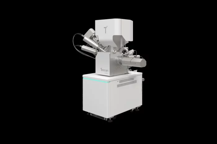
Tescan Group a.s.
TESCAN Plasma FIB-SEM, AMBER X2
An optimized Plasma FIB-SEM platform with proprietary gas chemistries for high-quality delayering of the most current semiconductor devices
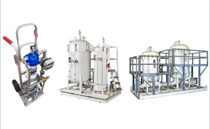
LEES Corporation
System Skid
Oil filter/transfer cart
: Mobile fueling cart that supports oil filtering, flow rate check, and transfer functions
oil system skid
: Each part that enables oil transfer, filtering, flow rate check, and refueling in the oil tank is compactly configured with a skid for easy use and installation of the system.
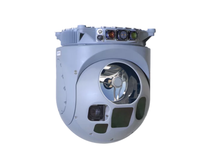
SAFRAN
EUROFLIR 410
The Euroflir™ 410 family allows fixed, rotary-wing aircraft & UAV to carry out, in any conditions, intelligence, protection, search and rescue missions thanks to long-range observation and accurate targeting and designation capabilities.
Very-high-resolution multispectral cameras
Euroflir™ 410 operates in four spectral wavebands - TV, NIR, SWIR, MWIR – with a wide field-of-view and ultra-long-range observation, allowing it to function at standoff distance any time day or night. The Euroflir™ 410 is specially adapted to the wide variety of missions: supporting law enforcement, homeland security, border and coastal surveillance, intelligence, SAR and CSAR.
Euroflir™ 410 : a modular system in 3 main versions
EuroflirTM 410 Surveillance: eyesafe target range measurement and 3D location-determination.
EuroflirTM 410 Marking: target marking for either crew members or allied ground forces with night vision goggles.
EuroflirTM 410 Designation: accurate designation with suitable laser coding for laser-guided weapons.
Advanced embedded functions
Improved situational awareness: moving map & augmented reality (visualize the line-of-sight, define points of interest on a digital map, real-time video).
Automatic detection: Moving Target Indicators (MTI) & Hot Spot Detection (HSD).
Enhanced identification: Super resolution & Fusion.