한국어로 페이지 보기
Seoul ADEX 2025 Digital Directory
Plan your trip to Seoul ADEX 2025 using our state of the art Digital Directory
Register in seconds with just your email


Directory Features
To help you at the show
In-depth Exhibitor Profiles
Each exhibitor can add as many products and services as they wish, with in-depth information and specifications. This allows buyers to find what they want easily.
Self Provisioning for Exhibitors
Each exhibitor has full control of their content - to edit their company profile, upload products and enter staff details.
Plan your trip
Use the bookmarking and event planning tool to research the companies you would like to visit and the products you are interested in finding. You will be able to locate all of your saved companies on our floorplan
Advanced Search
Utilize our advanced search function to quickly locate products, people, and companies. Our state-of-the-art technology thoroughly scans all exhibitor information, delivering precise and relevant results
Interactive Floorplan
Navigate the show effortlessly with our directory. Use the floorplan to locate companies you want to visit and to find your way to onsite restaurants, toilets and site entrances and exits.
On-platform Messaging
Reach out to exhibitors and visitors directly on our platform to set up meetings, or request more information.
Some of our latest content
Companies, Products, News, Events
.jpg)
GE Aerospace
GE's F110: The Engine of Choice for Today's Front-Line Missions
Powering front-line fighters globally and backed by a continuous infusion of new technology, the F110 remains the engine of choice around the world.
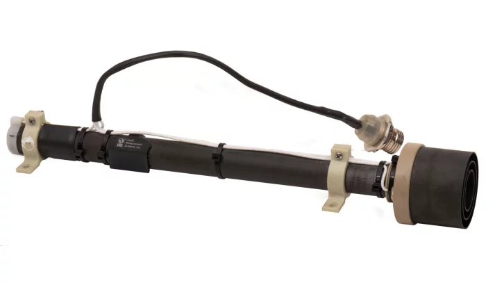
LMS
Carbon Composite Fuel Quantity Probes
Liquid Measurement System (LMS) capacitance AC and DC fuel gauging probes use lightweight and durable carbon composite materials. In addition to being some of the lightest fuel probes in the industry, they are also virtually immune to corrosion, cracking, dents, and extreme field conditions. Our capacitance probes are inherently crash resistance by collapsing onto itself during hard impact landings to avoid tank penetration and fuel leaks. All electrical connections on the probe are bonded, and there is no friction or riveted electrical connections.
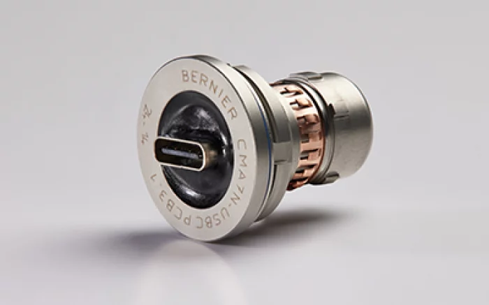
BERNIER connect S.A.S
CMA-USBC Connector
BERNIER designed the CMA-USBC line specially for equipment in harsh environments. The CMA-USBC connectors are Push-Pull military connectors that offer many possibilities of electronic integration as : USB Memory key, Authentification key, Wireless module, Crypto and Shunt module…
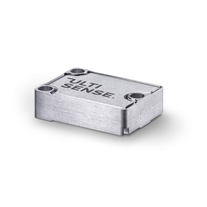
SAFRAN
ULTISENSE
Ultisense™ is Safran Vectronix’s line of high-performance OEM sensing modules, including ultra-compact Laser Rangefinders (LRF) and Digital Magnetic Compasses (DMC). Designed for seamless integration into military and civilian systems, they offer exceptional accuracy, ruggedness, and Swiss precision. LRF modules measure distances up to 30 km with ±1 m accuracy, while DMC modules provide azimuth accuracy down to 0.25°, even under extreme shock and environmental conditions.

View page in English


디렉터리 기능
전시회 도우미
In-depth Exhibitor Profiles
Each exhibitor can add as many products and services as they wish, with in-depth information and specifications. This allows buyers to find what they want easily.
Self Provisioning for Exhibitors
Each exhibitor has full control of their content - to edit their company profile, upload products and enter staff details.
방문 계획 수립
북마크 도구와 이벤트 플래너를 사용해 방문하고자 하는 기업과 관심 있는 제품을 검색하세요. 저장한 모든 항목을 조회할 수 있습니다
고급 검색
고급 검색 기능을 사용하여 상품, 인물, 기업의 위치를 빠르게 조회할 수 있습니다. 최첨단 기술을 통해 모든 참가사의 정보를 철저히 스캔하여 세밀하고 관련성 있는 정보를 제공합니다
상호작용 가능 평면도
디렉터리를 사용해 전시회를 손쉽게 둘러보세요. 방문하고자 하는 기업의 위치와, 행사장 내 식당, 화장실, 출입구를 평면도에서 찾을 수 있습니다.
플랫폼 내 메시지
플랫폼 상의 전시 참가사와 관람객에게 직접 연락하여 미팅을 신청하거나 추가 정보를 요청하세요.
최신 콘텐츠
기업, 상품, 뉴스, 이벤트
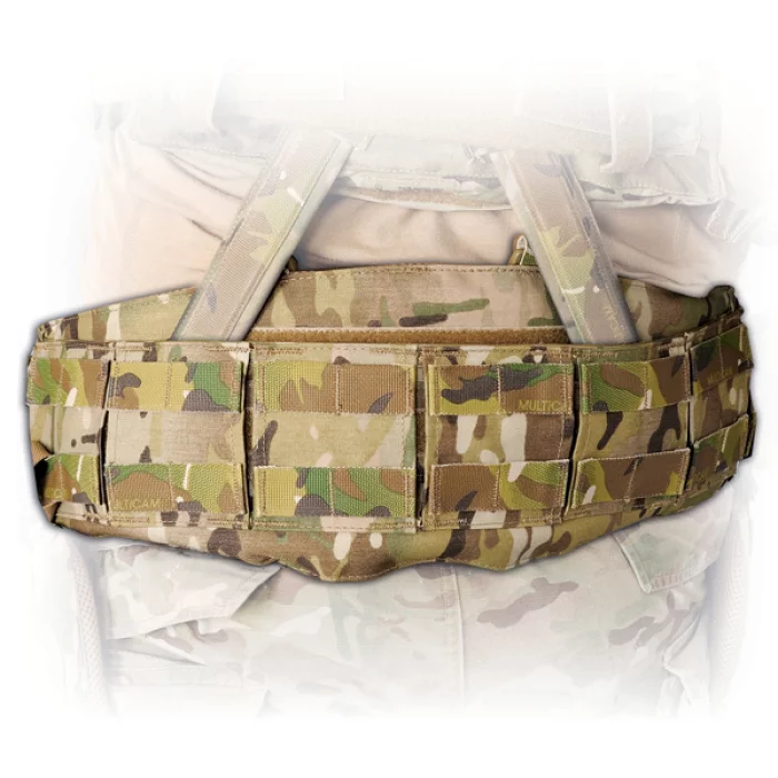
Hessed Korea
GUNFIGHTER LOAD CARRIAGE BELT - XFRAME
Dynamic Load Carriage® system
Dim. : 6.5" W
PALS webbing for MOLLE attachment
Patented Ballistic Vein®
Composition
Material : 500D Cordura® + ARAMID / PV®
Size : SMALL 26" - 30" MEDIUM 29" - 33"
LARGE 32" - 36"
XLARGE 36" - 40"
Colors:
MC (MultiCam)
BMC (Black MultiCam)
BK (Black)
RG (Ranger Green)
CYT (Coyote Brown)
_700.webp)
BELL Textron Inc.
Bell 505
The sky’s the limit with the Bell 505. A high-tech flight deck and adaptable cabin design make it an extremely cost-competitive, and capable for any challenge.
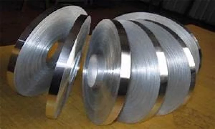
POONGSAN CORPORATION
Stainless Steel Strips & High Nickel Alloys
Poongsan Special Metals produces and supplies high-quality materials for high-tech parts based on the best metal rolling technology and new technology development achievements.
Poongsan Special Metals, which specializes in thin plate, narrow width, and hard products, is leading the technological development of the demand industry and satisfying the various conditions required for material processing such as pressing, drawing, bending, and welding to meet the needs of consumers. It greatly contributes to improving the performance of finished products.
Poongsan Special Metals produces high-precision, high-performance materials that meet customer needs through precision slitting machines, tension levelers, tension annealing furnaces, various cutting-edge facilities, and computer control systems such as AGC (Automatic Gauge Control) and AFC (Automatic Flatness Control). We are producing.
Based on advanced rolling and heat treatment know-how, Poongsan Special Metal's products have high thickness precision, low physical property dispersion, excellent flatness and mechanical properties, and are widely used in mobile, electronic and automobile parts that require spring properties and high functionality.
In particular, Poongsan Special Metals possesses its own manufacturing technology for surface treatment products and hard products, and produces and supplies products suitable for high-quality parts in the IT field such as information and communication fields, high-tech home appliances, and computers. In addition, in line with the trend of steadily increasing demand for high-performance products, we are continuously pursuing large-scale facility expansion and rationalization work to increase the added value of stainless steel products, and are actively investing in R&D projects for technology development.
Poongsan Special Metal produces thin plate narrow products with a thickness of 0.03 mm and a width of 3 mm in accordance with international standards such as KS, JIS, and AISI, and custom production is also possible according to customer requirements. In addition, Poongsan Special Metal's products have very high product reliability due to the use of carefully selected raw materials and perfect quality control up to final packaging.
Poongsan Special Metals is striving to produce and supply more economical and superior stainless steel and high-nickel products through continuous research and development and quality improvement, and is doing its best to satisfy customers through prompt and continuous customer service.
SM CNS
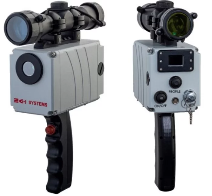
MSS
CI Systems사의 는 구성 가능한 소형 휴대용 미사일 방사 시뮬레이션 플랫폼입니다.
MSS는 항공기 이륙 라인에서 정기 검사로 또는 실험실에서 미사일 경보 시스템(MWS)의 준비 상태와 성능을 테스트할 수 있도록 합니다.
MSS는 자외선(UV) 또는 적외선(IR) 대역의 소형 방사 소스를 내장하고 있으며, 단일 또는 이중 방사 소스를 지원합니다. 이 소스는 내장된 마이크로프로세서에 의해 모드 조절되어 어떤 미사일이 방출하는 방사라도 현실적인 시뮬레이션을 제공할 수 있습니다. 사용자 친화적인 소프트웨어를 통해 어떤 테스트 프로파일도 MSS에 구성하고 업로드할 수 있습니다.
Translated with DeepL.com (free version)CI Systems’ Missile Signal Simulator (MSS) is a configurable compact, hand-held, missile radiation simulation platform.
The MSS enables the operator to test the readiness and performance of Missile Warning Systems (MWS) in the flight line as a routine test and in the laboratory.
The MSS contains a miniature radiation source in the UV or IR band, with single or dual radiation sources. They are modulated by a built-in microprocessor capable of delivering a realistic simulation of the radiation emitted by any missile. Any testing profile can be configured and uploaded onto the MSS using a user-friendly software.