한국어로 페이지 보기
Seoul ADEX 2025 Digital Directory
Plan your trip to Seoul ADEX 2025 using our state of the art Digital Directory
Register in seconds with just your email


Directory Features
To help you at the show
In-depth Exhibitor Profiles
Each exhibitor can add as many products and services as they wish, with in-depth information and specifications. This allows buyers to find what they want easily.
Self Provisioning for Exhibitors
Each exhibitor has full control of their content - to edit their company profile, upload products and enter staff details.
Plan your trip
Use the bookmarking and event planning tool to research the companies you would like to visit and the products you are interested in finding. You will be able to locate all of your saved companies on our floorplan
Advanced Search
Utilize our advanced search function to quickly locate products, people, and companies. Our state-of-the-art technology thoroughly scans all exhibitor information, delivering precise and relevant results
Interactive Floorplan
Navigate the show effortlessly with our directory. Use the floorplan to locate companies you want to visit and to find your way to onsite restaurants, toilets and site entrances and exits.
On-platform Messaging
Reach out to exhibitors and visitors directly on our platform to set up meetings, or request more information.
Some of our latest content
Companies, Products, News, Events
-jpg_700.webp)
XMW Inc.
Satcom Transmitter/Receiver(Air Series)
It is a product lineup that is proven in global markets and has world-class competitiveness.
And it is being exported to more than 20 countries around the world.
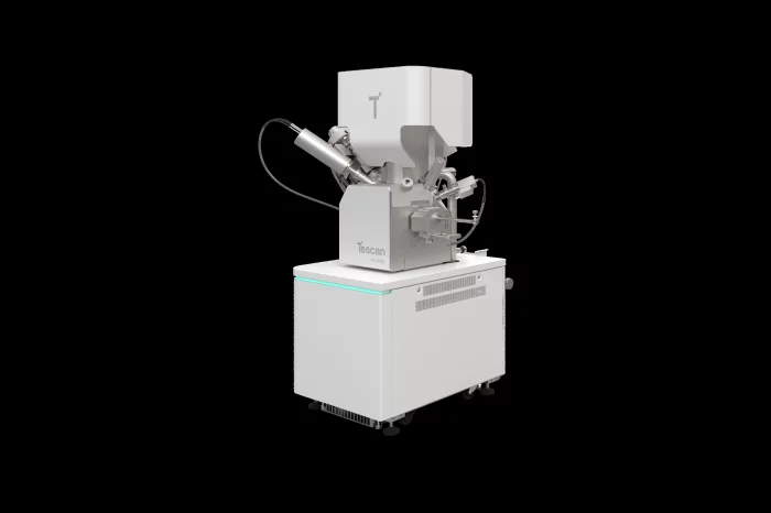
Tescan Group a.s.
TESCAN SOLARIS 2
TESCAN SOLARIS is a fully automated sample prep platform optimized for advanced devices with sub-10 nm features. It integrates the Triglav™ SEM, AutoTEM Pro™ software, and OptiLift™ nanomanipulator to enable hands-free, repeatable lamella prep in planar, inverted, or top-down geometries.
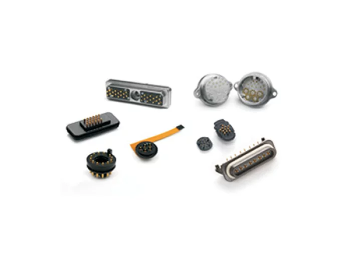
Sangdo Electronics co.,Ltd
Custom Spring Probe Connectors
Spring probes are designed to optimize performance in high reliability, multicycle applications. Smiths Interconnect’s spring probes are compliant which makes them ideal for blind mate applications as they self correct for x, y, z, rotational and angular misalignment of the target. Offered in compressed heights less than 2 mm and utilized on pitches as tight as 0.4 mm, they are well suited for high density, board-to-board, battery contact and high frequency applications. Mixed signals and functionality can be designed into a single connector.
_700.webp)
Altair
Altair Feko
- Comprehensive High-Frequency Electromagnetic Simulation
- Analysis of ships, submarines, aircraft, fighter jets, and satellites including antennas
- EMC and EMP analysis including cables
- Radome and multi-antenna interference analysis
- Wireless coverage, network planning, and spectrum management

View page in English


디렉터리 기능
전시회 도우미
In-depth Exhibitor Profiles
Each exhibitor can add as many products and services as they wish, with in-depth information and specifications. This allows buyers to find what they want easily.
Self Provisioning for Exhibitors
Each exhibitor has full control of their content - to edit their company profile, upload products and enter staff details.
방문 계획 수립
북마크 도구와 이벤트 플래너를 사용해 방문하고자 하는 기업과 관심 있는 제품을 검색하세요. 저장한 모든 항목을 조회할 수 있습니다
고급 검색
고급 검색 기능을 사용하여 상품, 인물, 기업의 위치를 빠르게 조회할 수 있습니다. 최첨단 기술을 통해 모든 참가사의 정보를 철저히 스캔하여 세밀하고 관련성 있는 정보를 제공합니다
상호작용 가능 평면도
디렉터리를 사용해 전시회를 손쉽게 둘러보세요. 방문하고자 하는 기업의 위치와, 행사장 내 식당, 화장실, 출입구를 평면도에서 찾을 수 있습니다.
플랫폼 내 메시지
플랫폼 상의 전시 참가사와 관람객에게 직접 연락하여 미팅을 신청하거나 추가 정보를 요청하세요.
최신 콘텐츠
기업, 상품, 뉴스, 이벤트
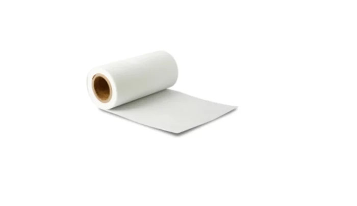
Hankuk Carbon
Glass Papers
GP division is producing Glass paper in the wet by glass fiber fabric as a main ingredient.
Glass Paper has a dimensional stability, heat resistance, chemical resistance, electrical insulation, Print Processability, heat insultion and so on. Due to its advanced quality, the Glass Paper is used by many manufacturers globally for floorings, buildings, exterior electronics.
Also, it is used for inorganic filter products, and diverse parts are under researching as its demands rise up.
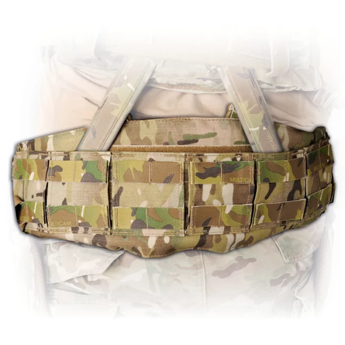
Hessed Korea
GUNFIGHTER LOAD CARRIAGE BELT - XFRAME
Dynamic Load Carriage® system
Dim. : 6.5" W
PALS webbing for MOLLE attachment
Patented Ballistic Vein®
Composition
Material : 500D Cordura® + ARAMID / PV®
Size : SMALL 26" - 30" MEDIUM 29" - 33"
LARGE 32" - 36"
XLARGE 36" - 40"
Colors:
MC (MultiCam)
BMC (Black MultiCam)
BK (Black)
RG (Ranger Green)
CYT (Coyote Brown)
EUCAST
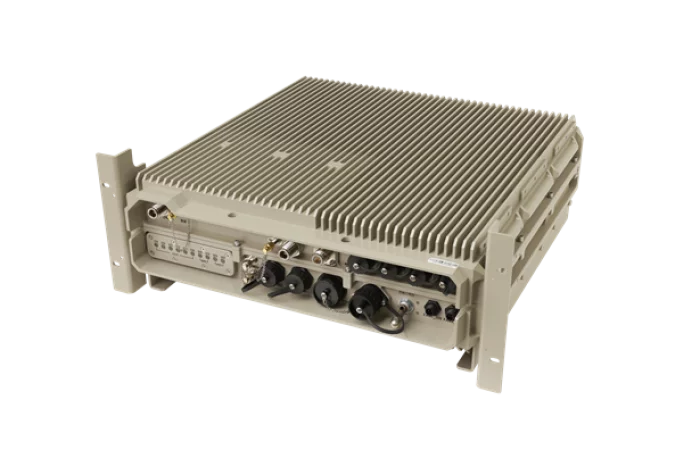
EPL4000 - Vehicle mounted 4G System (Network in a Box)
The EPL4000, like the EPL2000, is an all-in-one RU/DU/EPC/application server system that provides seamless outdoor LTE service without backhaul connection. It offers a service radius of several kilometers and is optimized for installation inside ships and vehicles.
Telcom International
RENAISSANCE
Low Insertion Loss, Good IMD Performance
RF Coaxial Switches: SPST to SP8T Switches, Transfer Switches from DC to 200 GHz
Power Dividers and Power Combiners
Wilkinson Types from 2 to 16 Ways
Frequency Range from 400 MHz to 26.5 GHz