한국어로 페이지 보기
Seoul ADEX 2025 Digital Directory
Plan your trip to Seoul ADEX 2025 using our state of the art Digital Directory
Register in seconds with just your email


Directory Features
To help you at the show
In-depth Exhibitor Profiles
Each exhibitor can add as many products and services as they wish, with in-depth information and specifications. This allows buyers to find what they want easily.
Self Provisioning for Exhibitors
Each exhibitor has full control of their content - to edit their company profile, upload products and enter staff details.
Plan your trip
Use the bookmarking and event planning tool to research the companies you would like to visit and the products you are interested in finding. You will be able to locate all of your saved companies on our floorplan
Advanced Search
Utilize our advanced search function to quickly locate products, people, and companies. Our state-of-the-art technology thoroughly scans all exhibitor information, delivering precise and relevant results
Interactive Floorplan
Navigate the show effortlessly with our directory. Use the floorplan to locate companies you want to visit and to find your way to onsite restaurants, toilets and site entrances and exits.
On-platform Messaging
Reach out to exhibitors and visitors directly on our platform to set up meetings, or request more information.
Some of our latest content
Companies, Products, News, Events
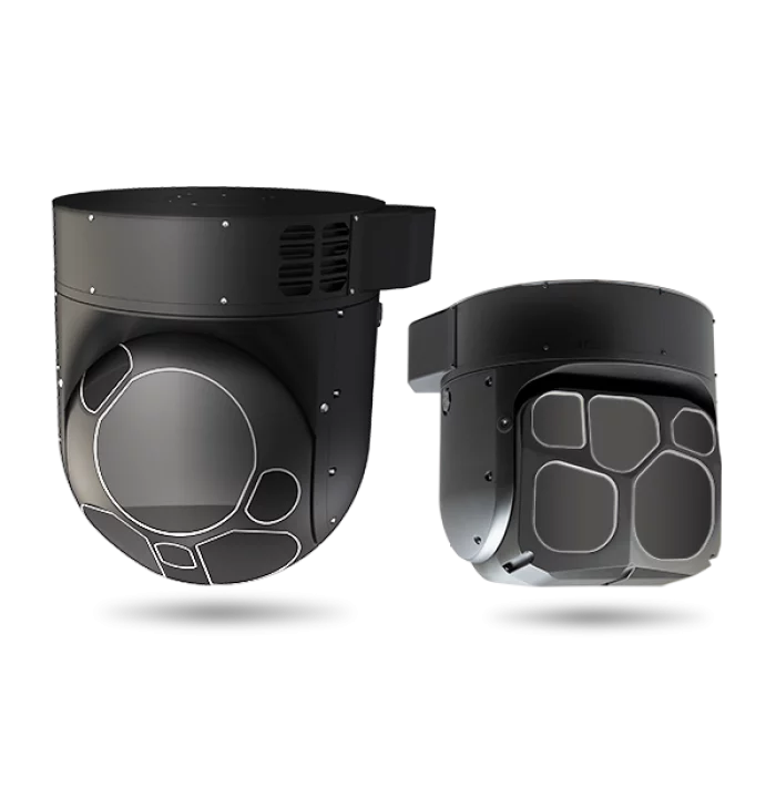
Teledyne FLIR LLC
Airborne Systems
With more than 3,000 EO/IR sensors on order or delivered, the Star SAFIRE® series provides the longest range performance in its class.
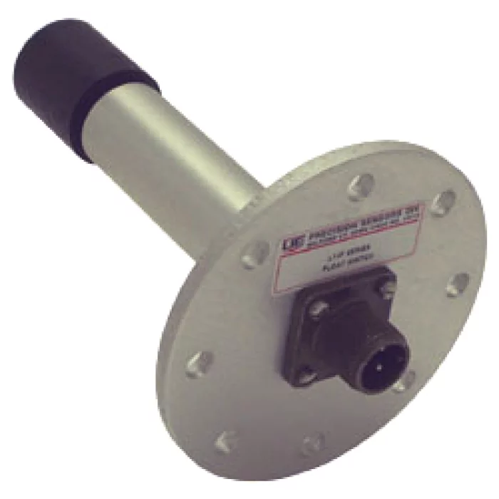
Precision Sensors
Liquid level switch
L14F type liquid level switches
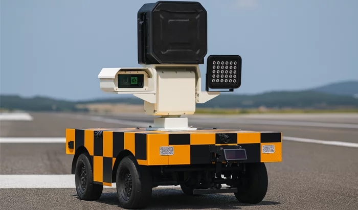
SkyAutoNet
Autonomous Bird-Repelling Robot
# Key Features
- Map Generation and No-Drive Zone Setting in Airports
> Airport map/sensor fusion-based localization function
> Function for defining main movement and standby areas
> No-drive zone setting
- Optimal Path Autonomous Driving Function
> Destination-based optimal path navigation
> Speed limit settings by path and area
> Real-time location monitoring
> Obstacle detection and immediate response
> Driving on diverse road surfaces within designated areas
- Real-Time Bird Detection and Bird Position/Direction Prediction
> Real-time bird detection
> Support for approximate bird position/direction prediction based on object detection algorithms
> Updating of approximate bird position/direction prediction based on flock detection
- Effective Bird Deterrence Reflecting Bird Characteristics
> Playback of diverse (randomized) acoustic patterns
- Real-Time Communication with Operator and Manual Control Function
> Monitoring console (PC) provides real-time bird detection status and history
> Display of approximate bird position/direction predictions on a map
> Real-time video data sharing
> Remote manual control
- Smart Charging Function
> Automatic return and charging when mission is complete or battery is low
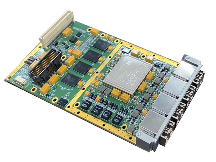
SeedCore
SCXMC-SFPDP(Serial Front Panel Data Port)
The SCXMC-SFPDP is a high-speed optical communication card that operates through the XMC interface of the SBC.
It is designed to transmit and receive large volumes of data between the SBC and other devices in real time.
Unlike Ethernet, which can be difficult to synchronize, the SCXMC-SFPDP uses optical communication with synchronization signals, enabling precise and high-speed data transfer.
It offers low response latency (<40 µs) and supports four transmit/receive channels at 3.125 Gbps per channel.
A device driver program is required for operation, and the Linux driver can be downloaded from Seedcore’s product page.
Drivers for other operating systems can be developed upon request.
This module is deployed in the L-SAM multi-function radar system to ensure reliable real-time data transmission between mission-critical subsystems.

View page in English


디렉터리 기능
전시회 도우미
In-depth Exhibitor Profiles
Each exhibitor can add as many products and services as they wish, with in-depth information and specifications. This allows buyers to find what they want easily.
Self Provisioning for Exhibitors
Each exhibitor has full control of their content - to edit their company profile, upload products and enter staff details.
방문 계획 수립
북마크 도구와 이벤트 플래너를 사용해 방문하고자 하는 기업과 관심 있는 제품을 검색하세요. 저장한 모든 항목을 조회할 수 있습니다
고급 검색
고급 검색 기능을 사용하여 상품, 인물, 기업의 위치를 빠르게 조회할 수 있습니다. 최첨단 기술을 통해 모든 참가사의 정보를 철저히 스캔하여 세밀하고 관련성 있는 정보를 제공합니다
상호작용 가능 평면도
디렉터리를 사용해 전시회를 손쉽게 둘러보세요. 방문하고자 하는 기업의 위치와, 행사장 내 식당, 화장실, 출입구를 평면도에서 찾을 수 있습니다.
플랫폼 내 메시지
플랫폼 상의 전시 참가사와 관람객에게 직접 연락하여 미팅을 신청하거나 추가 정보를 요청하세요.
최신 콘텐츠
기업, 상품, 뉴스, 이벤트
 VME3-C2 SBC_250909 (1)_700.webp)
COTS Technology
VPX3-C2 SBC
Processor
- NXP Quad Core PowerPC QorIQT2080 up to 1.8GHz
- 6 DMIPS/MHz per core (up to 43,200 DMIPS@1.8GHz)
- 128b AltiVecSIMD unit (up to 72 GFLOPs@1.8GHz)
Memory
- 4GB soldered 64-bit DDR3L SDRAM with ECC
- 256MB 16-bit NOR flash
- 64GB SATA NAND SSD
- 512KB NvRAM
Form Factor
- 3U OpenVPX
- Conduction-Cooled
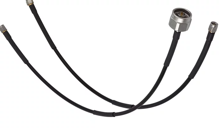
Glenair
Interconnect Cable / Conduit Assemblies
Interconnect Wire Harness and Cable Assemblies are the connectivity backbone of electronic systems. Fabricated in a factory setting, build-to-print wire harness assemblies enable the OEM manufacturer to reduce the time and expense of in situ interconnection of electronic devices used in complex air, sea, land and space applications.
funzin
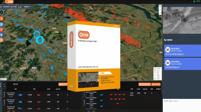
KWM : Kill Web Matching
Solution Overview
The AI-Based Command Decision Support System, "KWM," identifies battlefield targets and recommends optimal weapon system combinations. It supports end-to-end "Sensor-to-Shooter" execution for rapid, accurate, and efficient engagement and command decision-making.
Main Features
Identifies targets on the battlefield using integrated sensors and data
Recommends the most effective attack strategies for both reconnaissance and attack missions
Provides command decision support through real-time analysis and visualization
Suggests and allocates optimal target formations and strike assets
Supports on-site command and control with a user-friendly interface
Key Advantages
Enables quick, accurate, and efficient engagement of enemy targets
Automated recommendation of attack strategies and allocation of strike resources
Real-time synchronization between reconnaissance and attack kill webs
Direct connection from detection to strike (Sensor-to-Shooter capability)
Increases operational efficiency and decision-making accuracy in complex battlefield environments
Applied Cases
Successfully piloted in the Army Tiger Boost Project in 2024
Used for command decision-making and efficient allocation of attack resources in live military scenarios
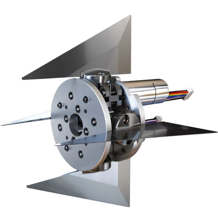
MPS bearings Co., Ltd.
Control Actuation System (CAS)
This Control Actuation System (CAS) is a guidance system for unmanned flying objects. It consists of three MPS fin actuators that each independently position an aerodynamic fin. The maximum angle of incidence is ±8°, which allows the device to carry out highly precise dynamic manoeuvres.
The miniature fin actuators that make up this Control Actuation System are manufactured by MPS Microsystems and were designed based on customer specifications. Designed to guide a very small object and disposing of an extremely limited space, these fin actuators meet strict requirements in terms of performance, weight - less than 100 g - and dimensions. To reduce the length of this actuator, MPS Microsystems used part of the screw length as the motor axis. This screw is equipped with a very compact 4-point contact bearing that simultaneously absorbs axial and radial loads. The angular play on the aileron axis is less than 0.1° rms. This actuator meets the storage and vibration requirements of military equipment.