한국어로 페이지 보기
Seoul ADEX 2025 Digital Directory
Plan your trip to Seoul ADEX 2025 using our state of the art Digital Directory
Register in seconds with just your email


Directory Features
To help you at the show
In-depth Exhibitor Profiles
Each exhibitor can add as many products and services as they wish, with in-depth information and specifications. This allows buyers to find what they want easily.
Self Provisioning for Exhibitors
Each exhibitor has full control of their content - to edit their company profile, upload products and enter staff details.
Plan your trip
Use the bookmarking and event planning tool to research the companies you would like to visit and the products you are interested in finding. You will be able to locate all of your saved companies on our floorplan
Advanced Search
Utilize our advanced search function to quickly locate products, people, and companies. Our state-of-the-art technology thoroughly scans all exhibitor information, delivering precise and relevant results
Interactive Floorplan
Navigate the show effortlessly with our directory. Use the floorplan to locate companies you want to visit and to find your way to onsite restaurants, toilets and site entrances and exits.
On-platform Messaging
Reach out to exhibitors and visitors directly on our platform to set up meetings, or request more information.
Some of our latest content
Companies, Products, News, Events

BIBUS METALS KOREA
Chemical processing
NICKEL 200 / 201
Bars-Sheets and Plates-Tubes and Pipes
MONEL® ALLOY 400
Bars-Sheets and Plates-Tubes and Pipes
MONEL® ALLOY K-500
Bars
INCONEL® Alloy 600
Bars-Sheets and Plates-Tubes and Pipes-Wire
INCONEL® Alloy 601
Bars-Sheets and Plates-Tubes and Pipes-Wire
INCONEL® Alloy 625
Bars-Sheets and Plates-Tubes and Pipes
INCONEL® Alloy 625LCF®
Sheets and Plates
INCONEL® Alloy 693
Sheets and Plates-Tubes and Pipes
INCONEL® Alloy C-276
Bars-Sheets and Plates-Tubes and Pipes
INCONEL® Alloy 22
Bars-Sheets and Plates-Tubes and Pipes
INCOLOY® Alloy 800 H / HT
Bars-Sheets and Plates-Tubes and Pipes
INCOLOY® Alloy 825
Bars-Sheets and Plates-Tubes and Pipes
Titanium Grade 1
Strip
Titanium Grade 2
Bars-Sheets and Plates-Tubes and Pipes
Titanium Grade 7
Bars-Sheets and Plates-Tubes and Pipes
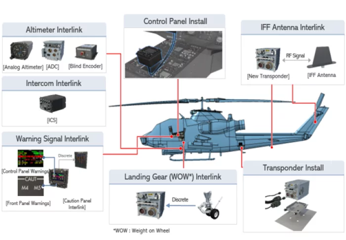
Kencoa Aerospace
MRO
1. Maintenance
• Depot Maintenance
• Structure & Avionics Replacement, Repair, Wire Harness, Test and Inspection
2. Upgrade & Modification
• Structure Upgrade and Modification
• Avionics Upgrade, System Integration, Test and Inspection
Highlights
√ Final Assembly incl. Engine Installation
√ System Integration, Test & Inspection
Project Highlight :
KT-100 & Light Sport Aircraft (Final Assembly), HH-60, CH-53, CH-47, F-16, P3-c, C-130H, AS-1S, MD500, NG RQ-4B ( Logistic & Ground Support)
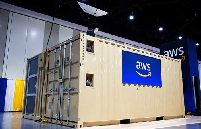
Amazon Web Services
AWS Modular Data Center
Instead of relying on limited data center infrastructure or building from the ground up, AWS Modular Data Center delivers a cost-effective, self-contained modular data center solution that supports customers’ data center scale workloads. With this offering, defense customers can securely store, analyze, and interpret petabytes worth of data in real-time to gain military advantage in the most isolated environments.
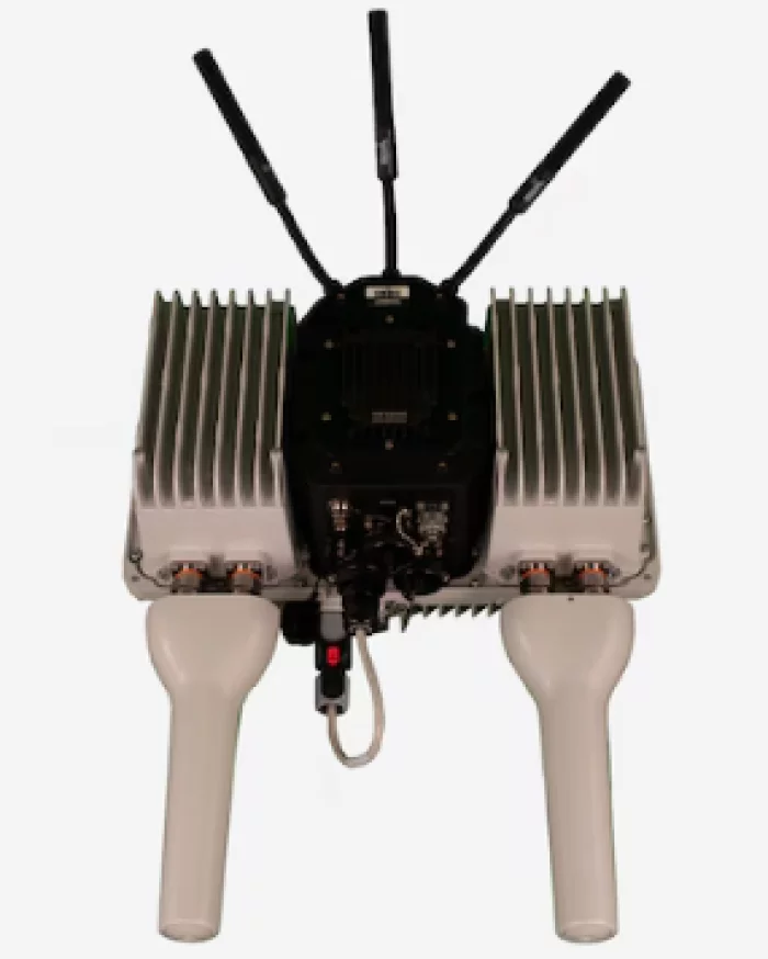
Nokia
Banshee 4G Mobile Radio
The Nokia Banshee 4G Mobile Radio is purpose-built to keep warfighters and their devices connected in contested environments. Built for mobility, the Banshee 4G Mobile Radio delivers a secure network with extended range no matter how remote the mission.
Designed to operate on the move or at the quick halt, the Banshee 4G Mobile Radio brings unprecedented throughput and interoperability for real-time shared Situational Awareness and greater standoff for Command and Control.

View page in English


디렉터리 기능
전시회 도우미
In-depth Exhibitor Profiles
Each exhibitor can add as many products and services as they wish, with in-depth information and specifications. This allows buyers to find what they want easily.
Self Provisioning for Exhibitors
Each exhibitor has full control of their content - to edit their company profile, upload products and enter staff details.
방문 계획 수립
북마크 도구와 이벤트 플래너를 사용해 방문하고자 하는 기업과 관심 있는 제품을 검색하세요. 저장한 모든 항목을 조회할 수 있습니다
고급 검색
고급 검색 기능을 사용하여 상품, 인물, 기업의 위치를 빠르게 조회할 수 있습니다. 최첨단 기술을 통해 모든 참가사의 정보를 철저히 스캔하여 세밀하고 관련성 있는 정보를 제공합니다
상호작용 가능 평면도
디렉터리를 사용해 전시회를 손쉽게 둘러보세요. 방문하고자 하는 기업의 위치와, 행사장 내 식당, 화장실, 출입구를 평면도에서 찾을 수 있습니다.
플랫폼 내 메시지
플랫폼 상의 전시 참가사와 관람객에게 직접 연락하여 미팅을 신청하거나 추가 정보를 요청하세요.
최신 콘텐츠
기업, 상품, 뉴스, 이벤트
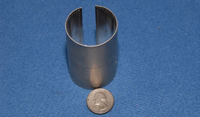
Haigh-Farr, Inc.
Conformal Antennas
The Haigh-Farr Wraparound™is a self-contained, omnidirectional antenna for cylindrical or conical shaped vehicles. A single point feed is used and no external splitters, combiners or cable harnesses are required for installation. The antenna may be mounted flush, or on the exterior of the vehicle.
_700.webp)
Syscom Korea Co., Ltd.
Camera link Fiber Optic Extender FOR-30T/R , Base/Medium/Full configuration
*Perfect automatic camera matching for all types of vision cameras.
*Fully supports the Camera Link interface (Area/Line Scan).
*User-friendly,No need to modify firmware for frequency compatibility.
*Compatible with "10 TAPS@85MHz" internal/external RS232C,
all baud retes(20MHz~85MHz),and digital user IO.
*Compatible with Base/medium/Full configurations.
*Provides camera power from the Tx box.
*SFP type module
*Works with moving and non-moving fiber cables.
Finished Solution
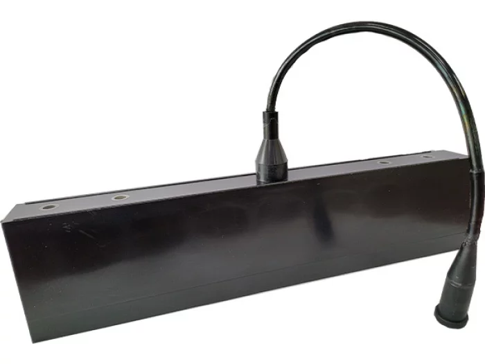
SONAR SENSOR
Iniaturization model for UAVs
Minimized Vibration & Noise by our technique
Provide an electronic board
Customized item for Military's needs

i3system, inc.
X ray Panoramic
i3system’s line scanning X-ray detector platform, XID-C15DP/XID-C24DC, is a high performance and cost effective solution for dental panoramic, cephalometric applications. i3system’s direct type sensor ensures the most sharp images among the current products in the market. XID series is designed for compact size and easy installation. High DQE(Direct Quant㎛ Efficiency) enables high performance at lower dose of X-ray.
Introduction
Indirect type X-ray detector uses the scintillator and the photo-diode(CCD or CMOS sensor) for conversion of the X-ray into the light and for taking images espectively. But the light scatters and goes extinct during it passes through the scintillator and reaches to the CCD or CMOS sensor. As a result, it is inevitable to get blurred image.
In the mean time, XID C15DP, direct type detector, converts X-rays into electronic signals directly without conversion process of light. Because X-ray is not converted into light, it provides much sharper images than indirect type detector.
XID C15DP is designed to compact for easy installation. It provides Gigabit Ethernet port on the detector for easy configuration. Instead of Gigabit Ethernet, camera link or optical interface can be provided according to requirements of users.