한국어로 페이지 보기
Seoul ADEX 2025 Digital Directory
Plan your trip to Seoul ADEX 2025 using our state of the art Digital Directory
Register in seconds with just your email


Directory Features
To help you at the show
In-depth Exhibitor Profiles
Each exhibitor can add as many products and services as they wish, with in-depth information and specifications. This allows buyers to find what they want easily.
Self Provisioning for Exhibitors
Each exhibitor has full control of their content - to edit their company profile, upload products and enter staff details.
Plan your trip
Use the bookmarking and event planning tool to research the companies you would like to visit and the products you are interested in finding. You will be able to locate all of your saved companies on our floorplan
Advanced Search
Utilize our advanced search function to quickly locate products, people, and companies. Our state-of-the-art technology thoroughly scans all exhibitor information, delivering precise and relevant results
Interactive Floorplan
Navigate the show effortlessly with our directory. Use the floorplan to locate companies you want to visit and to find your way to onsite restaurants, toilets and site entrances and exits.
On-platform Messaging
Reach out to exhibitors and visitors directly on our platform to set up meetings, or request more information.
Some of our latest content
Companies, Products, News, Events

STX Engine
Military Diesel Engine
We, STX Engine, started with our business to be designated as a defense company in 1977 and established a factory for defense purposes in 1988. Moreover, we have grown into a largest defense diesel engine manufacturer by licensing with MTU. Based on the aforementioned fact, we manufacture and provide diesel engines for main battle tank, self-propelled artillery and armored vehicle to ROK Army, for destroyer, frigate, patrol vessel and support vessel to ROK Navy, for patrol vessel to Korea Coast Guard as well.
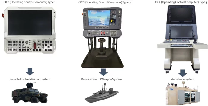
SungJin Techwin Co.,Ltd.
Operating Control computer
Sungjin Techwin develops operating control computers designed for ground and naval defense applications. Engineered for harsh environments, these ruggedized systems provide secure and real-time processing to support RCWS operations, anti-drone defense, and unmanned surface vehicle control. Built to military standards, they offer high reliability under shock, vibration, and temperature extremes while enabling seamless integration with sensors, weapons, and communication networks. By combining durability with scalable architecture, Sungjin’s operating control computers ensure mission effectiveness across diverse modern battlefield domains.

Arizona Commerce Authority
Start Up
The SBIR Training Program prepares business owners to write compelling SBIR/STTR grant applications with state-of-the-art proposal development workshops, structured mentoring, and follow-up guidance from proven business experts. SBIR (Small Business Innovation Research) and STTR (Small Business Technology Transfer) are highly competitive awards-based programs that finance small businesses hoping to commercialize their technology innovations.
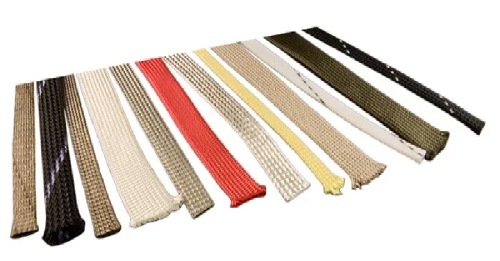
Glenair
EMI / RFI Braided Cable Shielding / Tubular Expandable Braided Cable Sleeving / Ground Straps
Metal braided sleeving and tubular expandable braided cable shielding is used primarily in the electrical wire interconnect industry to protect cables from electrostatic and electromagnetic interference. The interwoven conductive wire acts as a ground-path barrier that attenuates cable electrical field interference. In addition, both metallic and non-metallic braided shielding provides abrasion and cut protection for critical wiring, a particular concern in environments, such as aircraft, where vibration or other forms of rough handling may result in damage to individual wire conductors and cable bundles.
Glenair manufactures the world's most innovative line of metal, monofilament non-metallic, and microfilament composite and stainless steel braiding solutions for environmental, mechanical, and EMC shielding in interconnect cable assemblies. Our industry-leading ArmorLite braided shielding is manufactured from ultra-lightweight stainless steel microfilaments, metal-clad for optimal conductivity and EMI/RFI shielding. Our AmberStrand tubular braided shielding is built from a lightweight composite thermoplastic microfilament, with or without additional metal filaments and plated for outstanding grounding and shielding protection.
From high-temperature fiberglass tubular shielding for engine applications to ultra-lightweight EMI/RFI braided shielding for electrical wire interconnect grounding applications, Glenair offers the industry's most innovative range of solutions.

View page in English


디렉터리 기능
전시회 도우미
In-depth Exhibitor Profiles
Each exhibitor can add as many products and services as they wish, with in-depth information and specifications. This allows buyers to find what they want easily.
Self Provisioning for Exhibitors
Each exhibitor has full control of their content - to edit their company profile, upload products and enter staff details.
방문 계획 수립
북마크 도구와 이벤트 플래너를 사용해 방문하고자 하는 기업과 관심 있는 제품을 검색하세요. 저장한 모든 항목을 조회할 수 있습니다
고급 검색
고급 검색 기능을 사용하여 상품, 인물, 기업의 위치를 빠르게 조회할 수 있습니다. 최첨단 기술을 통해 모든 참가사의 정보를 철저히 스캔하여 세밀하고 관련성 있는 정보를 제공합니다
상호작용 가능 평면도
디렉터리를 사용해 전시회를 손쉽게 둘러보세요. 방문하고자 하는 기업의 위치와, 행사장 내 식당, 화장실, 출입구를 평면도에서 찾을 수 있습니다.
플랫폼 내 메시지
플랫폼 상의 전시 참가사와 관람객에게 직접 연락하여 미팅을 신청하거나 추가 정보를 요청하세요.
최신 콘텐츠
기업, 상품, 뉴스, 이벤트
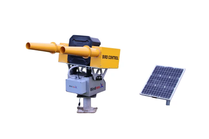
Parkor Korea Indus
Bird Control Equipment
Effective bird control is prominent for mitigating potential Bird Strike risks at civil airports, airbases and wind farms. Our field proven bird control equipments developed through years of research contribute to safety and protection of valuable assets.
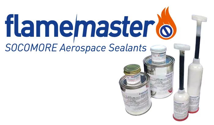
CBOL Corporation
Flamemaster (Socomore Aerospace Sealants)
FLAMEMASTER has formulating and compounding capabilities for sealants, adhesives, and coatings made from polysulfides, epoxies, silicones, and rubbers, among others.
The product line includes corrosion-resistant materials, mid- and lightweight sealants, electrical potting compounds, and thermal barriers.

RF Systems
Long Range RADAR (LRR)
24-7 non-stop operating RADAR for ceaseless aerial surveillance and early trajectory detection.
Design and Manufacture
- Antenna Housing
- Driving Unit
ViscoTec Pumpen- u. Dosiertechnik GmbH
Mobile Mix-on-Demand System
The semi-automatic ViscoTec mix-on-demand station is already in successful use as a mobile system. For reliable mixing and dosing of two-component materials, in situ.
Two-component materials are commonly processed using premix cartridges, hardener rod cartridges or by mixing two components by hand. The disadvantages are obvious: The risk of human error, enormous material waste and high production costs offer every reason for taking the automated route.
With ViscoTec filling stations, epoxy resins, polysulfides and polyurethanes can be removed from larger containers and filled on-demand with the exact quantity required. The dosing is volumetric on a component or a filling container. A typical application is dosing in so-called inserts (thread inserts). The compact arrangement of the components on a mobile frame guarantees the operator maximum flexibility. The design as a stationary system has already been implemented several times.