한국어로 페이지 보기
Seoul ADEX 2025 Digital Directory
Plan your trip to Seoul ADEX 2025 using our state of the art Digital Directory
Register in seconds with just your email


Directory Features
To help you at the show
In-depth Exhibitor Profiles
Each exhibitor can add as many products and services as they wish, with in-depth information and specifications. This allows buyers to find what they want easily.
Self Provisioning for Exhibitors
Each exhibitor has full control of their content - to edit their company profile, upload products and enter staff details.
Plan your trip
Use the bookmarking and event planning tool to research the companies you would like to visit and the products you are interested in finding. You will be able to locate all of your saved companies on our floorplan
Advanced Search
Utilize our advanced search function to quickly locate products, people, and companies. Our state-of-the-art technology thoroughly scans all exhibitor information, delivering precise and relevant results
Interactive Floorplan
Navigate the show effortlessly with our directory. Use the floorplan to locate companies you want to visit and to find your way to onsite restaurants, toilets and site entrances and exits.
On-platform Messaging
Reach out to exhibitors and visitors directly on our platform to set up meetings, or request more information.
Some of our latest content
Companies, Products, News, Events
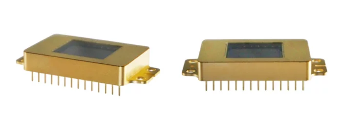
i3system, inc.
InGaAs(SWIR)
Specification
Array Format : 1280 × 1024
Pixel pitch : 10㎛
Spectral range : 0.9㎛ ~ 1.7㎛ (SWIR)
Operability : ≥ 99.5%
Quantum Efficiency : 70% @ 1550nm
Application
Near-infrared Imaging
Imaging Spectroscopy
Surveillance
Medical Science and Biology
Astronomy and Scientific
Material inspection
Food inspection
Forgery detection
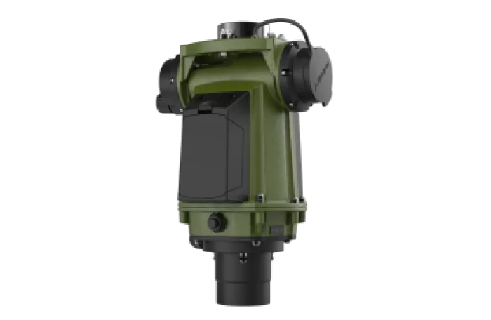
SAFRAN
STERNA
STERNA System accurately finds True North in virtually all terrains and regardless of the weather conditions. The performance of STERNA System is not disturbed by gear carried by its operator or if used next to heavy armored vehicles. It remains highly accurate even when deployed on reinforced concrete floors or in dense urban settings. STERNA System operates reliably even in GPS denied environments and does not require the operator to carry any support resources to determine True North. If your mission success depends on the highest level of accuracy and precision, there is no substitute for STERNA System.
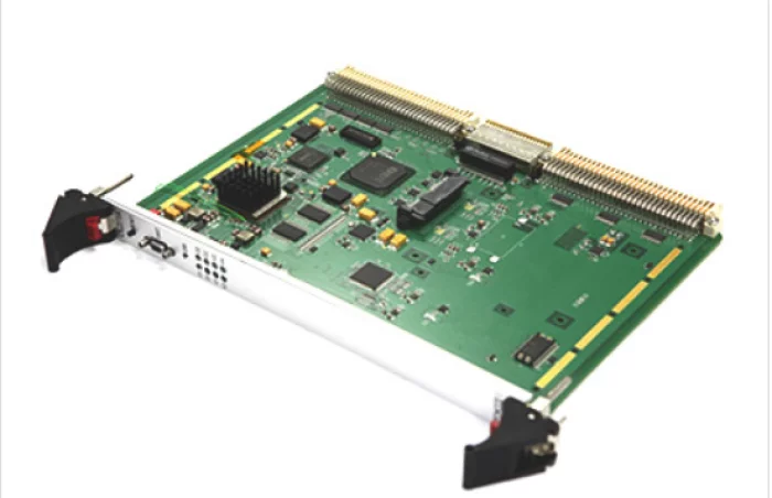
OLZETEK Inc.
Image processing SBC Single Board Computer for Image Processing
SBC (single board computer) for VMEbus based on TI DaVinci CPU, ARM Cortex-A8 1.2GHz, C674x 1GHz DSP, SGX530 3D Graphics Engine, DDR3 memory, Giga Ethernet 2 port, video input/output 5 port, SATA-2 2.5" SDD This is a built-in SBC board for video processing.
Application field:
image processing system
Shipboard EO video system
Video encoder/decoder system
Multi-channel video storage/distribution system
Characteristic:
VME type multi-channel video recorder
Supports 4-channel NTSC/PAL video compression (H.264)
Supports 4-channel audio recording
Supports local video and audio playback
Supports network RTSP function
Supports Ethernet-based GUI control
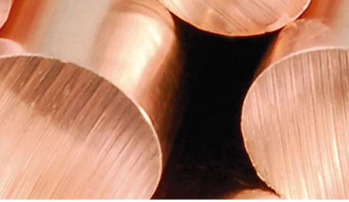
POONGSAN CORPORATION
Copper and copper alloy plates/plates
Poongsan has been producing a variety of copper and copper alloy plates, ranging from copper products for everyday life to high-tech industrial materials.
These copper and copper alloy plates, which are recognized as high-quality materials at home and abroad, are representative industrial basic materials that are widely used in all industrial fields, including automobiles, electrical and electronics, semiconductors, communications, construction, and machinery.
Poongsan has various casting facilities, including the world's largest shaft furnace, a hot mill capable of continuously rolling 6-ton slabs, a tandem mill, and a 20-stage cold rolling mill, as well as various hot and cold rolling facilities and heat treatment furnaces. We are building a large-scale integrated production system from the casting process to finishing processes such as cutting and packaging.
Poongsan's rolled products are produced in various sizes depending on the type, ranging from 630mm in width, 0.03mm in thickness, and thickness tolerance to 2/1000mm. These products have accurate specifications and physical properties and a smooth surface thanks to the establishment of a thorough quality control system using cutting-edge inspection equipment. Excellent.
Poongsan's copper and copper alloy rolled products are produced in a variety of ways, including pure copper, brass, phosphor bronze, nickel silver, cupronickel, and special alloy (PMC26 and other) depending on the alloy composition and casting method. In particular, in response to market demands for new high-strength copper alloys due to technological advancements such as the Internet of Things and electric vehicles, we have developed new alloys (P1000HS and others) and are applying them to high-tech products requested by customers.

View page in English


디렉터리 기능
전시회 도우미
In-depth Exhibitor Profiles
Each exhibitor can add as many products and services as they wish, with in-depth information and specifications. This allows buyers to find what they want easily.
Self Provisioning for Exhibitors
Each exhibitor has full control of their content - to edit their company profile, upload products and enter staff details.
방문 계획 수립
북마크 도구와 이벤트 플래너를 사용해 방문하고자 하는 기업과 관심 있는 제품을 검색하세요. 저장한 모든 항목을 조회할 수 있습니다
고급 검색
고급 검색 기능을 사용하여 상품, 인물, 기업의 위치를 빠르게 조회할 수 있습니다. 최첨단 기술을 통해 모든 참가사의 정보를 철저히 스캔하여 세밀하고 관련성 있는 정보를 제공합니다
상호작용 가능 평면도
디렉터리를 사용해 전시회를 손쉽게 둘러보세요. 방문하고자 하는 기업의 위치와, 행사장 내 식당, 화장실, 출입구를 평면도에서 찾을 수 있습니다.
플랫폼 내 메시지
플랫폼 상의 전시 참가사와 관람객에게 직접 연락하여 미팅을 신청하거나 추가 정보를 요청하세요.
최신 콘텐츠
기업, 상품, 뉴스, 이벤트
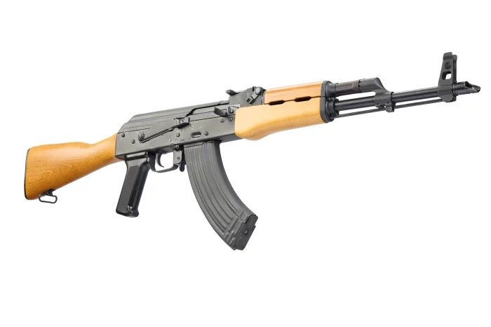
NOVA MODUL SRL
RAK1 M Rifle
A reliable, quality full or semi-auto version of the rifle that has written entire volumes in history.
A basic, non-nonsense version that stays true to the original.
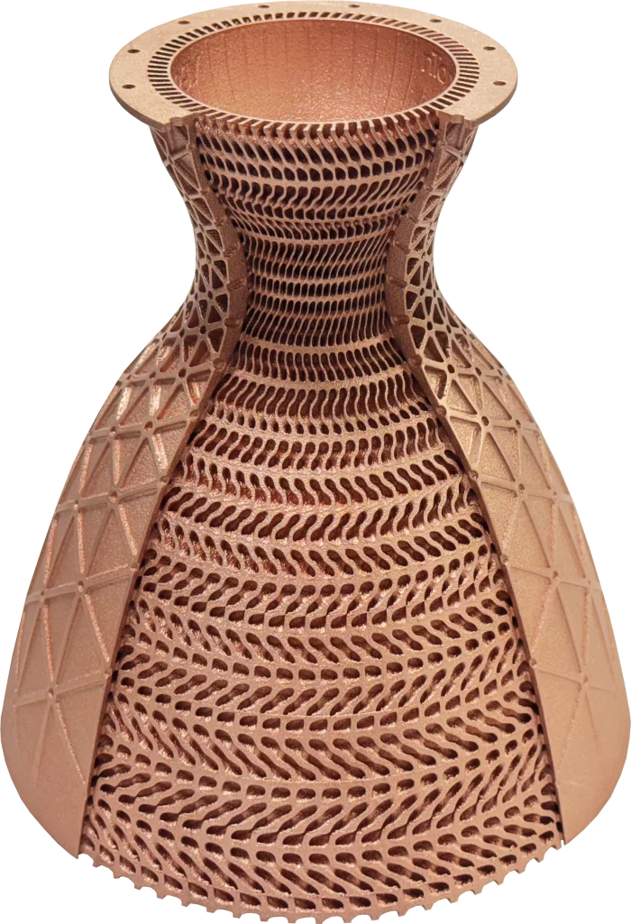
PARTNERS LAB Co., LTD.
Rocket nozzle with conformal cooling channels and isogrid ribbing
This rocket nozzle featuring conformal cooling channels and isogrid ribbing was manufactured using EOS Copper CuCP, a pure copper material optimized for additive manufacturing. The production required approximately 72 hours, taking advantage of the exceptional thermal and electrical conductivity of pure copper to meet demanding aerospace performance requirements.
As one of the few companies in Korea capable of performing metal additive manufacturing with pure copper, we provide advanced technical expertise and support OEM production as well as collaborative technology development projects with various industrial partners.
The showcased component was designed by nTopology and demonstrates the synergy of advanced design optimization with state-of-the-art copper additive manufacturing.
_700.webp)
W. L. Gore & Associates
GORE® Spaceflight Microwave/RF Assemblies
Spacecraft are exposed to extreme conditions that can jeopardize signal transmission capabilities, making it impossible for repairs in space. Whether traveling millions of miles for exploration or enabling global connectivity, space programs need durable solutions with reduced size and weight they can trust to perform without failure. W. L. Gore & Associates answers the call with small, low-mass GORE® Spaceflight Microwave/RF Assemblies proven to maintain electrical and mechanical performance in the harshest environments, ensuring mission readiness and success.
Integrated Procurement Technologies
Anti-Submarine Warfare (ASW)